azure
Final Approach
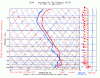
I'm looking at the weather closely today. Both the FA and the TAFs indicate a good chance of IFR conditions, and best of all, lowest freezing level is about 10,000 feet. The only fly in the ointment is the possibility of convective weather -- I'll have to watch convective outlooks and radar very closely. Well, actually two flies: the column doesn't look very saturated later in the afternoon except up around MBS, which is the earliest I'll be able to get to the airport.
LM LWR MI LH
N HLF..OVC015 TOP 080. TIL 12Z OCNL VIS 3SM BR. BECMG 1820 OVC015
TOP FL240. VIS 5SM -RA BR. OTLK..IFR CIG.
S HLF..OVC015 TOP 080. VIS 3SM BR. BECMG 1416 OVC015 TOP FL240.
VIS 3SM -RA BR. OTLK..IFR CIG.
.
KPTK 091539Z 0916/1012 14008KT P6SM -SHRA SCT007 BKN035
FM091800 14008KT 5SM -RA BKN025 OVC040
FM092300 07004KT 4SM BR OVC007
FM100600 04003KT 2SM -RA BR OVC005
Other than the two products I mentioned above, what forecasting tools do people here use to assess chances of convection? This will be my first thunderstorm season since getting my rating, so I don't have a lot of (actually, any) experience with convective weather.