Go-NoGo weather

skidoo

Line Up and Wait
Joined
Nov 13, 2009
Messages
987
Location
Montana
Display Name

Display name:
skidoo
I've been this route once in clear weather, but may travel this route often. I was out in the local area and noticed these low clouds along this cross country route. So, I was thinking what if this was there on a day I would travel. For VFR only, would you go across these (on top)? Destination is about 280NM beyond towards the center of the picture.
 

Attachments

  • HT0_7063-1 (Small).jpg
    HT0_7063-1 (Small).jpg
    67.2 KB · Views: 75
I've been this route once in clear weather, but may travel this route often. I was out in the local area and noticed these low clouds along this cross country route. So, I was thinking what if this was there on a day I would travel. For VFR only, would you go across these (on top)? Destination is about 280NM beyond towards the center of the picture.

NFW.

If you have the skills to go down through on the other side when you find that the forcast is wrong (what's the chance of that?) fine. But I don't.
 
Only on an IFR flight plan with an approach book handy and me current in a capable aircraft to fly an approach to minimums and try it twice, with enough fuel to get to a better weather airport.

Otherwise, no.
 
All a matter of planning and knowing your area weather.

I'm not sure where you are, but I'm guessing somewhere out west with real mountains. So, I would talk to locals who know the weather out there. I know when I've flown out there the weather has a good sum of differences than the east.

On the surface, though, that looks like patchy clouds and the layer is below you but above the ground, and easy to descend around. I'd likely go (have to do a lot more looking at the weather first), but make sure I had enough fuel for options.
 
What time of the day was that taken? Early in the morning? What was the forecast? What is is like at the destination? Many times mountain valleys have low clouds early in the morning which dissipate fairly quickly.
 
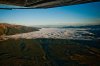
Well, that was taken about 45 minutes before sunset. But, I would not be going that late. It would be morning or early afternoon only. The forecast was for mostly sunny most of the route. When I took the photo, it appeared to me that the low clouds ended probably no more than 50 miles out. The route takes me mostly along valley routes with just a couple short ridge crossings. The highest peaks are in my local area and no more than about 10K. I would tend to cruise at 10500, 11500, or 12500.

So, suppose this is what you saw about 30 miles from departure in the morning with mostly sunny skies forecast and it appeared the low clouds may end 50 miles out. Does this change your outlook? Would you continue and see, or would you turn around now?

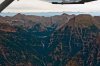
By the way, this is just to the left of the first picture. Normally, I climb along this range for the first 30 miles, and then turn towards that valley. This is about the highest peak near 10K.
 

Attachments

  • HLR_1477-7 (Medium).jpg
    HLR_1477-7 (Medium).jpg
    164.8 KB · Views: 35
So, suppose this is what you saw about 30 miles from departure in the morning with mostly sunny skies forecast and it appeared the low clouds may end 50 miles out. Does this change your outlook? Would you continue and see, or would you turn around now?
I must be blind because I don't see any low clouds in that picture or do you mean the overcast? It's really hard to judge how low that is from a photograph. I guess what I'm trying to say is that I wouldn't automatically discount flying over some low clouds, it depends on many factors especially the conditions you expect at your destination. The most important thing is to leave yourself an out if things go downhill.
 
I must be blind because I don't see any low clouds in that picture or do you mean the overcast? It's really hard to judge how low that is from a photograph. I guess what I'm trying to say is that I wouldn't automatically discount flying over some low clouds, it depends on many factors especially the conditions you expect at your destination. The most important thing is to leave yourself an out if things go downhill.


Valley floor is about 3000-3500 ft. Top of clouds are about 5500 ft. Photo taken about 7500 ft. I estimate the cloud layer to be no more than about 500 ft thick. So, I believe the bottom of the clouds at least 2000 ft AGL from the valley bottoms. But, obviously, there are points at 0 AGL.
 
I would call Flight Watch if possible in the mountains, and get the weather at points on down the line. If it's just a band of clouds 50 miles wide, why not?
 
I don't have any mountain flying experience, but I'll pretend this is in an area that I'm familiar with and only consider the cloud layer. For me it would depend on how well the "mostly sunny" forecast was playing out otherwise, and whether there was any trend for those clouds to dissipate near my destination, looking over the last few hours. Flying VFR-only around the Great Lakes, I'm always very skeptical of "that'll burn off in a couple hours" forecasts and need to see some sign that an optimistic forecast is coming true before I'll believe it. Even then, as others have said, before I would launch I would need to have a sure out (preferably more than one) in case the weather turns around and goes downhill. In practice, the only time I've gone on top over an expansive overcast, I've known for 100% sure that it was clear at my destination and would stay that way, with a clearing trend under way en route.
 
So, suppose this is what you saw about 30 miles from departure in the morning with mostly sunny skies forecast and it appeared the low clouds may end 50 miles out. Does this change your outlook? Would you continue and see, or would you turn around now?

How much fuel do I have?

If I'm in the trusty 182, sure I'd go. 6 hours of fuel gives you a LOT of options. So I guess my real answer to this question is, *IF* I like what I see in terms of other conditions along the route, forecasts, etc. and I have enough fuel to go to where the weather's good, sure.
 
As a VFR pilot, you have to think carefully about the conditions at your destination. They have to be clear, not forecast clear. I'd go over a layer like that without thinking twice about it, I do similar things to get over mountains all the time. But I check conditions at my destination very frequently, and make certain I have gas to get back to my starting point until I'm well past the undercast.

I figure if I have an engine failure on top of an overcast, I go through. Its an emergency, so I can do what I need. I'd like to think I can hold the shiny side up for the minute or two it takes me to transit the clouds. Below them I have however much time to find somewhere to land, but it would be no different if I were flying under the clouds VFR.
 
Back
Top