Go-NoGo Fog

Would you

  • Depart IFR

    Votes: 30 54.5%
  • Depart VFR

    Votes: 3 5.5%
  • No-Go

    Votes: 22 40.0%

  • Total voters
    55

skidoo

Line Up and Wait
Joined
Nov 13, 2009
Messages
987
Location
Montana
Display Name

Display name:
skidoo
So, I am sitting at home looking at the fog out the window and wondering if I had my IR and I had to go somewhere, would I go. The conditions are as follows:

Weather depiction chart - Clear everywhere for hundreds of miles except here.
Temp - 35F
Ground fog - visibility 1/4 mile
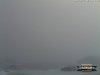
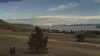
viewing nearby web cams, fog thickness is about 800 ft, clear on top - see photo - Airport is under that fog layer.
Destination and everywhere nearby is clear.
Approach procedures at the departure airport has 1600 ft AGL MDA and 1/1/4 vis for a GPS instrument approach. So, there is not returning after take off. There would also be no one coming in.

For you IFR pilots - Would you depart in these conditions?

For the VFR pilots who think they can handle IMC and don't care much for regs, would you depart VFR and punch through without talking to anyone?

Edit: you can take off over water, so you know there are no obstacles.
Say you are flying a single 4 place with under 260 HP.
 

Attachments

  • fog.jpg
    fog.jpg
    63.6 KB · Views: 55
Last edited:
Nope. Relatively low risk, but very high consequence.
 
What are we flying? What % of rwy available is required for takeoff?
 
IFR, I'd depart in a heartbeat -- plenty of options and enough vis to stop if I see something ahead on the runway during takeoff.

VFR, not a chance in the world. And don't bet your life that there's nobody having a look-see IFR despite the low reported vis.
 
IFR, I'd depart in a heartbeat -- plenty of options and enough vis to stop if I see something ahead on the runway during takeoff.

VFR, not a chance in the world. And don't bet your life that there's nobody having a look-see IFR despite the low reported vis.

I personally would not consider the VFR option. But, since the MDA is 800 ft above where the top of the fog is, would an IFR pilot be looking that far below the MDA?
 
I personally would not consider the VFR option. But, since the MDA is 800 ft above where the top of the fog is, would an IFR pilot be looking that far below the MDA?
In theory? No. But until you're up there looking down, you don't know what you can see from MDA, so you can't be sure nobody will be trying it. It's not been often, but there have been times when I've seen the runway just fine from DH/MDA, and then dropped into the ground fog.:yikes:
 
In theory? No. But until you're up there looking down, you don't know what you can see from MDA, so you can't be sure nobody will be trying it. It's not been often, but there have been times when I've seen the runway just fine from DH/MDA, and then dropped into the ground fog.:yikes:

That is interesting. I'm glad I asked.
 
How widespread is the fog, and where is the nearest airport with suitable VFR weather? I'm not a big fan of departing IFR in a single without having an airport somewhat nearby that I know I can get back into -- preferably with VMC. As far as departing VFR goes, not only would that be irresponsible, it'd also be illegal.
 
All I know is i think I want to move to Montana now.
 
Really depends. In a single, I typically only like to launch when the weather is atleast at non-precision appoach minimums or the published takeoff mins (remember, just because we don't have to use them under part 91 doesn't mean they don't have a purpose). If you're going to launch in real low weather, it's typically a good idea to have some kind of takeoff alternate set up just in case something happens (ex. a nearby field that is reporting at or above mins etc).
 
How widespread is the fog, and where is the nearest airport with suitable VFR weather? I'm not a big fan of departing IFR in a single without having an airport somewhat nearby that I know I can get back into -- preferably with VMC.

Looks like about 50 miles to any airport with no fog. Here is a web cam of a near airport.

As far as departing VFR goes, not only would that be irresponsible, it'd also be illegal.

Sure, we all know that. But, we also know that a small percentage of us take excessive risks, and some of them end up on the NTSB list. Just wondering if the poll percentage would have any correlation to the NTSB statistics.
 

Attachments

  • now.jpg
    now.jpg
    13.6 KB · Views: 37
Last edited:
Nearest airport in VMC is about 21 miles. But, it is across some mountains (the ones holding the fog in). It is in this valley, but is a turf field and likely not plowed. There is another one about 18 miles with paved, over some smaller mountains the opposite direction, but it is not 100% known via web cam or other weather reporting.
 

Attachments

  • cam.jpg
    cam.jpg
    47.6 KB · Views: 11
No go.

I'm a VFR flyboy (for now). Fog makes me go pour a cup of coffee and socialize with the runway rats.
 
Really depends. In a single, I typically only like to launch when the weather is atleast at non-precision appoach minimums or the published takeoff mins (remember, just because we don't have to use them under part 91 doesn't mean they don't have a purpose).

Why, if the fan quits, you aren't going to make it back around to do the approach? I can't think of many other issues that would force me go back to the airport I just took off from
 
I think I wouldn't go, since there's no place nearby that's at or above IFR minimums.

Not worried about the takeoff or climb, but would feel better if I had a nearby place to land if I had issues after departure.
 
Why, if the fan quits, you aren't going to make it back around to do the approach? I can't think of many other issues that would force me go back to the airport I just took off from
How about if the door pops open (it'll get mighty cold if that happens up here in the northland in winter)? Or you see oil flowing out of the cowling? Rough engine?
 
This mimics some of the decision-making Jesse and I had to do last week in Lincoln NE with the low overcast early in the week.

Questions:

- At 35F, there's a freezing layer somewhere above you. Things to look at: PIREPs. Skew-T. Icing AIRMET and SIGMET charts both current and prognostic. Freezing level chart. Where's the warmer air? 0-10C in fog is a prime icing setup. If there's known icing being reported at the top of that fog, it's no-go. We actually did pick up trace ice in one climb right at the tops which Jesse was trying to get me a chance to see how disorienting popping in and out can be, which didn't look like it'd necessarily be there on the charts or PIREPs. We'd asked to stop the climb there. As soon as a trace showed up we had to immediately execute an "out".

In Lincoln, the "out" was up, similar to this fog. The controllers are helpful, the airspace isn't overcrowded, and the 182 will peg the VSI up at over 2000'/min. Here back home? Only 600'/min. Tougher call.

"79M would like 4000," and you're above -- now with a decision about when and where to come back down through it, if at all.

In our case we'd bombed around for 1/2 hour or more in the clouds and only got the trace in one specific spot where we decided to do a hold 20 out from the airport. Nowhere else. None while on the approaches near the airport. Variable localized conditions and forecast to stay the same or slightly better. Places within fuel range that were VFR. No clouds higher.

- How far away is the nearest VFR or at least MVFR weather? If the panel goes dark/dead, can you get on top and descend VFR and land within the range of the fuel you have on board. In our days with the low stuff, the aircraft was fully fueled with 5:45 of gas for 2 hour local flights. We had enough fuel to go a LONG ways away for better weather. One option honestly discussed was heading for Kansas if we had to. If you aren't prepared to land a long way from your intended destination airport, widespread low clouds are not a "go".

- Single engine: this one is very personal... How do you feel about landing straight ahead if the engine quits on the climb out with virtually no forward visibility? It's a high probability of injury or death if the engine quits completely. Slow down and hit whatever is ahead in the fog as slowly as possible might be your only option. Got kids? People counting on you being around for decades to come? Good life insurance? Hard to give advice on this one. The twin folks will be along shortly to say they want two fans turning.

- Big picture weather: Is it forecast to get better or worse? Lots of maps and resources for that. Visibility getting better or worse? Variable? Are the 135/121 folks allowed to launch in this weather or are they sitting in the penalty box waiting for a magic RVR number? (A very good sign you're in over your head is if you're launching when pro crews can't.)

- Pilot: Below your personal minimums? Good rest? Feeling ready to do this? Got a solid plan for the departure, an immediate return (running but unhappy engine), alternates, and the destination? Feel mentally ready to be able to come up with and change "the plan", aggressively if needed? Any home life distractions? You need to be 100% on your game in low stuff. If you exercise that "full tank of gas" how tired will you be for the approach at the other end? Will it be dark out?

Jesse's thoughts early on in our lessons about IFR decision-making he summed up this way, "I'm looking to see that there are more reasons to go... than to not go." And sometimes it's only one thing that will say "no". (Icing or thunderstorms on the route for example.)

A few of those flights I honestly told Jesse would have been an absolute no-go for me due to lack of experience reading icing weather information. With Jesse explaining his thought process and as a resource on board for decision-making, I got a chance to stretch my horizons a bit.

Another lesson: Have some instrument rated friends you can call for a second opinion. Nothing wrong with, "Hey I'm in Nebraska and I haven't flown here much. Pull up the weather and see what you think. Here's my thoughts so far..."

There are certain things where it's "game over". If you see those sitting on the ground at the FBO the "no-go" is done for you.

IMC will always give you just enough rope to hang yourself. The risk is higher as are the decisions harder. That's what I learned in all of that actual (some at night) in Nebraska. I'll never forget those flights.
 
How about if the door pops open (it'll get mighty cold if that happens up here in the northland in winter)? Or you see oil flowing out of the cowling? Rough engine?

If the airport has a GPS approach that throws out a glideslope needle (precision or nonprecision) I would declare an emergency and follow it all the way to the ground. That's what I would have to do at BAZ - the lowest approach goes down to 500' but it gives you a glideslope needle that I have followed before - and it takes you straight to the runway. Just like an LPV, but it doesnt have LPV mins.

flamesuit on.
So would I -- IF I knew for a fact that that particular advisory glideslope took me right to the runway. I think they're only designed to take you to the straight-in MDA. There's one on the RNAV approach into KVLL but I've never followed it below the MDA. I should try that sometime and see where it leads.
 
Why, if the fan quits, you aren't going to make it back around to do the approach? I can't think of many other issues that would force me go back to the airport I just took off from

No, but you just might be able to find a landing spot should you have to put it down.
 
I think they're only designed to take you to the straight-in MDA. There's one on the RNAV approach into KVLL but I've never followed it below the MDA. I should try that sometime and see where it leads.

How do they lead you to MDA when they don't have an MDA, but rather a DA?

In any case, I guess I'm just willing to take a few more chances. Low oil pressure light comes on in a single, are you really going to have time to make it all the way back to the IAF and inbound before something bad happens? Door comes open, so what? Does your airplane stop flying without the door closed? If so, it wouldn't matter if you are VFR or IFR.
 
If the airport has a GPS approach that throws out a glideslope needle (precision or nonprecision) I would declare an emergency and follow it all the way to the ground. That's what I would have to do at BAZ - the lowest approach goes down to 500' but it gives you a glideslope needle that I have followed before - and it takes you straight to the runway. Just like an LPV, but it doesnt have LPV mins.

flamesuit on.


Why the flamesuit? Following a glideslope to the ground is a known procedure if you run out of better options. I'd rather fly an ILS to the ground than run out of fuel on my way to an alternate.
 
So would I -- IF I knew for a fact that that particular advisory glideslope took me right to the runway. I think they're only designed to take you to the straight-in MDA. There's one on the RNAV approach into KVLL but I've never followed it below the MDA. I should try that sometime and see where it leads.

I've followed LNAV+V GPS approaches all the way to the TDZ before. Did it in VFR with someone in the right seat, though. It works as long as there aren't any obstructions protruding up into the advisory glideslope... which is possible once you're below MDA. I certainly wouldn't want to do it at an unfamiliar airport!
 
Interesting responses! I have been studying for my IR written.

I guess don't understand some of the concerns regarding desiring a VMC airport being very nearby the departure airport. I mean, what is the difference when compared to departing with with a 1000 ft ceiling and IMC all the way to destination in warm weather other than the takeoff and emergency return to the same airport?

If one can safely take off with 1/4 visibility and keep it under control while climbing, then it is just a matter of reaching 800 feet higher to the fog top before any icing sets in. This should be under 60 seconds anyway.

For concern regarding emergency location to land, what is the difference between taking off in these conditions and flying cross country all IN IMC while crossing some fogged in airports along the way? At least in these 800 ft fog conditions, there is VMC all the way to destination after 60 seconds of IMC, and you will be able to see where all the fogged areas are located, and those areas that are not. It is interesting here in that it is common where one valley will fill with fog, and the next valley is CAVU. Flying high enough, one can easily glide to the valley or plain that is clear. This departure valley is one of the largest in the area covering perhaps 20 miles wide and 80 miles long. As mentioned earlier, the valley just East being 20 miles from the departure airport was CAVU.

So, I guess the question really leads to the following risk assessment

Can one safely and confidently depart in 1/4 mile visibility, and
Is one's risk of needing a return to the departure airport low enough to make it a go decision?

Seems like everything else is just normal IFR planning?
 
Add "instruments, radios, and alternators/batteries fail" to that decision process if you're wondering why "Where is the closest VFR weather?" is one of the criteria.

Do you feel up to a partial-panel approach to get back down? How long will your battery last without an alternator if you shed all the non-essentials? If glass cockpit how long until they go dark? If the cockpit goes suddenly black and it's night are you going to fly partial panel with a flashlight in your teeth or do you have a headlamp? How long do the batteries last on your headlamp?

All sorts of "fun" questions.

One of the thoughts you don't think much about VFR is getting stuck aloft. You're usually stuck below the clouds.

That 60 second climb out will be cake perhaps -- and 10 seconds later the only vacuum pump will fail. DG and AI roll over and die. You going to shoot that approach to minimums with the wet compass and the Turn Coordinator? Everyone does it in training but how proficient do you feel today?

Pretty sky and a low layer for 1000 miles in your scenario means you're coming back down through it... Instruments or none.

Can ATC help out with no-gyro vectors to final or are you in ultra-busy airspace where the only way you'll get that level of service is by declaring an emergency? Any personal hang-ups about declaring?

How about the complete electrical failure scenario? Got a handheld on board and charged? Non-certified Handheld GPS or iPad? You're down to ASI, AI and DG ... no transponder, no radios, no lights, no Turn Coordinator, no autopilot, no Nav radios.
 
IFR, you bet.

VFR, no because it's illegal. However, keep in mind that we're used to controlled airspace with required separation provided by ATC. In Canada, where I can take off into similar conditions (although there I wouldn't because there, my airport I'm taking off from is the only airport for at least 50 nm), and need to make my announcements so I can hopefully find out if someone else is making an approach, and if so where he/she is.
 
I guess don't understand some of the concerns regarding desiring a VMC airport being very nearby the departure airport. I mean, what is the difference when compared to departing with with a 1000 ft ceiling and IMC all the way to destination in warm weather other than the takeoff and emergency return to the same airport?

Does the fog bank suddenly end at the edges of the field? What about the need for an emergency landing outside the confines of the field in an area that is also covered over by that same fog layer?

Bingo-We have a winner!

NO GO

Wait for the fog to burn off..what's the rush??
 
If the airport has a GPS approach that throws out a glideslope needle (precision or nonprecision) I would declare an emergency and follow it all the way to the ground. That's what I would have to do at BAZ - the lowest approach goes down to 500' but it gives you a glideslope needle that I have followed before - and it takes you straight to the runway. Just like an LPV, but it doesnt have LPV mins.

flamesuit on.

If you have exhausted your other options, then your emergency plan may be your last resort, but it is a very risky plan. As others have pointed out, there is no requirement for the advisory glidepath to be clear of obstacles once you are below the MDA. Look at the RNAV RWY 7 at N23, you have to fly through a mountain ridge on the advisory glidepath to get to the runway. If you are familiar with the airport and the approach, your prior knowledge may assure you that there are no obstacles on the advisory glidepath. Other than that, it is a crap shoot, particularly with a relatively high MDA, as it is high for a reason. Also, depending on how you join the approach, you may end up needing to fly up to 20 + NM anyway, so a VFR alternative within that distance may still be your best choice in the case of an emergency where you have sufficient time to conduct the approach.
 
In the event of following a glide path all the way to the numbers of making an off-field landing in VMC, I would only choose the glide path to the numbers if the off-field landing locations looked to be particularly unsuitable.

A field may damage the plane, but you have a much better chance of walking away vs. following a glide path down to the numbers where you can't see the obstacles.
 
LPV approaches have a DA. LNAV+V approaches (the kind with an advisory glideslope) have a MDA.

LPV and LNAV/VNAV have a DA. Simply just LNAV have a MDA. If I'm flying in a personal airplane IFR, it's going to be a WAAS GPS, simply put.
 
If you have exhausted your other options, then your emergency plan may be your last resort, but it is a very risky plan. As others have pointed out, there is no requirement for the advisory glidepath to be clear of obstacles once you are below the MDA. Look at the RNAV RWY 7 at N23, you have to fly through a mountain ridge on the advisory glidepath to get to the runway. If you are familiar with the airport and the approach, your prior knowledge may assure you that there are no obstacles on the advisory glidepath. Other than that, it is a crap shoot, particularly with a relatively high MDA, as it is high for a reason. Also, depending on how you join the approach, you may end up needing to fly up to 20 + NM anyway, so a VFR alternative within that distance may still be your best choice in the case of an emergency where you have sufficient time to conduct the approach.

Perhaps I do not understand what you mean, but that approach is an LNAV approach, and, if I recall, you won't get any glideslope needle on any WAAS receiver. I haven't had to use too many GPS approaches that have vertical guidance recently, so I could very well be incorrect. My recollection was that on my 430W I only get a glideslope needle when doing an LPV or LNAV/VNAV GPS approach. In that particular situation, will there be any kind of LPV or LNAV/VNAV approach where there is that type of obstruction? If so, I would guess the DA would be at the much higher altitude, and from there on you would be on your own and had better know where obstructions are.
 
Perhaps I do not understand what you mean, but that approach is an LNAV approach, and, if I recall, you won't get any glideslope needle on any WAAS receiver. I haven't had to use too many GPS approaches that have vertical guidance recently, so I could very well be incorrect. My recollection was that on my 430W I only get a glideslope needle when doing an LPV or LNAV/VNAV GPS approach. In that particular situation, will there be any kind of LPV or LNAV/VNAV approach where there is that type of obstruction? If so, I would guess the DA would be at the much higher altitude, and from there on you would be on your own and had better know where obstructions are.

http://garmin.blogs.com/my_weblog/2...v-annunciations-on-your-garmin-navigator.html
 
Perhaps I do not understand what you mean, but that approach is an LNAV approach, and, if I recall, you won't get any glideslope needle on any WAAS receiver. I haven't had to use too many GPS approaches that have vertical guidance recently, so I could very well be incorrect. My recollection was that on my 430W I only get a glideslope needle when doing an LPV or LNAV/VNAV GPS approach. In that particular situation, will there be any kind of LPV or LNAV/VNAV approach where there is that type of obstruction? If so, I would guess the DA would be at the much higher altitude, and from there on you would be on your own and had better know where obstructions are.

Bryon,

With a IFR WAAS GPS, the vast majority of LNAV only approaches have an advisory glidepath displayed. When this occurs, the annunciation is LNAV+V, with the +V indicating the advisory nature of the glidepath indication. The advisory glidepath may be followed in the same was as a LPV or LNAV/VNAV, but the altimeter still must be used to determine any minimum altitude or MDA. Since any descent rate up to a 7 to 1 slope may be used by the pilot on a LNAV approach, following the glidepath is acceptable between minimum altitudes as it is well shallower than the 7 to 1 slope. The advisory glidepath is considered as merely an aid to establish a stabilized approach to the MDA, and has no consideration what so ever for obstacle clearance once you are below the MDA.

There is more consideration given for obstacles on a LPV and LNAV/VNAV, but the path below the DA does not have to be obstacle free. If I am interpreting the TERPS correctly, obstacles on a vertically guided approach such as a LPV must not be higher than 2/3 of the glidepath angle, starting from the threshold and continuing to the DA. So with a 3 degree glideslope, obstacles can exist as long as they don't exceed a 2 degree slope. There are some fine details that I am ignoring for this discussion, such as the TCH, curvature of the earth, ... .
 
Pretty sky and a low layer for 1000 miles in your scenario means you're coming back down through it... Instruments or none.

This changes the whole scenario. In this case the low fog layer is only for 50 miles max. Beyond that it is CAVU everywhere for many hundreds of miles.


Can ATC help out with no-gyro vectors to final or are you in ultra-busy airspace where the only way you'll get that level of service is by declaring an emergency? Any personal hang-ups about declaring?

Nearest ATC is about 40 miles at a larger airport. Other than that, this is relatively remote Montana and the radio can not reach any Center until 10K feet.
 
I put that I would depart VFR, prior to reading your original post. It is [as my instructor likes to call it] "severe clear" outside. Winds calm. Now after looking outside I wish I didn't have so many things to do today and could go flying with someone...

Though if it were the conditions you described, I would be a no go. It's not worth the risk, and it will probably be over a year before I am instrument rated.[Still training for my PPL... end of stage 2.]
 
Back
Top