flyingcheesehead
Touchdown! Greaser!
Just gonna post another scenario for discussion here (I was gonna post 2 threads, one with the same mission but for the 23rd, but apparently I forgot that I rebooted my computer and it loaded the latest info, so I don't have any of the data I was looking at on Tuesday. Doh!)
The mission: Fly an Archer from KMSN to KSBM to pick up the 182 from its annual, and ferry it back. 2 pilots in the Archer on the way up, one in each plane on the way back. Departure at MSN 2100Z, returning by 00Z.
Here's the weather as it looked when I was attempting to make the Go/No-Go decision:
FA:
TAFs:
METARs:
PIREPs:
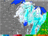
AIRMETs: I don't have the text any more, but here's the icing airmet graphic:

Drat. The stupid ADDS thing is too smart for its own good - It's continuously reloading the icing forecast map, so I don't have the "old" one any more. IIRC it was showing from 5% to 25% probability along the route, with higher probabilities down in northern Illinois (well south of our northeasterly route).
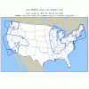
Radar:

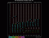
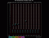
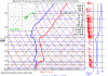
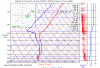
OK, here's the Skew-T's:
Madison:

Sheboygan:

So... Do you go, or not? What do you expect to see?
The mission: Fly an Archer from KMSN to KSBM to pick up the 182 from its annual, and ferry it back. 2 pilots in the Archer on the way up, one in each plane on the way back. Departure at MSN 2100Z, returning by 00Z.
Here's the weather as it looked when I was attempting to make the Go/No-Go decision:
FA:
CHIC FA 241946 COR
SYNOPSIS AND VFR CLDS/WX
SYNOPSIS VALID UNTIL 251400
CLDS/WX VALID UNTIL 250800...OTLK VALID 250800-251400
ND SD NE KS MN IA MO WI LM LS MI LH IL IN KY
.
SYNOPSIS...LOW PRES CNTR 20Z OVR NERN LWR MI-NRN LH FCST MOV
RPDLY ENE INTO CANADA BY 00Z. HI PRES RIDGE 20Z CNTRD OVR NERN
KS-NWRN MO FCST MOV EWD INTO NERN IL-NWRN IN BY 14Z. LOW PRES
TROF DVLPG DURG PD ALG ERN SLPS ROCKIES FROM MT-ERN NM.
.
WI
WRN...BKN030 BKN080. TOPS FL180. BECMG 2100 SCT030. 05Z SKC.
OTLK...VFR.
ERN...OVC010-020. TOPS FL200. OCNL VIS 3-5SM SCT -SHSN. BECMG
2201 SCT030 BKN060. TOPS FL180. 04Z SCT035. OTLK...VFR.
TAFs:
KMSN 241824Z 2418/2518 28011G18KT 5SM -SN BR OVC010
TEMPO 2418/2419 3/4SM -SN BLSN BR OVC008
FM241900 28012G20KT P6SM OVC015
TEMPO 2419/2421 3SM -SHSN BR OVC010
FM242100 28012G21KT P6SM OVC030
FM250000 28012G21KT P6SM BKN060
FM250200 28012KT P6SM SKC
FM251000 26005KT P6SM SKC
FM251600 18008KT P6SM SKC
KGRB 241727Z 2418/2518 29005KT 1 1/2SM -SN BR OVC007
TEMPO 2418/2422 1/2SM SN FZFG VV004
FM242200 27010G16KT 3SM -SN BR SCT008 OVC015
TEMPO 2422/2424 1 1/2SM -SN BR OVC008
FM250000 28012G20KT 6SM -SHSN SCT015 BKN035
FM250300 27010KT P6SM SCT035
FM250800 26005KT P6SM SKC
FM251500 21006KT P6SM SCT100 SCT200
(yes, I know the GRB TAF is technically irrelevant, but it can be good to compare with the FA.)
METARs:
KMSN 241953Z 28013G21KT 5SM -SN OVC019 M05/M09 A2972 RMK AO2 SLP075 P0000 T10501089
KSBM 241953Z AUTO 29009KT 1 1/2SM -SN BR FEW011 BKN014 OVC018 M01/M03 A2960 RMK AO2 SLP034 P0000 T10111028
KSBM 241953Z AUTO 29009KT 1 1/2SM -SN BR FEW011 BKN014 OVC018 M01/M03 A2960 RMK AO2 SLP034 P0000 T10111028
PIREPs:
MSN UA /OV MSN180005 /TM 1851 /FL033 /TP CRJ2 /SK OVC020-TOP033 /RM HZ LYRS ABV
UGN UA /OV UGN /TM 1855 /FLUNKN /TP C550 /SK OVC007 /IC NEG /RM RWY 23 BRAG /TA UNKN
MOP UA /OV HIC270015/TM 1858/FL060/TP BE58/TA M06/IC LGT RIME
ORD UA /OV ORD310005 /TM 1901 /FL072 /TP CRJ7 /SK OVC014-TOP072 /TA M09 /IC MOD RIME
AZO UA /OV AZO270010 /TM 1927 /FL026 /TP E145 /TA M02 /IC LGT RIME 080-026 /RM IMC 080-026
ARP UAL614 4159N 08754W 1937 F180 TB LT-MOD CHOP
AIRMETs: I don't have the text any more, but here's the icing airmet graphic:
Drat. The stupid ADDS thing is too smart for its own good - It's continuously reloading the icing forecast map, so I don't have the "old" one any more.
IIRC it was showing from 5% to 25% probability along the route, with higher probabilities down in northern Illinois (well south of our northeasterly route).Radar:
OK, here's the Skew-T's:
Madison:
Sheboygan:
So... Do you go, or not? What do you expect to see?
Attachments
Last edited: