azure
Final Approach
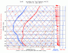
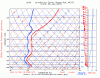
Lately I've been looking for opportunities to get experience in actual IMC, which are few and far between in winter around the Great Lakes. I just noticed that the forecast sounding between 900mb and about 750mb, for my home field tomorrow at from about 19Z on, looks a lot like the upper parts of many Skew-Ts when there are high cirrus clouds, which are usually glaciated. The T and DP curves parallel each other but are usually a few degrees apart. Now the skew-Ts for nearby airports don't look like this and some show the T and DP curves actually touching, so maybe this is due to something else, such as air that isn't quite saturated to the point of condensation, or even a model artifact...  But these temperatures are so cold, in the mid -20s by 5000 MSL or so that it's hard to imagine there's much liquid water in any clouds that will be up there. Yes I know -- the theoretical limit is still colder, -40. But what are the chances of encountering structural icing in clouds this cold?
This is probably going to remain a theoretical "what if" kind of question unless I can be really sure the clouds are completely glaciated. I don't fly a FIKI bird and at these temperatures, I don't really have an "out" unless I can get on top for long enough to sublimate the ice, and then get back down without going through the nasty stuff.
But these temperatures are so cold, in the mid -20s by 5000 MSL or so that it's hard to imagine there's much liquid water in any clouds that will be up there. Yes I know -- the theoretical limit is still colder, -40. But what are the chances of encountering structural icing in clouds this cold?This is probably going to remain a theoretical "what if" kind of question unless I can be really sure the clouds are completely glaciated. I don't fly a FIKI bird and at these temperatures, I don't really have an "out" unless I can get on top for long enough to sublimate the ice, and then get back down without going through the nasty stuff.