Funny dotted routes on Canada VNC charts?

eshazen

Pre-Flight
Joined
Mar 19, 2015
Messages
63
Location
Brookline, MA
Display Name

Display name:
Eric
Plotting a flight into Canada. I've been perusing the VNC charts on fltplan. I see a lot of dotted blue routes with diamond symbols which look like they might be suggested VFR routes. I don't have a paper chart with the legend to check. Anyone know what they are? Example below

chart.png
 

Attachments

  • chart.png
    chart.png
    684.3 KB · Views: 13
They are recommended VFR routes. They follow valleys that have highways, usually.
 
Excellent, thanks. Now I can continue dreaming about flying my Archer from the Boston area up to Anchorage to visit my sister:)
 
Plotting a flight into Canada. I've been perusing the VNC charts on fltplan. I see a lot of dotted blue routes with diamond symbols which look like they might be suggested VFR routes. I don't have a paper chart with the legend to check. Anyone know what they are? Example below

chart.png
I've done that trip from Las Vegas to Anchorage. The blue diamond routes are recommended VFR flyways. That one going north from Mackenzie is "The Ditch" , it's a long way with not much along the way to Watson Lake. Know your fuel burn, Mackenzie is the last fuel stop before Watson Lake. Coming from Boston, you'll be further east and can pick up fuel and fly along the Al-Can Hwy and skip the ditch. There were forest fires in the ditch when I went through, so I stayed out of it.
 
They used to be beer-bottle shaped. Til Transport Canada got all PC about things.
 
I recently bought a couple of Canada VNCs mostly so I would have the legend. I tried to scan it but it was blurry, and now they're in the bottom of my flight bag. But reading through the blur, this symbol is labeled "VFR Route. See TC AIM AIR 2.13" The Transport Canada Aeronautical Information Manual, Airmanship section 2.13, says this (emphasis supplied):

2.13 FLIGHT OPERATIONS IN MOUNTAINOUS AREAS

The importance of proper training, procedures and pre-flight planning when flying in mountainous regions is emphasized.

In the Pacific area, the combined effect of the great mountain system and the adjacent Pacific Ocean lead to extremely changeable weather conditions and a variety of weather patterns. Some of the factors to be taken into consideration regarding the effect on aircraft performance when operating under these conditions include the following:

(a) elevation of the airport;

(b) temperature and pressure;

(c) turbulence and wind effect; and

(d) determination of safe takeoff procedures to ensure clearance over obstacles and intervening high ground.

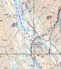
In the western mountainous region VFR routes may be marked by diamonds on visual navigation charts. The routes are marked for convenience to assist pilots with pre-flight planning. The diamond marks do not imply any special level of facilities and services along the route. Pilots are cautioned that the use of the marked routes does not absolve them from proper pre-flight planning or the exercising of good airmanship practices during the proposed flight. Alternative unmarked routes are always available, the choice of a suitable route for the intended flight and conditions remains the sole responsibility of the pilot-in-command.
 
Back
Top