Somedudeintn
Cleared for Takeoff
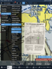
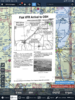
See images attached below. I used the MapTiler program to make custom mbtiles files for Foreflight.
The only way I know how to put them in foreflight is to send the files to your email and then open in foreflight. They will then be available as a map overlay.
I make no claims to the accuracy of these and accept no responsibility for you not looking out the window and staring at your iPad during the arrival.
https://drive.google.com/open?id=1n2FVXwtNDTLENvNxfckEgYyhm0F7kpRz
")