jwyatt
Pre-Flight
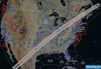
My wife and I were talking eclipse last night, and I couldn’t easily find a Foreflight custom layer for this one, like I found in 2017. So I made one. Sharing in case it may be of use to anyone else. The centerline is drawn, and 30-second bands of duration (starts with purple at 4:00+).
Data from https://svs.gsfc.nasa.gov/5073, with some massaging and colors to make it pretty.
Data from https://svs.gsfc.nasa.gov/5073, with some massaging and colors to make it pretty.