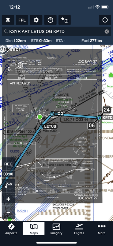
Have VOR/DME, but no GPS in airplane. Would like to plan a theoretical flight from Syracuse (KSYR) to Potsdam (KPTD). KPTD has no instrument approaches that I can use. How does the routing work? I would think that filing to the Massena VOR (MSS) is closest and then fly VFR to KPTD, but the low alt IFR chart states to radial to the VOR is unusable. Could I file to the LETUS intersection? Does IFR then get terminated at that point unless weather is not VFR to KPTD and I need to divert? Regardless I know that I would need to file an alternate. Just looking for the best "by the book" answer for dealing with this situation. Thanks.
Hard to say what the “best by the book” answer is. Filing ‘short’ to and getting a clearance ‘To’ LETUS should work just fine. You could also file and get a clearance to KPTD via ...LETUS Direct. You would end up cancelling before you got Potsdam either way. You might even get a Cruise clearance. Those don’t seem to be used much but ‘by the book’ they are there. Here’s some book references.
CRUISE in the Pilot/Controller Glossary.
AIM 4-4-3 d. 3.
FAR 91.177 (a) (2) tells you what the minimum altitude is
The Controllers book says this:
a. Altitude to maintain or cruise. When issuing cruise in conjunction with an airport clearance limit and an unpublished route will be used, issue an appropriate crossing altitude to ensure terrain clearance until the aircraft reaches a fix, point, or route where the altitude information is available to the pilot. When issuing a cruise clearance to an airport which does not have a published instrument approach, a cruise clearance without a crossing restriction may be issued.
PHRASEOLOGY−
MAINTAIN/CRUISE (altitude). MAINTAIN (altitude) UNTIL (time, fix, waypoint),
or
(number of miles or minutes) MILES/MINUTES PAST (fix, waypoint).
CROSS (fix, point, waypoint), or
INTERCEPT (route) AT OR ABOVE (altitude), CRUISE (altitude).
NOTE−
1. The crossing altitude must assure IFR obstruction clearance to the point where the aircraft is established on a segment of a published route or instrument approach procedure.
2. When an aircraft is issued a cruise clearance to an airport which does not have a published instrument approach procedure, it is not possible to satisfy the requirement for a crossing altitude that will ensure terrain clearance until the aircraft reaches a fix, point, or route where altitude information is available to the pilot. Under those conditions, a cruise clearance without a crossing restriction authorizes a pilot to determine the minimum IFR altitude as prescribed in 14 CFR Section 91.177 and descend to it at pilot discretion if it is lower than the altitude specified in the cruise clearance.
")