You are using an out of date browser. It may not display this or other websites correctly.
You should upgrade or use an alternative browser.
You should upgrade or use an alternative browser.
Flight separation chart
- Thread starter JoeDeBoer
- Start date
murphey
Touchdown! Greaser!
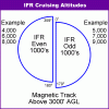
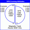
Where might find a flight separation chart? FAR/AIM ? Online? I know it's west is 3500ft AGL and east is 4500ft AGL right? But is there a chart? Thanks!
It's not a chart and it's not two specific altitudes.....for magnetic course VFR flights, even + 500 going west, odd + 500 going east.
14 CFR 91.159
HighFlyingA380
Cleared for Takeoff
Attachments
dukeblue219
Line Up and Wait
Since nobody else mentioned it, I'll note that those cruise altitudes are MSL, not AGL, though they are really only required when you're above 3000' AGL.
It sounds trivial, but I trained in Atlanta which is right about 1000' MSL on the surface. So, if you were truly flying east at 3500' AGL you'd be at 4500' MSL and running right into traffic properly flying west at that altitude. Along those same lines, even if you were flying east at 3500' MSL you would still want to keep your eyes open because since you're not quite 3000' AGL yet traffic may be going in all directions around you.
It sounds trivial, but I trained in Atlanta which is right about 1000' MSL on the surface. So, if you were truly flying east at 3500' AGL you'd be at 4500' MSL and running right into traffic properly flying west at that altitude. Along those same lines, even if you were flying east at 3500' MSL you would still want to keep your eyes open because since you're not quite 3000' AGL yet traffic may be going in all directions around you.
HighFlyingA380
Cleared for Takeoff
Whoops...
Last edited:
MAKG1
Touchdown! Greaser!
- Joined
- Jun 19, 2012
- Messages
- 13,411
- Location
- California central coast
- Display Name
Display name:
MAKG
Since nobody else mentioned it, I'll note that those cruise altitudes are MSL, not AGL, though they are really only required when you're above 3000' AGL.
It sounds trivial, but I trained in Atlanta which is right about 1000' MSL on the surface. So, if you were truly flying east at 3500' AGL you'd be at 4500' MSL and running right into traffic properly flying west at that altitude. Along those same lines, even if you were flying east at 3500' MSL you would still want to keep your eyes open because since you're not quite 3000' AGL yet traffic may be going in all directions around you.
And more importantly, if you're flying along at a course of 181, someone may be coming at you at 359, at the same altitude. That's very close to head-on.
murphey
Touchdown! Greaser!
Since nobody else mentioned it, I'll note that those cruise altitudes are MSL, not AGL, though they are really only required when you're above 3000' AGL.
It sounds trivial, but I trained in Atlanta which is right about 1000' MSL on the surface. So, if you were truly flying east at 3500' AGL you'd be at 4500' MSL and running right into traffic properly flying west at that altitude. Along those same lines, even if you were flying east at 3500' MSL you would still want to keep your eyes open because since you're not quite 3000' AGL yet traffic may be going in all directions around you.
Excellent point!