You are using an out of date browser. It may not display this or other websites correctly.
You should upgrade or use an alternative browser.
You should upgrade or use an alternative browser.
Flight Display 360 or 180 View
- Thread starter kontiki
- Start date
tehmightypirate
Line Up and Wait
Are you talking about the HSI?
MAKG1
Touchdown! Greaser!
- Joined
- Jun 19, 2012
- Messages
- 13,411
- Location
- California central coast
- Display Name
Display name:
MAKG
It's kinda ambiguous.
I find the 180 view much easier to read in an Aspen Evolution, 'cause the 360 is tiny. It works as long as I don't have any course reversals. Likely a problem IFR, but I only fly VFR.
I find the 180 view much easier to read in an Aspen Evolution, 'cause the 360 is tiny. It works as long as I don't have any course reversals. Likely a problem IFR, but I only fly VFR.
FastEddieB
Touchdown! Greaser!
- Joined
- Oct 14, 2013
- Messages
- 11,421
- Location
- Lenoir City, TN/Mineral Bluff, GA
- Display Name
Display name:
Fast Eddie B
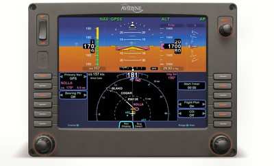
I played with the different views on the Avidyne PFD in my Cirrus, and my Garmin 496.
Always quickly returned to the 360°.
When reporting where I am relative to where I'm going, my personal "kludge" is to look at the tail of the arrow on the HSI.
Like here...

A glance at the arrow's tail tells me I'm arriving from the SE.
The small gain in view ahead with the "fan view" does not compensate for the loss of reciprocal heading, at least in my book:

I mean, I should already know where I'm coming from without that, but I've had too many cases of "Mature Onset Dyslexia" not to use every aid at my disposal! :wink2:
Always quickly returned to the 360°.
When reporting where I am relative to where I'm going, my personal "kludge" is to look at the tail of the arrow on the HSI.
Like here...

A glance at the arrow's tail tells me I'm arriving from the SE.
The small gain in view ahead with the "fan view" does not compensate for the loss of reciprocal heading, at least in my book:

I mean, I should already know where I'm coming from without that, but I've had too many cases of "Mature Onset Dyslexia" not to use every aid at my disposal! :wink2:
Last edited:
tehmightypirate
Line Up and Wait
I'm with Eddie, I see no advantage and you loose the ability to quickly find reciprocals to your heading.
kontiki
Cleared for Takeoff
- Joined
- May 30, 2011
- Messages
- 1,121
- Display Name
Display name:
Kontiki
I asked the question is because I have an Aspen EFD1000. I’m trying to get ready for approach practice and IFR use.
The EFD underlays flight plan data and various symbol from the GNS 430W under the heading ring, and that layer zooms in or out.
There is a 360/180 toggle button on the bezel, the declutter settings are buried in the setup menus.
The 360 ring can get quite busy at times.
I was thinking that I should maybe customize the 180 ring for IFR enroute, and the 360 ring for approach use. I get a deviation needle with both rings.
To that end, I’m thinking:
360 ring should be set for airports off, Intersections & NDBs off
180 ring could show everything, maybe I can get rid of the NDBs with a declutter level.
I've still got a couple more things to check out.
FastEddieB
Touchdown! Greaser!
- Joined
- Oct 14, 2013
- Messages
- 11,421
- Location
- Lenoir City, TN/Mineral Bluff, GA
- Display Name
Display name:
Fast Eddie B
Whatever works - it's nice to have options.
Kind of like "North Up" vs. "Track Up", it's a matter of personal preference and you can't go wrong either way.
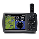
On my 496, I've repeatedly tried the full screen map with the superimposed "heading indicator" to get the benefit of the larger map view. Many Garmins I see in the field are set up like that...

But I always go back to the split screen with full "HSI".

(Looking at that image again, I'm reminded that even VFR in my Light Sport I use the faux "glideslope" to help manage descents. Not sure if it shows in other views, and certainly off topic to your question - sorry)
Anyway, no right and wrong here - play with both. And you might find you like one for enroute and one for approach. For consistency, I might not like going back and forth, but let us know what ends up working out for you!
Small point - on most of these, the compass rose is showing ground track, not heading, though some may be plumbed to remote compasses and such for actual heading info, I assume. I recall the Avidyne allowed you to choose among several options.
Kind of like "North Up" vs. "Track Up", it's a matter of personal preference and you can't go wrong either way.
On my 496, I've repeatedly tried the full screen map with the superimposed "heading indicator" to get the benefit of the larger map view. Many Garmins I see in the field are set up like that...

But I always go back to the split screen with full "HSI".

(Looking at that image again, I'm reminded that even VFR in my Light Sport I use the faux "glideslope" to help manage descents. Not sure if it shows in other views, and certainly off topic to your question - sorry)
Anyway, no right and wrong here - play with both. And you might find you like one for enroute and one for approach. For consistency, I might not like going back and forth, but let us know what ends up working out for you!
Small point - on most of these, the compass rose is showing ground track, not heading, though some may be plumbed to remote compasses and such for actual heading info, I assume. I recall the Avidyne allowed you to choose among several options.
Last edited:
Marauder
Cleared for Takeoff
- Joined
- Oct 24, 2012
- Messages
- 1,463
- Display Name
Display name:
Marauder
I asked the question is because I have an Aspen EFD1000. I’m trying to get ready for approach practice and IFR use.
The EFD underlays flight plan data and various symbol from the GNS 430W under the heading ring, and that layer zooms in or out.
There is a 360/180 toggle button on the bezel, the declutter settings are buried in the setup menus.
The 360 ring can get quite busy at times.
I was thinking that I should maybe customize the 180 ring for IFR enroute, and the 360 ring for approach use. I get a deviation needle with both rings.
To that end, I’m thinking:
360 ring should be set for airports off, Intersections & NDBs off
180 ring could show everything, maybe I can get rid of the NDBs with a declutter level.
I've still got a couple more things to check out.
Another thing you can use is the auto range feature. Turn it on by holding the + or - button until you see an "A" symbol next to the range field. What this does is keeps the course line and next waypoint on the moving map in scale. As you go for waypoint to waypoint, only the next one is displayed and not the entire flight plan.
Piloto
Line Up and Wait
- Joined
- Oct 16, 2011
- Messages
- 989
- Display Name
Display name:
Piloto
The 360 view is very handy when coming on an extended downwind with the runway behind. It helps you maintain aligment with the runway specially when turning base. When doing a downwind approach I set the OBS to runway course so I can see my alignment to the approach path
José
José
Last edited:
MAKG1
Touchdown! Greaser!
- Joined
- Jun 19, 2012
- Messages
- 13,411
- Location
- California central coast
- Display Name
Display name:
MAKG
Of course, if you're flying a VFR pattern, you could look out the window.
