FF: differing ETEs

Let'sgoflying!

Touchdown! Greaser!
Joined
Feb 23, 2005
Messages
21,872
Location
west Texas
Display Name
Dave Taylor
Home Airfield
KMRF
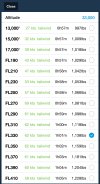
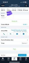
FF gives an ete at the top of the flight plan page, and another in altitude selection dropdown.
For tomorrow’s flight they are in significant disagreement.
Would the one in the altitude selection always be more accurate?
 
That sounds like a phone call to Foreflight…either their software needs fixing or you’re not understanding how those numbers are derived. I’m sure they’d be happy to help resolve either issue.
 
I’m not a FiveFlight user but I wonder if the documentation could shed light on whether one of the fields may be a no wind or default altitude condition while the other takes winds aloft or other data into consideration.

This is an instance where manually calculating the timing could be helpful, but definitely worth finding out how the sausage is being made.
 
Okay, I'm curious... Where exactly are you looking at these ETEs? You said the Flights page, so I'm assuming that is after a Briefing with the correct Departure time and Altitude. But what is the other Dropdown? Is this in the Altitude selection on the Map page or somewhere else where FF is using current or historical winds? If it is the Map page, check the time shown in the dropdown. Then go to the Flights page and use the Send To and send that Flight info to the Map and then compare the NavLogs in Flights and on the Map page? Are they accurate/matching? (You can also use the Pack, but sense you mentioned the Flights page, I'd use it to Brief and compare.)

If it is still off, it will be interesting to hear which exact places are showing different times.
 
It must have been a glitch b/c when I check it now, they are within a few minutes of each other.
I had been packing and briefing the whole time to make sure the data was updated.

One is the top of the first flight plan page, it has Dist/ETE/ETA/Flight Fuel/Wind
The other is ~ half way down the first page, Cruise Altitude...(select one)> if you click on the arrow you can see all the altitudes, wind, ETE, Fuel reqd.

Thanks,
I''ll be monitoring upcoming flights.
Does anyone think there is any particular use to having the flight plan split up into two pages? There are multiple duplications between the two pages, I don't get it.
 
Can you post some screen shots of where these numbers are? There are too many options to give a straight answer otherwise.
 
Sure
As noted, they now agree.
 

Attachments

  • IMG_2058.jpeg
    IMG_2058.jpeg
    403.5 KB · Views: 13
  • IMG_2057.jpeg
    IMG_2057.jpeg
    277.7 KB · Views: 13
I did a little more digging and came up with this from FF.

Winds and ETEs may be different on different pages:
  • Time-Based Data: The winds shown on different pages may represent different forecast periods. For example, winds on the Maps page show a forecast for an upcoming period, while the Wind Chart in a briefing shows a snapshot at the estimated time of departure.
  • Data Update Frequency: Data can be updated at different rates. Winds data, for instance, is refreshed every 2 minutes, but other data points might have different refresh rates.
  • Display Methodology: The display of winds can also vary. For example, some winds data is based on True North, while runway headings are based on Magnetic North, which can cause apparent discrepancies in crosswind components that require a separate calculation to reconcile.
  • Route Segmentation: For long flights, ForeFlight can break a route into smaller segments to calculate wind effects more accurately, which can lead to slight variations in the data compared to less-segmented calculations.
 
Back
Top