You are using an out of date browser. It may not display this or other websites correctly.
You should upgrade or use an alternative browser.
You should upgrade or use an alternative browser.
Evening weather W Tx
- Thread starter Let'sgoflying!
- Start date
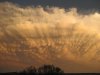
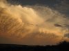
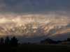
Boy,,, When you see those you make a 180,,,, darn fast too.

Diana
Final Approach
Wow, Dave, those are impressive photos! Did you get any rain from the outskirts of the storm?
Let'sgoflying!
Touchdown! Greaser!
dry here, Diana!
we were 1sm & vv200 F this am!
we were 1sm & vv200 F this am!
vontresc
En-Route
dry here, Diana!
we were 1sm & vv200 F this am!
In Marfa? It's actually wet down there? I remember 40deg C temp/dew point spreads when I was there in April.
Let'sgoflying!
Touchdown! Greaser!
we had a good and wet summer....25 mi N of Marfa. (the moisture has been spotty) Should be heading into dry season shortly.....with scads of combustible biomass
tonycondon
Gastons CRO (Chief Dinner Reservation Officer)
beautiful pictures!
Ghery
Touchdown! Greaser!
- Joined
- Feb 25, 2005
- Messages
- 10,903
- Location
- Olympia, Washington
- Display Name
Display name:
Ghery Pettit
beautiful pictures!
When viewed from the ground and not out the windscreen.
Let'sgoflying!
Touchdown! Greaser!
feel free to share or add to educational presentations Scott
I can also provide the originals to anyone although they are not much better.
I can also provide the originals to anyone although they are not much better.
feel free to share or add to educational presentations Scott
I can also provide the originals to anyone although they are not much better.
I am all ears too. One can never learn enough about weather..
Ben.
Thanks. These are excellent pics.
He has good material to work with, Scott.
---
I also appreciate anything you share. Thanks.
TangoWhiskey
Touchdown! Greaser!
WOW, Dave, that's amazing. The mother ship showed up.
PLEASE submit those to the Weather Channel; I bet you'll see them on TV:
http://community.weather.com/community/choosefile?from=hp_dwp
PLEASE submit those to the Weather Channel; I bet you'll see them on TV:
http://community.weather.com/community/choosefile?from=hp_dwp
TangoWhiskey
Touchdown! Greaser!
"Center, Bellanca 03V is going to need about 90 degrees right for about 200 miles"
Let'sgoflying!
Touchdown! Greaser!
Troy if you are a member, go ahead. "I grant you right to any credit on the WC forum." (I'd give you full ownership, but that might screw up a previous post!)
TangoWhiskey
Touchdown! Greaser!
Troy if you are a member, go ahead. "I grant you right to any credit on the WC forum." (I'd give you full ownership, but that might screw up a previous post!)
Done! I'll let you know when they post... they have to go through a manual review first (that's how they keep the pictures relevant).
TangoWhiskey
Touchdown! Greaser!
Check out this photo of a storm same day in Florida; looks like an atom bomb went off:
http://www.weather.com/outlook/phot...7B-8E9F5DCF7378?from=photos_browse_recent_day
http://www.weather.com/outlook/phot...7B-8E9F5DCF7378?from=photos_browse_recent_day
Let'sgoflying!
Touchdown! Greaser!
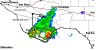
here is what the NWS said about it
DISCUSSION...
LATEST SFC ANALYSIS FRONT HAS STALLED OVER THE BIG BEND...AND
EXTENDS E-NE ACROSS TEXAS TO KSHV...AND WILL BE THE FOCUS OF
CONVECTION 1ST PD. UPPER TROUGH OVER SRN CA WILL BEGIN MOVING EAST
TODAY...DRAWING A WARM FRONT INTO WEST TEXAS AS LEESIDE TROUGHING
STRENGTHENS. AS WARM SECTOR MOVES NORTH...INCREASING WESTERLY FLOW
WEST OF THE FA WILL BEGIN SHARPENING UP A DRYLINE OVER THE HIGHER
TERRAIN BY 00Z. MODELS DIFFER ON HOW FAR NORTH THE WARM FRONT GETS
THIS AFTERNOON...WITH THE NAM ADVANCING IT ONLY AS FAR AS
KFST...WHILE THE GFS TAKES IT TO THE WESTERN LOW ROLLING PLAINS BY
00Z THURSDAY. LATEST ECMWF ALSO TAKES IT FURTHER NORTH THAN THE
NAM...SO WE/LL LEAN TOWARD THE GFS/ECMWF SOLUTION. CONVERGENCE
ALONG THIS FEATURE WILL RESULT IN INCREASING CHANCES OF CONVECTION
INTO TONIGHT...AIDED BY A 45+KT LLJ DEVELOPING OVER THE EASTERN
ZONES AFTER 00Z. FORECAST SOUNDINGS SHOW DEEP LAYER SHEAR AND
MID-LVL LRS SUPPORTIVE OF SUPERCELLS...W/HAIL BEING THE MAIN
THREAT. 0-3KM/0-1KM HELICITIES AND LOW LCLS ALSO HINT AT A TORNADO
THREAT...AND THIS BEARS WATCHING.
Dr. Bill
Pre-takeoff checklist
Good morning, Dave.
I've been covering the ER in Ballinger (E30, near San Angelo) since yesterday a.m. We got quite a bit of rain/hail/wind out of the edge of some front; and this morning it's about 65 degrees outside!
Hope your morning is as well! It's all suddenly so green...
I've been covering the ER in Ballinger (E30, near San Angelo) since yesterday a.m. We got quite a bit of rain/hail/wind out of the edge of some front; and this morning it's about 65 degrees outside!
Hope your morning is as well! It's all suddenly so green...
TangoWhiskey
Touchdown! Greaser!
Here's your pics, Dave, on Weather Channel.
http://www.weather.com/outlook/phot...-BCC7-DA81609EB051?from=photos_browse_weather
http://www.weather.com/outlook/phot...-8625-DF47416DB29E?from=photos_browse_weather
And here are some more shot in Alpine by other users from the same storm:
http://www.weather.com/outlook/phot...-968B-9BE4974A9BD7?from=photos_browse_weather
http://www.weather.com/outlook/phot...-9697-813006E915C9?from=photos_browse_weather
http://www.weather.com/outlook/phot...-917D-ED41DBC28AA4?from=photos_browse_weather
http://www.weather.com/outlook/photo/member?member=RachelB&from=photo_detail_weather
Jeanie
Pattern Altitude
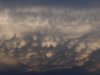
Hi Dave, I looked out the porch door and saw the same clouds - ran back in and got my camera too. Then Kevin and I drove into town to see if we could see the anvil above the leading wing of it but it was moving so fast at the time that I never did get to see above it. We watched it for a long time and I saw the mammatus form and dissipate and then the whole thing just sort of quit and backed up just over our house. No hail here though or precip either. I've never seen anything like it out here. Stacked lenticulars and huge black wall clouds sure but not that stuff. I was very glad that we had returned from Santa Fe, NM a couple of days before. Julie can't outrun anything but sometimes an 18 wheeler on the interstate .....
For those of you who don't know - Julie is my name for my Cessna 152
..... For those of you who don't know - Julie is my name for my Cessna 152
Let'sgoflying!
Touchdown! Greaser!
Hi Jean
Someone in Alpine put it on youtube as well. Never did hear of reports from south county - bet someone got pounded.
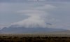
Here is one of the Haystacks (local hill) looks volcano-esque - a few weeks ago..
admission: heavily modified to highlight the clouds.
Someone in Alpine put it on youtube as well. Never did hear of reports from south county - bet someone got pounded.
Here is one of the Haystacks (local hill) looks volcano-esque - a few weeks ago..
admission: heavily modified to highlight the clouds.
Attachments
tonycondon
Gastons CRO (Chief Dinner Reservation Officer)
almost looks like some wave there dave...
Everskyward
Experimenter
- Joined
- Mar 19, 2005
- Messages
- 33,448
- Display Name
Display name:
Everskyward
Let'sgoflying!
Touchdown! Greaser!
Nice shots!