You are using an out of date browser. It may not display this or other websites correctly.
You should upgrade or use an alternative browser.
You should upgrade or use an alternative browser.
Denver fires, mandatory evacuations
- Thread starter TangoWhiskey
- Start date

murphey
Touchdown! Greaser!
It really depends where you are. I live east-northeast of the fires but more than
30 miles away. Sky is orangey, definite aroma of BBQ charcoal fires...
Folks on the west side of town are getting substantial smoke. In the area of the fires? Mandatory evacs have begun.
Unfortunately the high winds are forecast until late this evening. Even DIA has problems with the high winds and it's another 15 miles or so NE of me.
denverpilot
Tied Down
I've been posting photos in the Colorado weekend thread from Saturday.
The fires are in the foothills and the wind hasn't laid down after sunset which is really bad.
One of the large fires is a reigniting of a prescribed burn on Friday of last week. Some powers that be are going to have some very unhappy people to answer to on that one.
I'm on a low ridge West of KAPA by about 4 nm. The smoke from 20-25 miles away can be seen in car headlights and the whole neighborhood smells like a campfire.
I posted this stuff earlier in the other thread but here it is again.
The official weather observer at KAPA hasn't been outside to SMELL the smoke, they report the "plume" as "distant" I'm the second METAR below. They're IN the plume. Those aren't clouds.")


The moon and Venus are quite orange from my backyard.
If you check my Facebook or Twitter feeds, one of the local news photogs posted a cool "shot" of the Doppler RADAR showing the smoke plume extending out past Ft. Morgan. I re-tweeted/posted to FB.
Wind is expected to lay down some overnight. Everything on the Front Range is sitting at single-digit humidities and the next weather system even capable of precipitation isn't due until Monday of next week at the earliest.
The fires are in the foothills and the wind hasn't laid down after sunset which is really bad.
One of the large fires is a reigniting of a prescribed burn on Friday of last week. Some powers that be are going to have some very unhappy people to answer to on that one.
I'm on a low ridge West of KAPA by about 4 nm. The smoke from 20-25 miles away can be seen in car headlights and the whole neighborhood smells like a campfire.
I posted this stuff earlier in the other thread but here it is again.
The official weather observer at KAPA hasn't been outside to SMELL the smoke, they report the "plume" as "distant" I'm the second METAR below. They're IN the plume. Those aren't clouds.
The moon and Venus are quite orange from my backyard.
If you check my Facebook or Twitter feeds, one of the local news photogs posted a cool "shot" of the Doppler RADAR showing the smoke plume extending out past Ft. Morgan. I re-tweeted/posted to FB.
Wind is expected to lay down some overnight. Everything on the Front Range is sitting at single-digit humidities and the next weather system even capable of precipitation isn't due until Monday of next week at the earliest.
denverpilot
Tied Down
http://denver.cbslocal.com/2012/03/26/lower-north-fork-fire/
Looks like one of the many fires has been confirmed to have taken some houses. Sad.
Looks like one of the many fires has been confirmed to have taken some houses. Sad.
denverpilot
Tied Down
fgcason
En-Route
Is there anything showing where these fires are actually at besides photos of fire and smoke from random unidentified locations. Foothills and hilly terrain SW of denver and burned 4.5 square miles is about as precise as "somewhere near mountains in colorado."
denverpilot
Tied Down
The local news stations have some weak maps up.
Heard on Elk Creek Fire Command/Operations channel last night that a FEMA Type I incident management team had been ordered but might take a day plus to arrive.
(That's a $45K phone call for just the first day of work and they show up with enough staff to completely take over all of the Incident Command System roles, and a full staff and all the necessary gear. It's impressive to watch a Type I team set up.)
They'll show up with fast access to satellite imagery, and now that the winds have died down, the Sheriff will get a spotter up in an aircraft to look at the fire's extent this morning, I'd assume.
If things go like they usually do, accurate maps will be scarce until around the noon news press releases but, I'm sure someone stayed up most of the night at the ICP making at least a rudimentary map from ground reports, that they'll start today's attack plan from. A sanitized version of that map (without structure damage information) will be shared with the Press for their morning shows.
Already saw a tweet from the local TV photog who flies in the only remaining helicopter, that they're about to launch for the morning but need to wait for daylight to head west toward the fire.
They'll probably give fire edge info and GPS coordinates of any hot spots they're seeing/filming to the Sheriff also, until they're chased off by any TFRs that'll get slapped up here soon for the fire bombers if the bomber crews are ordered and agree the weather is flyable.
There's a definite feel of "no need to rush and get anyone hurt" on the dispatch frequencies so far. The feel is less frantic than the Boulder Fire. JeffCo sees a lot more of these and they sound like they're settling in for the long haul. This thing will be going for a while.
Elk Creek sounds grateful for all of the assistance they're getting, which is pretty typical around here.
Certain local crews and task forces of staff from surrounding and suburban agencies can start with pre-arranged "12 hour mutual aid" State payment guarantees, but one of the reasons to get a FEMA team rolling early in these is to also get the aid money liquid.
A volunteer department like Elk Creek stands no chance of being able to pay for crews for a two or three week fire.
(I'm looking forward to my ICS 400 class, can ya tell? I have done ICS 100, 200, 300, and 700 so far. Someday when I have more time I might do the Comm-L.)
Heard on Elk Creek Fire Command/Operations channel last night that a FEMA Type I incident management team had been ordered but might take a day plus to arrive.
(That's a $45K phone call for just the first day of work and they show up with enough staff to completely take over all of the Incident Command System roles, and a full staff and all the necessary gear. It's impressive to watch a Type I team set up.)
They'll show up with fast access to satellite imagery, and now that the winds have died down, the Sheriff will get a spotter up in an aircraft to look at the fire's extent this morning, I'd assume.
If things go like they usually do, accurate maps will be scarce until around the noon news press releases but, I'm sure someone stayed up most of the night at the ICP making at least a rudimentary map from ground reports, that they'll start today's attack plan from. A sanitized version of that map (without structure damage information) will be shared with the Press for their morning shows.
Already saw a tweet from the local TV photog who flies in the only remaining helicopter, that they're about to launch for the morning but need to wait for daylight to head west toward the fire.
They'll probably give fire edge info and GPS coordinates of any hot spots they're seeing/filming to the Sheriff also, until they're chased off by any TFRs that'll get slapped up here soon for the fire bombers if the bomber crews are ordered and agree the weather is flyable.
There's a definite feel of "no need to rush and get anyone hurt" on the dispatch frequencies so far. The feel is less frantic than the Boulder Fire. JeffCo sees a lot more of these and they sound like they're settling in for the long haul. This thing will be going for a while.
Elk Creek sounds grateful for all of the assistance they're getting, which is pretty typical around here.
Certain local crews and task forces of staff from surrounding and suburban agencies can start with pre-arranged "12 hour mutual aid" State payment guarantees, but one of the reasons to get a FEMA team rolling early in these is to also get the aid money liquid.
A volunteer department like Elk Creek stands no chance of being able to pay for crews for a two or three week fire.
(I'm looking forward to my ICS 400 class, can ya tell?
I have done ICS 100, 200, 300, and 700 so far. Someday when I have more time I might do the Comm-L.)denverpilot
Tied Down
Just heard. The morning "Presser" (Press Conference) is in 5 minutes at 06:30 local.
While the elected talking heads are getting their TV time, the news crews will be handed a press packet with the real info which will be getting quickly turned into pretty colored maps by the news and weather departments with those nice little fire icons and graphic animations. The ticker operators will cherry pick out the interesting statistics and those will start being added to the crawls. It'll be around 7:30 before the local outlets are all on the same virtual page.
While the elected talking heads are getting their TV time, the news crews will be handed a press packet with the real info which will be getting quickly turned into pretty colored maps by the news and weather departments with those nice little fire icons and graphic animations. The ticker operators will cherry pick out the interesting statistics and those will start being added to the crawls. It'll be around 7:30 before the local outlets are all on the same virtual page.
Let'sgoflying!
Touchdown! Greaser!
Fire bites. I recommend avoiding.
Thanks for the link.... Amazing stuff they can do nowadays
denverpilot
Tied Down
Looks like ol' "44" will be pressed into service...
http://cbsdenver.files.wordpress.com/2012/03/2012-03-27_10-07-50_567.jpg
http://cbsdenver.files.wordpress.com/2012/03/2012-03-27_10-07-50_567.jpg
gkainz
Final Approach
Looks like ol' "44" will be pressed into service...
http://cbsdenver.files.wordpress.com/2012/03/2012-03-27_10-07-50_567.jpg
Yep, he was taking off from KBJC as I was putting the Dakota away this morning around 10:30 am.
Wind has died down significantly - 5 knots on the surface but we got pounded with continuous moderate turbulence at 6500' leaving BJC heading north (lots of PIREPS "after" the fact!) so we ducked back down and scooted out to GXY. Not bad out there. I still don't know what caused it - no lennies, rotors or anything spelling out "Caution - Bumps!" but it was rough.
denverpilot
Tied Down
Maybe our butts aren't tuned for thermals yet this early in the season?
gkainz
Final Approach
Could be my butt is still running the winter tune. This was worse than typical summer thermals, tho. Bad enough I couldn't tune the radios.
I tried the CloudAhoy thing with the iPhone, but kept it in my pocket so all the maneuvering, steep turns, sim engine outs and stalls just went to "unknown maneuvering" classification.
GPS reliability got rated at 0%/0% ... might try putting it on the glare shield next time, or spring for a BadElf or similar.
This was worse than typical summer thermals, tho. Bad enough I couldn't tune the radios. I tried the CloudAhoy thing with the iPhone, but kept it in my pocket so all the maneuvering, steep turns, sim engine outs and stalls just went to "unknown maneuvering" classification.
GPS reliability got rated at 0%/0% ... might try putting it on the glare shield next time, or spring for a BadElf or similar.
denverpilot
Tied Down
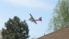
Here is a picture of the Neptune on it's way from KBJC to the Lower North Fork Fire this afternoon.
Nice shot.
Clark1961
Touchdown! Greaser!
- Joined
- Jun 7, 2008
- Messages
- 17,737
- Display Name
Display name:
Display name:
Maybe our butts aren't tuned for thermals yet this early in the season?
Shear layer - winds aloft are cooking along and the air in the Denver basin is just sitting around doing nothing. Not uncommon in the spring north of BJC. It's one thing the trained meteorologists frequently miss about turbulence on the lee side of the hills.
gkainz
Final Approach
makes sense, Clark. I did see some pretty fast winds reported but figured they were high enough (20k+) as to not make that big an impact.
denverpilot
Tied Down
Ahh yeah... I forgot we had the beginning of "inversion" season going against us too...
denverpilot
Tied Down
Gorgeous shots of the tanker base at KBJC today from Steve Nelson, one of the more prolific shooters in the Colorado Aviation Photographers group on Facebook...
https://www.facebook.com/media/set/?set=a.3695307265727.168878.1366685896&type=1
https://www.facebook.com/media/set/?set=a.3695307265727.168878.1366685896&type=1
Everskyward
Experimenter
- Joined
- Mar 19, 2005
- Messages
- 33,448
- Display Name
Display name:
Everskyward
Nice! I also really like this one which seems to be the one they are using in the online Denver Post for the fire story.

denverpilot
Tied Down
That's an incredible shot for trying to explain to folks how wind flows over and around mountains... look at that smoke lying in the little valleys... so cool!
(I hate to get excited about the photos since there's already two people dead and many without homes, but the photography really is incredible...)
(I hate to get excited about the photos since there's already two people dead and many without homes, but the photography really is incredible...)
denverpilot
Tied Down
The true depths of how bad a government cluster**** this is, is starting to show.
http://www.denverpost.com/news/ci_20272546
If it were anyone other than government employees who chose last Thursday -- in our dry conditions --- to do a prescribed burn that got this out of control and deadly, there'd be words like "gross negligence" and "manslaughter" being discussed.
At the very least a big fat fine.
Government immunity will mean no one will even be fired.
Certainly no Civil suits for those who lost their homes.
Our idiot governor announces today that he's banning all State prescribed burns.
Gee, you think? Good old Hickey... leading from the rear again.
And a dispatch office tired of hearing from nervous residents tells them to stop calling as the fire goes completely out of control? Awful.
That's a tough one, because people really are stupid, but ya think ya might ask a fire expert from Elk Creek Station 1 to go look, Jeffco?
You know, the wind was blowing and the humidity was 5%... Nothing bad ever happens in those conditions.
Doesn't common sense dictate giving the on-duty Elk Creek Chief a ring and letting him decide if you're starting to take extra call volume on it? They're a few minutes away via the Suburban or the brush truck stationed at Station 1. They'd have gone and looked.
I've been working with Elk Creek for years. They'd have been just fine with a "hey we're getting a lot of calls, could you guys take a look?" call-out. They all have homes up there.
Then again... Why wasn't Elk Creek already driving over to monitor when the burn was re-flaring in high winds.
Total cock-up.
Just wait till the state contracts out to a "consulting firm" to analyze their data so they can then say... Upon further investigation the fire was started by a hunter warming fire that was set last Nov.. and it could not have been started by the government employee that was first suggested..
:wink2:
ya just know it's coming....
:wink2:
ya just know it's coming....
Last edited:
TangoWhiskey
Touchdown! Greaser!
Last night's fire map:
http://maps.google.com/maps/ms?ie=U...477546,-105.233231&spn=0.185501,0.411987&z=11
http://maps.google.com/maps/ms?ie=U...477546,-105.233231&spn=0.185501,0.411987&z=11
denverpilot
Tied Down
http://kdvr.com/2012/04/04/911-calls-reveal-panic-misinformation-as-lower-north-fork-fire-spread/
If they'd never have called 911 and just gotten out, they'd have had a chance. Husband found dead in the house, wife found dead in the driveway.
This elderly couple that was killed by inept bureaucrats who approved the prescribed burn in the dryest March on record without even filling out their own monitoring plan documents, let alone thinking about it, and dispatchers who didn't react appropriately to the reports of a firestorm.
In any other business there'd be pending manslaughter charges and one hell of a Civil suit for Gross Negligence. Government is immune.
Not a single person even fired. Maybe the underling State Forestry guy someday.
Our hapless Governor won't be touched. He will continue to lead from the rear and take no accountability for his staff, their policies, or their actions.
RIP. Your government will pretend they don't know how forest fires worked prior to this day and publish some new guidelines for prescribed burns. They'll probably even offer certification classes in how to fill out the forms.
Don't bother picking up the phone or waiting for a broken reverse 911 system call if your house is in the path of a forest fire and there are 79 MPH winds. Just leave.
denverpilot
Tied Down
Elk Creek Dispatch just requested Type 3 or Type 6 trucks for mutual aid for another possible wildland fire near Deckers, CO.
Wind 220 @ 31 G 42
Ugly.

Wind 220 @ 31 G 42
Ugly.
denverpilot
Tied Down
New info on the old couple.
http://kdvr.com/2012/04/09/officials-sam-lucas-personally-told-to-evacuate-from-path-of-wildfire/
Now we all get to decide who we believe.
http://kdvr.com/2012/04/09/officials-sam-lucas-personally-told-to-evacuate-from-path-of-wildfire/
Now we all get to decide who we believe.
Yippie..... looks like you guys are getting some long needed rain down there..
denverpilot
Tied Down
Yippie..... looks like you guys are getting some long needed rain down there..
Severe weather with little water in it. Tornado northeast of town. Sirens got a workout in some areas today. Still dry and windy on the South side.
Steamboat Springs was fighting a small wildfire this morning hoping to get it contained before this afternoon's high winds and Red Flag Warning went up. Haven't heard any more on that one.
Might pop the news on in 40 min if I can stay awake that long. Long day at an off-site company meeting that was ... downright odd.
Yuck..... Intellicast radar was showing what looked like pretty heavy rain in the area... last thing you guys need is MORE wind..

Clark1961
Touchdown! Greaser!
- Joined
- Jun 7, 2008
- Messages
- 17,737
- Display Name
Display name:
Display name:
Yippie..... looks like you guys are getting some long needed rain down there..
Not more than a sprinkle here.
This 'ire (the "f" word isn't used) season may be one for the books this year. I'm really glad that I don't live up in the hills anymore.
denverpilot
Tied Down
Raining lightly here now.
Of course, the t-storm line overhead might have something to do with that!

I hope it soaked the mountains a bit on the way here and the lightning didn't start and smoldering stuff for tomorrow.
Of course, the t-storm line overhead might have something to do with that!
I hope it soaked the mountains a bit on the way here and the lightning didn't start and smoldering stuff for tomorrow.
It's snowin here now..... I will ship you guys some..