Damn you, icing in may!

mikegreen

Pre-takeoff checklist
Joined
Jan 28, 2010
Messages
201
Location
Denver
Display Name

Display name:
mike g.
Heading Dayton to Janesville WI area (for reference: it is just into WI from IL, right in the halfway point between Iowa and Lake Michigan) tmrw afternoon sometime... Highs are around 45f. May folks, May! I grew up in Florida where we're swimming by now. I digress (and need to move back).

The MEA/MOCA and OROCA along the whole route is 3100msl. There are MOCA's down to 2200 and 2600. To get a lower MEA/MOCA do I have to be on the airway, like here I could get 3100 over JOT, but to get 2600 I'd need to be on this airway with the box around its MEA?
2014-04-30_1603.png


My initial thought is to file at 4000, see how that goes and be ready to A) request the lowest MOCA/OROCA where I'd be out of the clouds based on the TAFs - showing broken/ovc 3500-4500msl along the route.. or B) duck out of it and go VFR at 2500, which is good for the route (I'm pretty familiar with it) given the 600-900 foot terrain.

Thoughts?

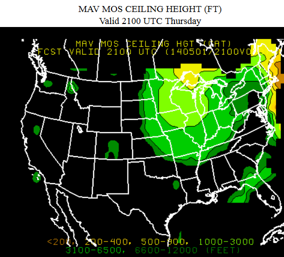
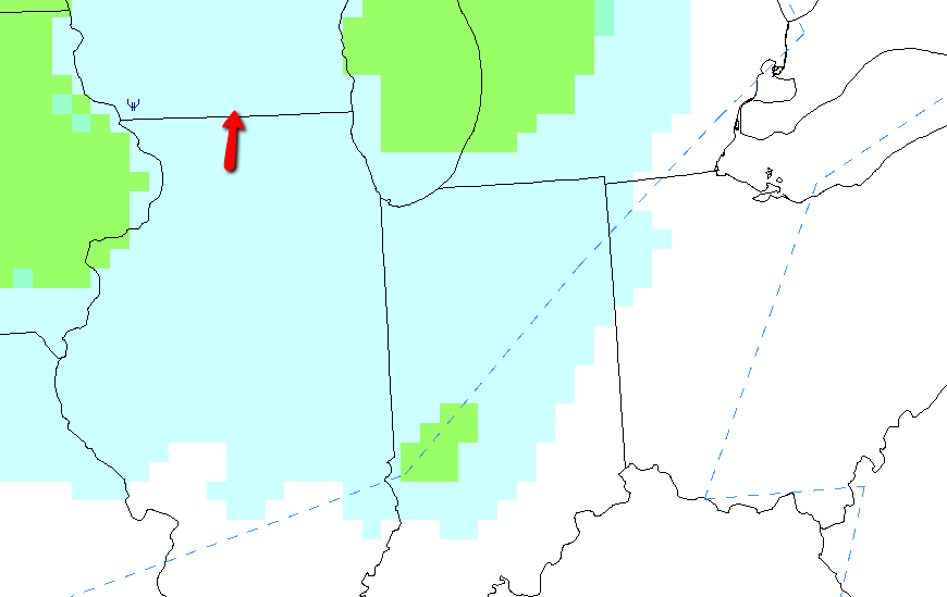
Supporting cast members...first, ceiling forecast:
2014-04-30_1549.png


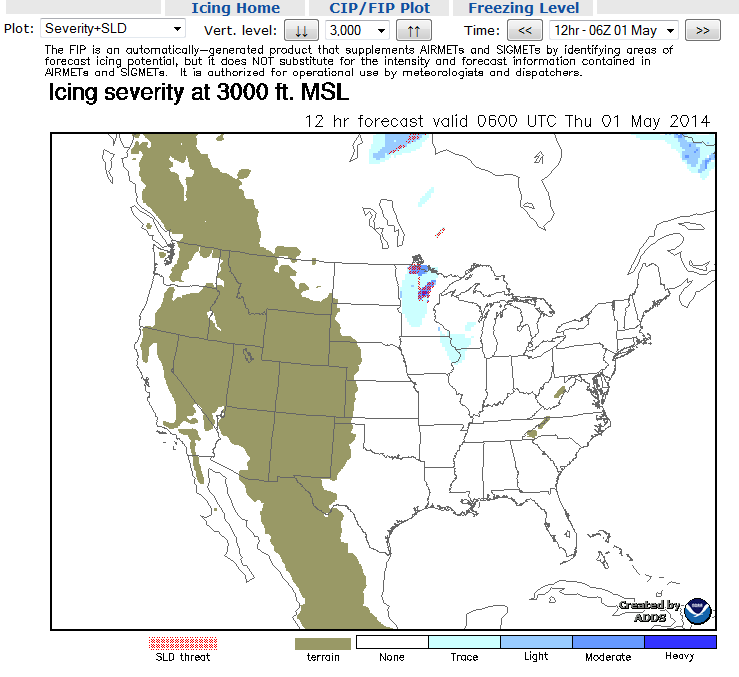
Icing forecast @ 3000 (neg @ 1000.. but 1000msl up there is only 500 AGL)
(from http://aviationweather.gov/icing/fip)
2014-04-30_1532.png


and at 5000:
2014-04-30_1540.png


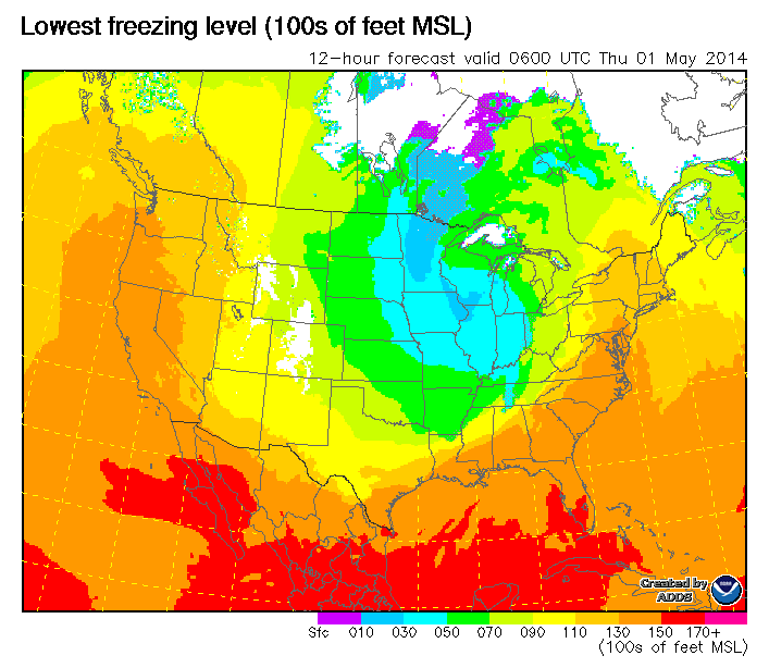
freezing level forecast:
2014-04-30_1541.png


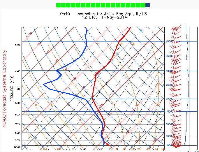
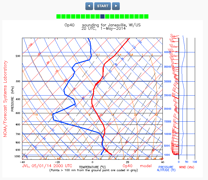
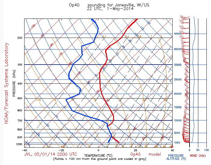
skew-t for roughly same timeframe:
(from avwxworkshops.com)
2014-04-30_1533.png
 
IR student here. I may be way off but I thought the rule for off airway planning was if your are in mountainous terrain to have at least 2000' AGL and non mountainous terrain at least 1000' AGL, both within 4 miles of your selected route. Please correct me if I am off base, like I said, I am only a student.

edit: 2000' and 1000' above the highest obstacle I believe it was. I'll have to check when I get home.
 
Last edited:
If ATC will give you that low, then sure, but don't count on it.
 
Why wouldn't they? I'm well outside of any Chicago airspace issues.
Many places don't have radar coverage that low. Around here it's 4,000' minimum and they'll still lose you in some areas down in Northern Arkansas even at that altitude.

It's kinda hard for ATC to provide adequate separation services when they can't see you on radar.
 
What are the tops? That CIP is good, but the Skew-Ts are better.
 
the TAFs - showing broken/ovc 3500-4500msl along the route.. VFR at 2500 is good for the route (I'm pretty familiar with it) 600-900 foot terrain.

Thoughts?

Icing forecast @ 3000
Scud run
 
What are the tops? That CIP is good, but the Skew-Ts are better.

CIP is clear at 12-13k. So I'm assuming tops around there. Descending thru 8k of clouds with a warming trend at the top (see skew-t below) seems dangerous.

CIP has no ice past 20z at 3000 or below.
4000 at 21z is this:
2014-05-01_0900.png


Latest skew-t @ destination for departure time:
2014-05-01_0848.png

And for arrival:
2014-05-01_0859.png
 
Not an expert, but that Skew-T looks pretty saturated up to at least 20,000 feet. Try PIREPs, but without clear evidence of low tops, I would stay VFR on a day like this.
 
I am not a skew T guru at all, but it looks to me like the split comes between 5-10K. Am I reading that wrong?
 
Matt, from the original one I posted, it does. The latest one shows both temp/dp on top of each other thru 8-9k..
There is a rule about assuming clouds clearing with a amount of temp/dewpoint spread but I can't recall it now.. need to go back to Scott's workshops and find out.
 
Just saw the new Skew-T -- yes, I agree (again, not an expert), a clear split somewhere round 8k or so. Still, that's 4-5 kft of clouds below freezing, with (from the earlier CIP images) significant risk of icing in them. I'd stay out of them.
 
Plus you're going around Chicago, which means your IFR routing is gonna blow. Might as well go VFR, and fly up the shoreline.
 
Your arrival one isn't showing up for me.

Tops look around 8k. Freezing level around 4k.

VFR would be my recommendation. If unable, stay home.
 
Yep - the idea is to be only in the clouds under 4000 feet. Appears freezing level will be 4000-5000 by then.

Pireps so far indicate mixed reviews. Will see once the day goes on.. Need to put some deice on that 310 and we have a deal, Matt!
 
Plus you're going around Chicago, which means your IFR routing is gonna blow. Might as well go VFR, and fly up the shoreline.
Yeah. If it really looks like 2500ovc as the minimum the whole way, that's not a bad plan. Done it before. Just have to have my head on a swivel running the shoreline on a compressed altitude day...

Your arrival one isn't showing up for me.

Tops look around 8k. Freezing level around 4k.

VFR would be my recommendation. If unable, stay home.

Here is it -http://screencast.com/t/9p6kNKjG9X
not much changed, just freezing level is inched up to just under 5000.

I'm hoping it'll be VFR-able. Or IFR out of Dayton and then cancel under somewhere Northern IL.

Or drive.
 
I'm hoping it'll be VFR-able. Or IFR out of Dayton and then cancel under somewhere Northern IL.

Or drive.
Looks like there's an Airmet Sierra out NW of Chicago that's forecast to continue through 21Z.

I'd drive.
 
I flew. Left around 5pm on Thursday and got home 7pm last night.

Conditions were fine at MGY when I departed. Scattered 5000 then broken 6000 and overcast a little above that.
I filed at 4000, knowing it would be just around the freezing level, but observations along the route were indicating I had a lower out to to VFR and no terrain issues. And many reports were showing I would be in and out of the clouds, not stuck in them all the time.

Here is the situation once I got leveled out:
IMG_0045.JPG


Here was the norm for the first hour or so. I was trued out at about 145kts (foreflight is in mph) and had groundspeed of 127-130kts for most of the westward trip.

OAT started out at 40f, then crept down to 35f passing Muncie.

>

I think this is Kokomo in the left third of this pic just under the clouds:
https://www.icloud.com/photostream/#A5GWZuqDGKR9uY;B92F8D47-279B-4978-A5AE-5968C83FA5CF


OAT is now down to 32f/0c... right at freezing. I was in and out of clouds and just got water on the windshield and wings. Nothing stuck. Lots of folks were at 6000 asking to come down. I thought about asking for a brief trip up just to see how icy it was, but with freezing temps at my desired altitude, I didn't want to end up having to go low to shed it.

Things were looking better along the route anyways, 6:30pm, 1.5hrs after departure:
https://www.icloud.com/photostream/#A5GWZuqDGKR9uY;6F1AA073-F849-456D-A7E9-7B3418375E2E

Then the fun begins... In and out of this for 45 minutes:
https://www.icloud.com/photostream/#A5GWZuqDGKR9uY;CCD94883-5951-40DF-9FBB-DDB4D03F3D61
 
Last edited:
Continuing thread... I think posting pics from icloud makes the forum unhappy..

The turn north to JVL:
https://www.icloud.com/photostream/#A5GWZuqDGKR9uY;17BFF685-6A3D-42DD-9201-D0F50FBF6FB9

This was about 2hrs after departure (time changed to CST), turning at everyone's fav intersection around Chicago, KELSI:
https://www.icloud.com/photostream/#A5GWZuqDGKR9uY;1D6E1D8E-58DB-4F3E-921A-A868A835CEFE

Everyone was nice on the way up thru, seems some folks earlier in the day had some icing issues.. but with ceilings opening up it was not bad at all. I never felt like I needed to go lower than 4000 or change my plan of action.

Here is turning onto the ILS 32 at JVL:
https://www.icloud.com/photostream/#A5GWZuqDGKR9uY;7720DCE4-028C-44B8-80A3-E1B7D4E46DDE

Landing was fun - 270@14 gusting to something higher. Always wind in WI... I have a video I'll post once it uploads.

Return trip yesterday helped payback for the crappy weather going up (211kts! but averaging 180-190):
https://www.icloud.com/photostream/#A5GWZuqDGKR9uY;7955776A-D0FE-451D-8ED5-D6A49E14CFDC


Thanks for the advice,
 
Last edited:
You got KELSI?

Color me shocked.
 
You probably wont get the routing you depict either. Do you believe you will be the only guy wanting to stay low?

I've never had a problem getting the altitude I need for icing reasons, and certainly never gotten a reroute for it.
 
I gotta revive this thread. Last Thursday I flew to KMPV for a job interview. My first destination was to be 6B0 (Middlebury, VT) for fuel, since fuel at MPV is sky high. I filed to KSDC for a pit stop along the way, then realized that I wouldn't need it, got cleared direct to 6B0 from just west of Buffalo. By then I was over a solid undercast at 7000 with bright clear sky above, and it stayed that way all the way across New York. Gradually the tops started coming up, and the OAT (as read on the EDM-700) went down from 10 to 7 to 5. After a temporary reroute due to the MOAs over the Adirondacks going hot for all of 30 minutes, I found myself skimming the tops until finally I was solid IMC. The OAT gauge read 3C. Within less than 5 minutes I saw clear ice forming very quickly on the windshield. Still 3 degrees on the OAT. So far nothing visible on the leading edges, but I knew it had to be forming somewhere, maybe on the prop or the tail, and it was forming FAST, so I immediately asked for higher and got 9000. The ice was gone within 30 seconds of exiting the clouds back into the bright sunshine.

So how the heck did this happen? Is my OAT gauge miscalibrated or the sensor mispositioned (unlikely, it usually seems to agree well with AWOS temp reports on the ground), or is adiabatic compression heating at the temperature probe a factor even at 125 kts?
 
Liquid water can be liquid water at temperatures below freezing. They call this "super cooled droplets". When it hits your airplane it freezes. So it is was water below freezing, it is now ice below freezing. Ice below freezing can exist in air above freezing.

It IS true that in order for water to be frozen it MUST be 0C or below (at any atmospheric pressure an airplane would encounter). If you don't believe me, look up "triple point graph" and/or take a class in thermodynamics. This is where the confusion comes from. "If it is ice, it must be below freezing" is true. Therefore we make the jump to the conclusion that "if the air is above freezing, it must not be ice" which is NOT true. (the air is above freezing, but the ice isn't).

Experiments have been done where they put a glass of water in a very cold freezer (that has been rigged so it doesn't vibrate whatsoever). Take it down very cold, say below -10C. It stays water. Now tap it, and instantly the water all freezes! It is sort of like surface tension. Just one of many curiosities of the water molecule.

Hope that helps.
 
Last edited:
My guess, the temperature indicator is incorrect. Mine always reads higher than what it really is.
 
Liquid water can be liquid water at temperatures below freezing. They call this "super cooled droplets". When it hits your airplane it freezes. So it is was water below freezing, it is now ice below freezing. Ice below freezing can exist in air above freezing.
Please explain how supercooled water comes to exist in a significantly above-freezing stratocumulus cloud with clear blue sky above.

Even assuming that is possible (and I'll defer to Scott D. or another meteorology expert on that), please explain how rapid ice accretion can occur in an above freezing environment on an airframe that is at ambient temperature (i.e., not cold soaked).

It IS true that in order for water to be frozen it MUST be 0C or below (at any atmospheric pressure an airplane would encounter). If you don't believe me, look up "triple point graph" and/or take a class in thermodynamics. This is where the confusion comes from. "If it is ice, it must be below freezing" is true. Therefore we make the jump to the conclusion that "if the air is above freezing, it must not be ice" which is NOT true. (the air is above freezing, but the ice isn't).
Speak for yourself. I don't think I've jumped to any such conclusion. However, if the water is below freezing in an above freezing environment, please explain how it remains below ambient temperature when diabatic processes are acting to bring the system into thermal equilibrium. This is a stratocumulus cloud, not a thunderstorm.

Experiments have been done where they put a glass of water in a very cold freezer (that has been rigged so it doesn't vibrate whatsoever). Take it down very cold, say below -10C. It stays water. Now tap it, and instantly the water all freezes! It is sort of like surface tension. Just one of many curiosities of the water molecule.
For some value of "sort of", I suppose.

Hope that helps.
Not really, and your attitude is kind of annoying. I had a more respectful reply up going into the thermodynamics but I erased it, since this kind of smug, condescending post doesn't deserve it.
 
My guess, the temperature indicator is incorrect. Mine always reads higher than what it really is.
Mine usually reads close to what the AWOS reports on the ground. I agree that it's likely an incorrect reading, the question is whether it's calibration error or that the sensor was sampling air that was above ambient temperature for some reason.
 
My guess, the temperature indicator is incorrect. Mine always reads higher than what it really is.
Okay, gotta chime in again... on my latest flight a couple of days ago, I paid close attention to the OAT vs. the AWOS and this time, I noticed a 3 degree difference. The OAT read higher. Could be a lot of things, including a temperature difference from one side of the field to the other. OTOH maybe there is a calibration issue here. Next time I'll assume it's actually freezing or below if it reads less than 5C.
 
My OAT is digital on the G1000 and reacts instantly to changes. I have noticed that crossing a system I can be in say +5 conditions and a column of air can hit me and take it to 0 or below in a split second. I then pick up ice and in another few seconds I can be out of the column and back to positive temps. This usually happens in the spring, I guess because of more vertical movement of air associated with spring storms. This is really easy to miss if your OAT is slow to react.

I have observed this many times and it's to the point that if I am in rain near freezing, I will expect ice when I feel a downdraft hit the airframe.

Just another thought.
 
Good point, but not the case here. As I wrote above, this was a stratocumulus cloud with clear blue sky above. A fairly stable environment, and at least by the gauge, pretty homogeneous as regards temperature.

I'm pretty sure the explanation in my case is instrument error.
 
Okay, gotta chime in again... on my latest flight a couple of days ago, I paid close attention to the OAT vs. the AWOS and this time, I noticed a 3 degree difference. The OAT read higher. Could be a lot of things, including a temperature difference from one side of the field to the other. OTOH maybe there is a calibration issue here. Next time I'll assume it's actually freezing or below if it reads less than 5C.

I'd be curious what the probe reads when surrounded by a bag of ice water (50% ice, 50% water) after waiting for temps to stabilize--poor man's probe calibration. The temperature of that bag should be right around 0dC (melting point of the ice in the bag).
 
Back
Top