Lawreston
En-Route
Road to Georgetown, Reid State Park, and Five Islands.
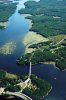
Kennebec River at right(out of picture); Sasanoa River pictured here. “Hell’s Gate” may not be pictured here, but it may be that narrow channel at upper left. “Word” is that, when taking a boat through it, better be at ½ to ¾ tide because at tide change it’s wild and dangerous(been there-done that). The large tour boats out of Boothbay Harbor come up through there, en route to “show” Bath Iron Works to the passengers. ½ of the Dairy Queen parking lot can be seen at lower left corner. At this point, Wiscasset Airport was minutes away(September 12, 2012). You Maine and NH flyers will instantly recognize the scene(if you've headed to or out of Wiscasset). Photo from 09/12/2012.
HR