Course reversal - how would you turn around?

What about the positioning of the angled portion of the PT on the plan view? Does that mean that you have to fly the turning portion of the PT outside the 057 degree radial, or is that positioning just coincidence?

(I think I know the answer because of another thread in the past six months, but I want to see what others have to say.)

I'm putting my money on coincidence since the profile view says remain within 10nm of the LOM.
 
The NoPT there seems to be superfluous. The only two ways you could get on that intermediate segment from CURLI to STOGL other than via the PT would be via the PVD 052, which is already marked NoPT, or via vectors to final, which by definition is NoPT.

I agree that the NoPT notation in this case seems to be superfluous. The Jepp version also has it.

Since there's no "GPS" in the approach name, the controller is not authorized to let GPS-equipped aircraft proceed direct to CURLI for a straight-in approach.

Interesting. Direct CUTMA to join the rwy 36 localizer at OXC is a familiar clearance issued by NY Approach anytime we approach from the east.

What about the positioning of the angled portion of the PT on the plan view? Does that mean that you have to fly the turning portion of the PT outside the 057 degree radial, or is that positioning just coincidence?

(I think I know the answer because of another thread in the past six months, but I want to see what others have to say.)

I would say coincidence due to the plan view layout on this particular procedure. See the Jepp version below:

attachment.php
 

Attachments

  • loc35owd copy.jpg
    loc35owd copy.jpg
    228.7 KB · Views: 79
Last edited:
The only two ways you could get on that intermediate segment from CURLI to STOGL other than via the PT would be via the PVD 052, which is already marked NoPT, or via vectors to final, which by definition is NoPT.
Not enough information to make that statement. I would need a surrounding area chart to see where I might be coming direct from the east to intercept the localizer at CURLI.
Since there's no "GPS" in the approach name, the controller is not authorized to let GPS-equipped aircraft proceed direct to CURLI for a straight-in approach.
?? In this case, the GPS (or whatever device you are using) would not be a part of the approach, but a means of enroute arriving at a point on the approach which is straight-in.
 
I'm not sure what you're referring to by the 057 radial, but the bar for the PT is simply saying that that direction (W of the final course) is the protected side. It's recommending an initial turn to 215 degrees outbound, then 035 back inbound, but you can do what ever type of course reversal you want so long as you're within 10nm of OW and on the protected side.

That I see, the 057* radial is just there to identify the transition route from PVD and to use as a cross radial to identify CURLE without DME.

I see I wasn't able to fool anyone with my question. On a Red Board thread a while back, we eventually found out that the way to tell what fix you are supposed to remain within 10 nm of is to look at the profile view, and see what fix the descending bold line starts at.
 
What about the positioning of the angled portion of the PT on the plan view? Does that mean that you have to fly the turning portion of the PT outside the 057 degree radial, or is that positioning just coincidence?
Coincidence. You can fly the reversal as close as you want to the base fix (STOGE), and you must stay within the specified distance on the profile view (10nm) while you do it.
 
Interesting. Direct CUTMA to join the rwy 36 localizer at OXC is a familiar clearance issued by NY Approach anytime we approach from the east.
As I said, there are controllers who do it, but it isn't currently authorized in 7110.65, and there's nothing in any pilot publication saying it's OK for us to do.
 
Not enough information to make that statement. I would need a surrounding area chart to see where I might be coming direct from the east to intercept the localizer at CURLI.
Doesn't matter what's on the Area Chart. There is no authorization to begin approaches by going direct to the IF other than for Advanced RNAV aircraft on GPS or RNAV(GPS) approaches.
 
As I said, there are controllers who do it, but it isn't currently authorized in 7110.65, and there's nothing in any pilot publication saying it's OK for us to do.

Can it not be issued in lieu of a radar vector to join outside of the fix? IOW, what's the difference between "Five miles south of CURLE, fly heading 310, maintain 2,000 until established, cleared Localizer rwy 35, Norwood" and "Five miles south of CURLE, proceed direct CURLE, maintain 2,000 until established, cleared localizer..."? In either case you're being given a way to join the course outside of the FAF. It's just a matter of how far out and what level of automation you use to get there.
 
Can it not be issued in lieu of a radar vector to join outside of the fix? IOW, what's the difference between "Five miles south of CURLE, fly heading 310, maintain 2,000 until established, cleared Localizer rwy 35, Norwood" and "Five miles south of CURLE, proceed direct CURLE, maintain 2,000 until established, cleared localizer..."?
Read 7110.65 -- it's just not authorized. Part of the potential problem is the chance of departing the protected airspace due to turn radius, or being unable to get stabilized on the intermediate segment before reaching the FAF, or being unable to reach the FAF altitude from the last assigned altitude after stabilizing on the intermediate segment without using an excessive descent gradient (more than 318 ft/nm recommended, 400 ft/nm max).

These issues are resolved for VTF with the limits imposed in 7110.65 (max 30 degrees intercept, intercept outside final approach gate, etc). They are resolved for the GPS situation with the limits on that clearance (max 90 degree turn, etc) plus turnpoint anticipation. The FAA is, I understand, working on ways to allow direct-IF clearances to join approaches at the IF, but they need to evaluate how to write the limits so there's no problem with staying within the protected airspace, getting established before the FAF, and no descent gradient issues.
 
b) Generally no, but there are points in mainland Mexico (eg: Puerto Vallarta, Mazatlan, Manzanillo) from whence there could be northbound arrivals at the VOR.

Enjoyed the jam session!

Re b), above:
The heading from Puerto Vallarta to Cabo (just about the most southerly route from the mainland) is 300°, and in the first chart posted this thread, route UL-312 seems to have made provisions for 'southerly' arrivals....so I doubt this scenario could really happen. In fact I bet you'd get routed along the shoreline in many cases anyway.
 
Here is some info from Jeppesen regarding the IAF designation at SJD on the VOR DME-2 RWY 16 approach at MMSD:

As designated by the absence of a design criteria label in the lower left-hand corner of the approach chart, Mexico does not wholly subscribe to either TERPS or PANS-OPS. AIP AD-2 MMSD VOR DME 2 Rwy 16 designates SJD VOR as an IAF. Bottom line, we are not exactly certain why they designate SJD as an IAF. I have a couple of ideas:


  1. They build a TMA chart (the Jeppesen equivalent 10-1B ), which runs enroute airways to a central VOR (usually located on the field). These enroute airways are also used in the terminal environment, as designated on the 10-1B. This VOR can be labeled as an IAF because these airways can be used as the initial approach segment back to the DME arc. The reason that Jeppesen does not extend the airways to the VOR on the approach chart is because the Mexico AIP AD chart does not.
  2. They designed the procedure with the intent that RADAR would be available (even though it’s not listed as an equipment requirement note) and vectoring from the IAF at SJD would be available.
This procedure is older (the AD chart is dated 2004) – and I’ve noticed that the newer “VOR DME 2” procedures do not designate the aerodrome VOR as an IAF. This may be a situation where the AIS Mexico updated their specifications.

Sorry I could not be more definitive.
 
Ask for the -1 or get recleared for the arc. Yes, they do notice down there. Cabo Tower doesn't have radar, but approach does. They will see what you're doing. They're very accommodating as well. Folks are too afraid to ask for some reason. Remember that in Mexico and most of South America that you are responsible for terrain avoidance, not center or approach.
 
Doesn't matter what's on the Area Chart. There is no authorization to begin approaches by going direct to the IF other than for Advanced RNAV aircraft on GPS or RNAV(GPS) approaches.
Boy, am I behind the times. Don't know much about RNAV and GPS stuff, and I guess that's a controller's manual that you're referring to, which we pilots don't need to know. Yes, I agree it is good information, but for this discussion, it shouldn't be a necessary reference.

Anyway, to get back to my understanding, are you saying that, if I could navigate on a vor radial to an IF that is NoPT to the FAF, that I couldn't do it?
 
Anyway, to get back to my understanding, are you saying that, if I could navigate on a vor radial to an IF that is NoPT to the FAF, that I couldn't do it?

That's they way I interpreted Ron's statement. Which I think makes sense. On the plate I posted there are only 2 ways to get to the IF: 1) Using the VOR as the IAF, which would be the full approach; 2) Using the compass locator to line up on the localizer some distance outside of the IF, which wouldn't really be heading direct to the IF anyway. You'd be intercepting a bearing from the compass locator, and then following the localizer to the IF.

I think for VOR navigation, you usually can't really navigate to the IF without going through an IAF somewhere. When you have RNAV/GPS then you run into the problem.
 
Boy, am I behind the times. Don't know much about RNAV and GPS stuff, and I guess that's a controller's manual that you're referring to, which we pilots don't need to know. Yes, I agree it is good information, but for this discussion, it shouldn't be a necessary reference.

Anyway, to get back to my understanding, are you saying that, if I could navigate on a vor radial to an IF that is NoPT to the FAF, that I couldn't do it?

Everything the pilot needs to know should be in the AIM. That said, 7110.65T is the controller equivalent to the AIM and provides some useful insights into what the controller is doing and why. I recommend that every instrument pilot download it and browse thru it to get an idea of what the other side is told to do. At least you can use it as a resource when you have a question. The document and some recent updates can be downloaded from http://www.faa.gov/air_traffic/publications/ in the orders section.
 
Can it not be issued in lieu of a radar vector to join outside of the fix? IOW, what's the difference between "Five miles south of CURLE, fly heading 310, maintain 2,000 until established, cleared Localizer rwy 35, Norwood" and "Five miles south of CURLE, proceed direct CURLE, maintain 2,000 until established, cleared localizer..."? In either case you're being given a way to join the course outside of the FAF. It's just a matter of how far out and what level of automation you use to get there.

The second clearance requires an RNAV capability to "proceed direct CURLE" and is not a vector to final. If the clearance had been "Five miles south of CURLE, fly heading 310, maintain 2,500 until established on the localizer, cross CURLE at 2200, cleared Localizer rwy 35, Norwood", then it would have been a vector to the localizer and could be issued by the controller. In the AIM 5-4-7 Instrument Approach Procedures the only exception to requiring starting the approach at an IAF or feeder route is if the aircraft is being radar vectored to the final approach course. There is another exception for appropriate RNAV equipped aircraft to join the approach at an IF on a RNAV (GPS) approach.

e. Except when being radar vectored to the final approach course, when cleared for a specifically prescribed IAP; i.e., “cleared ILS runway one niner approach” or when “cleared approach” i.e., execution of any procedure prescribed for the airport, pilots shall execute the entire procedure commencing at an IAF or an associated feeder route as described on the IAP chart unless an appropriate new or revised ATC
clearance is received, or the IFR flight plan is canceled.​

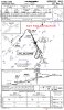
The following clearance is in a gray area "Five miles south of CURLE, proceed direct CURLE, maintain 2,200 until established, cleared straight-in Localizer RWY 35 Norwood" It would be a random course to CURLE which is both a part of a feeder route and an IF. The IAF would be STOGE (OW) and require the PT, but with the addition of the straight-in portion of the approach clearance, the PT would not be flown. AIM 5-4-7 paragraph b. states:

b. When operating on an unpublished route or while being radar vectored, the pilot, when an approach clearance is received, shall, in addition to complying with the minimum altitudes for IFR operations (14 CFR Section 91.177), maintain the last assigned altitude unless a different altitude is
assigned by ATC, or until the aircraft is established on a segment of a published route or IAP. After the aircraft is so established, published altitudes apply to descent within each succeeding route or approach segment unless a different altitude is assigned by ATC. Notwithstanding this pilot responsibility, for aircraft operating on unpublished routes or while being radar vectored, ATC will, except when conducting a radar approach, issue an IFR approach clearance only after the aircraft is established on a segment of a published route or IAP, or assign an altitude to maintain until the aircraft is established on a segment of a published route or instrument approach procedure. For this purpose, the procedure turn of a published IAP shall not be considered a segment of that IAP until the aircraft reaches the initial fix or navigation facility upon which the procedure turn is predicated.​
 
Last edited:
Boy, am I behind the times. Don't know much about RNAV and GPS stuff, and I guess that's a controller's manual that you're referring to, which we pilots don't need to know. Yes, I agree it is good information, but for this discussion, it shouldn't be a necessary reference.
Point taken. Go look in the AIM 5-4-6, 5-4-7, and 5-4-9. They don't give you the detail of what's in the ATC Handbook, but you get some of the idea of it. My point is that if the controller follows the book, you just won't get a direct-IF clearance on an ILS/LOC approach. The problem is the maverick controllers who do it anyway with a pilot who isn't familiar with all the restrictions in the controller's book. That's a good way to get a pilot killed, since it's entirely possible than an unauthorized direct-IF clearance could result in you departing the obstacle-protected airspace.

Anyway, to get back to my understanding, are you saying that, if I could navigate on a vor radial to an IF that is NoPT to the FAF, that I couldn't do it?
Not if that VOR radial is shown on the approach chart a defined route segment for that approach (course, distance, and altitude shown). However, in that case, the VOR should be marked as an IAF and "NoPT" shown on that segment. If not, then no, that's not an authorized procedure.

Take for example the ILS 32 into KSBY. You'll see the 021 radial from Snow Hill which defines COLBE intersection. However, it doesn't have a course, distance, and altitude as the 048 radial leading to FRYER does. That means the 021 radial is not a "published segment" of that SIAP, so if you fly the 021 to COLBE, when you get there, COLBE is an IAF and you must turn right and complete the HPILPT before proceeding inbound. OTOH, the 048 radial from SWL (which is marked as an IAF) is a published segment for that approach, and leads to FRYER as an IF. Follow that route, and COLBE is only an FAF when you get there, and you can continue straight in from that point (although I really think that segment from SWL-FRYER should be marked NoPT to avoid confusion).
 
Last edited:
Not if that VOR radial is shown on the approach chart a defined route segment for that approach (course, distance, and altitude shown). However, in that case, the VOR should be marked as an IAF and "NoPT" shown on that segment. If not, then no, that's not an authorized procedure.
The reason I originally said I would need to see the surrounding area
was to look for other vors in the area that i could be navigating off of.

For instance, say there was a vor 25 miles east of CURLE that I could use the 270 radial to get to CURLE, then proceed inbound on the LOC with NoPT.
 
The reason I originally said I would need to see the surrounding area
was to look for other vors in the area that i could be navigating off of.

For instance, say there was a vor 25 miles east of CURLE that I could use the 270 radial to get to CURLE, then proceed inbound on the LOC with NoPT.

CURLI does not appear to be on the enroute chart, so the only published route to it appears to be the transition from PVD.

http://skyvector.com/?ll=42.190527778,-71.172944444&chart=433&zoom=3
 
There's a STAR for OWD - WOONS1. That STAR is not on a radial from PVD, it's off of the WOONS fix. As a practical matter, if you're arriving at OWD from the west or south, you'll get routed over WOONS (BTDT several times).

WOONS is not an IAF for the approach, but you will get a vector from WOONS to intercept the final approach course at something below 3000', which is the "expect" altitude at WOONS. IIRC, I was cleared to descend to either 2000 or 1500 after leaving WOONS to intercept. STOGE is both an IAF and FAF on the approach.
 
CURLI does not appear to be on the enroute chart, so the only published route to it appears to be the transition from PVD.
I kinda thought that was the thinking here. I'm not talking about a "published route".

There are three NDBs within 25 nm of CURLI. Why can't I fly direct from any NDB to CURLI, then straight-in on the LOC?
 
I kinda thought that was the thinking here. I'm not talking about a "published route".

There are three NDBs within 25 nm of CURLI. Why can't I fly direct from any NDB to CURLI, then straight-in on the LOC?

What would the minimum altitude be for that route?

It's true that ATC can approve random routes when you are in radar coverage, in which case you would fly whatever altitude they told you to, but some people say that ATC can't clear you to start an approach at an intermediate fix (IF) if it is not an RNAV or GPS approach.

Of course, if the radar is operational, you're going to get vectors to final anyway, so it's moot. If the radar is out of service, then you would have to use a published route.

Richard Palm
 
Last edited:
I ran into this one a couple times last week looking at the VOR DME-2 RWY 16 at MMSD (San Jose Del Cabo), which I attached below. We came in from the north so the following scenario didn't have any effect on us, but it's still good conversation academically.

For arrivals from the south, the SJD VOR on the field is a published IAF, however there is no transition route to the arc or procedure turn (or HILO) listed. So how would you get turn around for this approach? (My vote was split-s, but that might spill the coffee).

On a related note, it took us entirely too long to figure out the initial altitude to fly to in the event of a missed approach.

Hey Matt!

Sorry i didn't read any of the replies, but this approach looks like one of those where the DME ARC is published in place of a PT.... IOW, it is one of the items on the list of "When a PT is not authorized"... one of those is - the absence of a PT barb. It looks like the only options are RVs, the Feeder route, or fly the ARC. Similar to Houston's ILS's.

The missed says climb to minimum holding altitude - the race track says 5,000 :D
 
Hey Matt!

Sorry i didn't read any of the replies, but this approach looks like one of those where the DME ARC is published in place of a PT.... IOW, it is one of the items on the list of "When a PT is not authorized"... one of those is - the absence of a PT barb. It looks like the only options are RVs, the Feeder route, or fly the ARC. Similar to Houston's ILS's.
The difference is that there is an initial approach fix on this approach that is essentially unusable. Doubt you'll find an approach like that at Houston or anywhere else in the United States.
 
What would the minimum altitude be for that route?
MSA - 1900 for the East thru South quadrant.
It's true that ATC can approve random routes when you are in radar coverage, in which case you would fly whatever altitude they told you to, but some people say that ATC can't clear you to start an approach at an intermediate fix (IF) if it is not an RNAV or GPS approach.

Of course, if the radar is operational, you're going to get vectors to final anyway, so it's moot. If the radar is out of service, then you would have to use a published route.
So this is what I need to find in the AIM - can you (anybody) reference it?
 
Last edited:
The difference is that there is an initial approach fix on this approach that is essentially unusable. Doubt you'll find an approach like that at Houston or anywhere else in the United States.

I bet you do find several approaches like this in the United States! The obvious difference, which you failed to see/note in your reply is that they will be ICAO compliant in the US. The IAF in this approach is usable and the procedure designer only failed to ensure compliance. I haven't read any of the replies but I'd imagine that over several pages of responses some must have already hit upon that. Still, what I said holds true. No PT barb, no HILTP, no published teardrop PT, radar vectors..... no pt.
 
Last edited:
I kinda thought that was the thinking here. I'm not talking about a "published route".

There are three NDBs within 25 nm of CURLI. Why can't I fly direct from any NDB to CURLI, then straight-in on the LOC?
Because the FAA has not confirmed that the turn radius from those directions will keep you within obstruction clearance space and tolerances for becoming established on the localizer. As I said earlier, I've heard the FAA is examining ways to increase the number of options available for direct-IF routings, but given the number of variables involved, there's a lot for them to process and check against the TERPS.
 
It's true that ATC can approve random routes when you are in radar coverage, in which case you would fly whatever altitude they told you to, but some people say that ATC can't clear you to start an approach at an intermediate fix (IF) if it is not an RNAV or GPS approach.
The people who say that are the FAA people who wrote FAA Order 7110.65. Controllers are simply not authorized to issue such a clearance. Of course, you won't find anything specifically saying that, but you won't find anything authorizing it, and that's the key when it comes to issuing approach clearances.
 
MSA - 1900 for the East thru South quadrant.
MSA's are for emergency use. They are not considered published altitudes for random route segments like MVA's on the controller's scope (which don't appear on any pilot charts). See AIM 5-4-5e for more.

Palmpilot said:
Of course, if the radar is operational, you're going to get vectors to final anyway, so it's moot. If the radar is out of service, then you would have to use a published route.
So this is what I need to find in the AIM - can you (anybody) reference it?
See AIM 5-4-6:
e. Except when being radar vectored to the final approach course, when cleared for a specifically prescribed IAP; i.e., “cleared ILS runway one niner approach” or when “cleared approach” i.e., execution of any procedure prescribed for the airport, pilots shall execute the entire procedure commencing at an IAF or an associated feeder route as described on the IAP chart unless an appropriate new or revised ATC clearance is received, or the IFR flight plan is canceled.
...and the only way to join inside the IAF controllers are currently authorized by FAA Order 7110.65 to issue other than VTF is the RNAV(GPS)/GPS direct-IF clearance discussed for pilots in AIM 5-4-7i.
 
I bet you do find several approaches like this in the United States! The obvious difference, which you failed to see/note in your reply is that they will be ICAO compliant in the US. The IAF in this approach is usable and the procedure designer only failed to ensure compliance. I haven't read any of the replies but I'd imagine that over several pages of responses some must have already hit upon that. Still, what I said holds true. No PT barb, no HILTP, no published teardrop PT, radar vectors..... no pt.
As Ron points out. If there is an IAF that is unusable in the United States it is in error.

Please tell me how that IAF can be of use?
 
So this is what I need to find in the AIM - can you (anybody) reference it?

In addition to what Ron said, if I recall correctly, Roncachamp, who is a controller, has posted that radar contact is required in order for ATC to clear you on a random (unpublished) route. I believe he quoted a passage from the controllers' manual on this, but I don't have the citation. If there is similar language in the AIM, I don't know where it is.
 
In addition to what Ron said, if I recall correctly, Roncachamp, who is a controller, has posted that radar contact is required in order for ATC to clear you on a random (unpublished) route. I believe he quoted a passage from the controllers' manual on this, but I don't have the citation. If there is similar language in the AIM, I don't know where it is.

Richard,

Finding stuff in the AIM is too easy if you have a PDF version. If you haven't already done so, download the PDF version of the full AIM from the FAA site, the file dated 2/11/10. It won't have change 1, 2, and 3, but will have the basics for the full document. I also download the changes and search them if I don't find what I need in the base document. Search the document on the word "random". You will find the reference in the AIM after you skip over a few occurrences.
 
As Ron points out. If there is an IAF that is unusable in the United States it is in error.
Actually, that is what I pointed out


Please tell me how that IAF can be of use?

On the Pegusus FMS trainer, by correcting the discontinuity the approach is seemlessly tied into the approach starting at the IAF. It isn't useful in many conventional capacities, including some RNAV units, how ever the fact that the IAF may be used and ties into the FAC through an FMC means the IAF is I. Fact usable by a navigational method. Wether or not it can be used by the most amount of aircraft is not important with some foreign approaches. That airport is not ICAO compliant, so it need not follow all ICAO or PAN OPS requirements. The question is, is the IAF useable. The answer is yes, but being no. ICAO compliant it does not matter who can fly that approach. You can only accept it if you can comply with the requirements of the approach and that is the bottom line.
 
On the Pegusus FMS trainer, by correcting the discontinuity the approach is seemlessly tied into the approach starting at the IAF. It isn't useful in many conventional capacities, including some RNAV units, how ever the fact that the IAF may be used and ties into the FAC through an FMC means the IAF is I. Fact usable by a navigational method. Wether or not it can be used by the most amount of aircraft is not important with some foreign approaches. That airport is not ICAO compliant, so it need not follow all ICAO or PAN OPS requirements. The question is, is the IAF useable. The answer is yes, but being no. ICAO compliant it does not matter who can fly that approach. You can only accept it if you can comply with the requirements of the approach and that is the bottom line.
That paragraph makes absolutely no sense.
bob_albertson said:
I bet you do find several approaches like this in the United States!
Where?
 
Last edited:
Side question: For you folks who post the nicely re-sized Jepp charts here on the forum -- where are you getting those from? Does one of the Jepp products allow you to export them nicely like that?
 
Side question: For you folks who post the nicely re-sized Jepp charts here on the forum -- where are you getting those from? Does one of the Jepp products allow you to export them nicely like that?

I just did a screen capture and then saved it in Paint, which sizes it just about right.
 
Side question: For you folks who post the nicely re-sized Jepp charts here on the forum -- where are you getting those from? Does one of the Jepp products allow you to export them nicely like that?

Jepp view converts the charts to PDF
 
Back
Top