No, that procedure has been around for years.
yep it has ...FAF altitude must check
No, that procedure has been around for years.
yep it has ...FAF altitude must check
I'm curious how you do this with a NOAA plate. I know Jepps have the recommended altitudes on them, but how about something like this ILS into TEB?Every plate I can recall always designates two definable locations along the glide slope before you get close in. If I'm on altitude and needle at those 2 points, my confidence is high enough.

All I'm saying maybe the training should allow or emphasize this cross check and verification, don't you think? Today it's not.
Old school instrument training emphasized cross check, verification and situational awareness much more than todays GPS world.
There may not be a way to track specific altitudes, but you can check the descent rate. If you are flying a typical piston single and having to maintain a 1000+FPM descent to maintain GS, then something might not be quite right.The intercept altitude is the acid test. Wrong place, wrong time - no go. Intercept the GS at the right place and at the right altitude - go. There is no way to track the altitude(s) going down the GS, unless you want to mathematically calculate them on the way down.
There may not be a way to track specific altitudes, but you can check the descent rate. If you are flying a typical piston single and having to maintain a 1000+FPM descent to maintain GS, then something might not be quite right.
If you watched the needle come down to meet you at the intercept, that should really be sufficient, if you get the next point as well, the chances of you having a problem are extremely small.
Flew an ILS yesterday for quarterly training. While I have SVT I still did a 3 mile check on the radar altimeter to make sure altitudes matched up. Use everything at your disposal.
Every plate I can recall always designates two definable locations along the glide slope before you get close in. If I'm on altitude and needle at those 2 points, my confidence is high enough.
Unless you have RA altitudes on the plate, just what are you checking?
Actually for me it's company SOP.
Do you guys just have to check the glide slope crossing altitude, or really the whole way down? If so, are you guys just using the RNAV distance to the End of Runway point?
Don't know who R&W flies for but my airline requires just the GS crossing altitude. I think that's pretty standard.
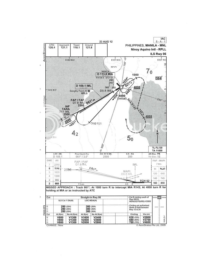
R&W, I am just curious about the missed approach at Manila. It assumes that you will reach the 145 radial before you have climbed to 4000', but what would you do if it turned out the other way, you got up to 4000' before the 145 radial. Would you then just slip the radial altogether and proceed directly to the hold over the airfield?
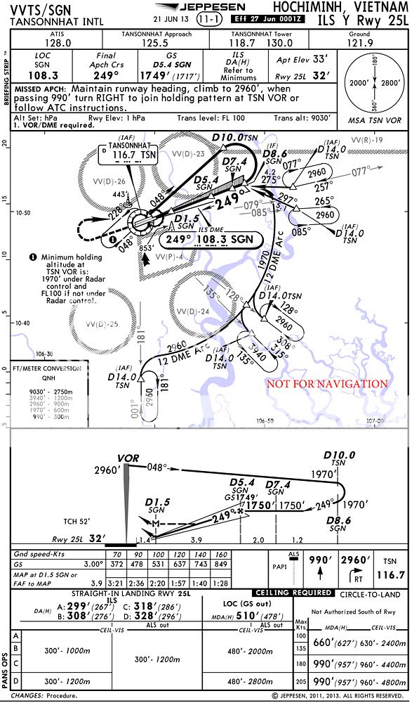
Thanks. And how do you use the table of altitudes vs DME that you mentioned? Is it your standard procedure to check altitude at one mile intervals using this table, while descending the glide slope? If so, how large must the discrepancy be, to cause you to go missed?
Thanks. And how do you use the table of altitudes vs DME that you mentioned? Is it your standard procedure to check altitude at one mile intervals using this table, while descending the glide slope? If so, how large must the discrepancy be, to cause you to go missed?
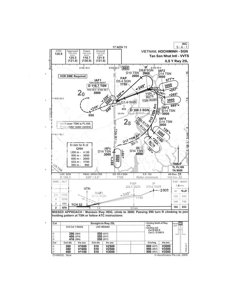
This is the chart most of us would be using:
Define "most". Out side the US operators use various charts, NavTech, Lido, Aerstratus, etc.
To me personally, I like Jepps, but there are many more in use.
Besides checking my MSL altimeter with the GS interception altitude, I give myself a halfway point to make sure my descent rate coincides with the ILS. For a 3 degree glidpath, that's 318 FPNM. Take my altitude at GS interception and subtract 318 for each mile. The RA is a back up but ONLY in flat terrain. If it's not flat then those altitudes in final aren't going to mesh with the MSL altimeter.
I also glance at the RA at DH to see if it matches HAT. Once again, ONLY accurate in flat terrain and only as a backup. Altimeter is primary. Having the "low bug" set to HAT will give a good wake up as well if you get an erroneous glidepath that's trying to descend you significantly below the norm.
