Cleared direct, but without safe obstacle clearance?

From my experience.

In the USA:

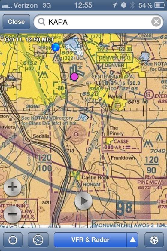
I've mistakenly filled low. I use FltPlan.com and it defaults to a set altitude based solely on length of flight. So if you file from DEN to ASE you could get a default alt that is lower than the dirt enroute. Once I neglected to look at the chart and used the default alt. There was a mountain range in between the departure and destination airport and then default altitude that I unwisely filed was below dirt. ATC saved me when I picked up my clearance and the cruise altitude was raised and there was no issue.

OUTSIDE the USA:

Never happened to me but I have heard stories of foreign ATC's giving the Captain whatever altitude he requests...even if that altitude flies them straight into a mountain. Their attitude is, "hey, he's the Captain. Who am I to second guess his authority?".
 
Beat me to it. Only time I would assign an altitude to a VFR on approach is when they request a radar approach. That way their altitude coincides with 5-9-1 b. & c. Still no requirement to do that of course.

We get 'em all the time here if flying practice IFR approaches.

It's to cap us below the Bravo, which most of our approaches start in.

"Maintain 8000, cleared for the ILS 35R at Centennial, maintain VFR."

They don't want you to fly it at the published 9000 for the procedure turn.

8uba2y9a.jpg
 
We get 'em all the time here if flying practice IFR approaches.

It's to cap us below the Bravo, which most of our approaches start in.

"Maintain 8000, cleared for the ILS 35R at Centennial, maintain VFR."

They don't want you to fly it at the published 9000 for the procedure turn.

8uba2y9a.jpg

Sure that's an air space thing in a Bravo. We get altitude restrictions in a B as well for separation from other aircraft. I referring to vectors below MVA without any altitude assigned. Yesterday I did a practice ASR at CHA. The controller never assigned an altitude. I would have preferred one so I knew what altitude to start my decent at on final. Not a big deal, but like I said, when I worked approach I always assigned an altitude to a VFR conducting a radar approach. That way I know their altitude will be IAW 5-9-1 b. & c. In the 7110.65.
 
Last edited:
Sure that's an air space thing in a Bravo. We get altitude restrictions in a B as well for separation from other aircraft. I referring to vectors below MVA without any altitude assigned. Yesterday I did a practice ASR at CHA. The controller never assigned an altitude. I would have preferred one so I knew what altitude to start my decent at on final. Not a big deal, but like I said, when I worked approach I always assigned an altitude to a VFR conducting a radar approach. That way I know their altitude will be IAW 5-9-1 b. & c. In the 7110.65.

You can request the recommended altitudes.
 
You can request the recommended altitudes.

Oh yeah I got recommended altitudes on final. I'm talking about the initial MVA to set me up for the approach. Basically I had to guess what altitude to start off at the 5 mile descent point. Now I know from experience that if I maintain 1,500 ft AGL until 5 miles, that'll set me up with roughly a 3 degree glide slope. Obviously for an ASR approach there's no glide slope but I picked an altitude that would give me about a 3 degree angle so I wouldn't have to dive too steep. The CHA controller told me for IFR inbounds they vector them at 2,700 ft (about 2000 AGL) until starting the descent at 5 miles. Seems pretty darn high to me.
 
Errm... even I know about OROCAs. I'm pretty sure Joe knows about them, too. ;)

The MVAs though, I don't believe are in publications available to the average, non-ATC pilot. I thought that was going to be your point... ?? :confused:

You are correct. Only ATC knows the MVA for any given area.
 
aterpster; I am puzzled on what the ATO guru might have meant by the above quote about the AIM language? I was looking at:

AIM 5-5-2 Air Traffic Clearance

b. Controller.
1. Issues appropriate clearances for the operation to be conducted, or being conducted, in accordance with established criteria.
2. Assigns altitudes in IFR clearances that are at or above the minimum IFR altitudes in controlled airspace.


and wondering if this is what he was referring to, though I have no idea why.


Should you get any further info, please post


thanks, Stan

Follow-up reply from ATO guru:

"Oops!!! The language is in the Instrument Procedures Handbook.

My bad!!"

It happens to all of us....well, most of us.:yes:
 
aterpster,
So he meant the IPH language is wrong, and he had no comment on the AIM?

that correct?
 
One can have an awareness of the terrain around them and how high they need to be without SVT. It's quite simple really.

No it's not, not in the mountains especially, scares the crap out of me anyway.
 
No it's not, not in the mountains especially, scares the crap out of me anyway.
Much less scary than the ocean. I don't have to worry about **** like this while in IMC:
Image-captures-whale-as-it-leaps-from-water-smashes-boat.jpg
 
It's a big ocean, I'm not worried at all about being attacked by Photoshop images....
 
Big fish, little disturbance to the water. Hmmmm...

The worst part of that image is that when you look at the swell and the placement of the boat, near field to the crest, and whale torso distant from the crest, yet the head of the whale is near field to the mast and sail; that's what made my eyes hurt the first glance, then the rest of the problems started jumping out, different lens lengths, shutter speeds.... Not to mention I've seen that very breech image of a whale that in reality is 3xs bigger than that boat attached similarly, though often better, to about 100 some boat pictures over the last several years.
 
Last edited:
Back
Top