Jim Logajan
En-Route
- Joined
- Jun 6, 2008
- Messages
- 4,024
- Display Name
Display name:
.
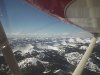
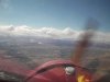
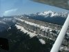
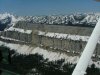
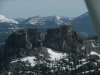
Anyone ever flown along Chinese Wall, Montana?
Came across this video and did a little research locating it on a map:
http://vimeo.com/56388260
Not sure if they were entirely legal (2k agl, cause the area appears to be national park), but sure looks like someplace I should check out someday.
Came across this video and did a little research locating it on a map:
http://vimeo.com/56388260
Not sure if they were entirely legal (2k agl, cause the area appears to be national park), but sure looks like someplace I should check out someday.

")