Hi, I would like some suggestions on what people would think was the best route to fly VFR from North Dakota to North Las Vegas Airport (KVGT) in a Cessna 152. Was thinking I would fly south to Texas then west to Phoenix then up to VGT. Still unsure how I would fly west since unsure how high I will need to be. Any help or suggestions would be greatly appreciated. Thanks.
You are using an out of date browser. It may not display this or other websites correctly.
You should upgrade or use an alternative browser.
You should upgrade or use an alternative browser.
Cessna 152 to fly ND to Las Vegas
- Thread starter NDpilot
- Start date
Mafoo
Cleared for Takeoff
where in ND are you taking off from?
jdhowe75
Pre-Flight
Direct!
BillTIZ
Final Approach
There is a good pass through the Rockies just South of Pueblo. There is an AWOS in the pass reporting the weather. La Veta Pass, plan on going through early in the day before the temps and winds kick up. The AWOS station is at about 10,000MSL, the floor of the pass, about 9,000MSL.
Farmington to Page still has some high terrain, maybe too much for a C150. Once through the pass at La Veta, you can go south to lower terrain via Taos and Sante Fe.
Next option is Las Vegas NM and follow I-25 to Sante Fe, and ABQ, head west to Winslow and Flagstaff. There was a nice Mex resturant on the field at Wnslow.
Last edited:
Captain
Final Approach
Direct!
Ya know what...I bet that routing would be approved!
Tom-D
Taxi to Parking
- Joined
- Feb 23, 2005
- Messages
- 34,740
- Display Name
Display name:
Tom-D
I would go my own nav direct to Heber UT. fly down the valley to the hole in the wall, thru the canyon to Orem or Provo. catch I-15 to VGT>
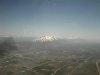
here is what the Wasatch range looks like from 10,000' headed into Salt Lake from the north west. the tops are 14,000' just south of Salt lake. a bit south of Provo they are only 5000' between Hanksvill VOR and the I-15 corridor.
here is what the Wasatch range looks like from 10,000' headed into Salt Lake from the north west. the tops are 14,000' just south of Salt lake. a bit south of Provo they are only 5000' between Hanksvill VOR and the I-15 corridor.
Attachments
Last edited:
Tom-D
Taxi to Parking
- Joined
- Feb 23, 2005
- Messages
- 34,740
- Display Name
Display name:
Tom-D
Why would you want to go that far east?There is a good pass through the Rockies just South of Pueblo. There is an AWOS in the pass reporting the weather. La Veta Pass, plan on going through early in the day before the temps and winds kick up. The AWOS station is at about 10,000MSL, the floor of the pass, about 9,000MSL.
Farmington to Page still has some high terrain, maybe too much for a C150. Once through the pass at La Veta, you can go south to lower terrain via Taos and Sante Fe.
Next option is Las Vegas NM and follow I-25 to Sante Fe, and ABQ, head west to Winslow and Flagstaff. There was a nice Mex resturant on the field at Wnslow.
GCA319
Cleared for Takeoff
I'm a wuss, so I'd go with whatever routing kept me over the flattest/lowest terrain without going too far out of the way. The south to TX or the plains of Eastern NM than west across NM and AZ (I-40 corridor) is a route I have done many times (minus the South to TX part). Once west of FLG, terrain shouldn't be much of an issue (just stay close to I-40), but be sure to check and re-check DA beetween just east of ABQ and FLG. That area is hot in the summer and for the most part >5000 MSL. If you want a challenge, you can cross the rockies, but don't try it without an experienced mountain pilot in the airplane.
Last edited:
Tom-D
Taxi to Parking
- Joined
- Feb 23, 2005
- Messages
- 34,740
- Display Name
Display name:
Tom-D
I'm a wuss, so I'd go with whatever routing kept me over the flattest/lowest terrain without going too far out of the way. The south to TX or the plains of Eastern NM than west across NM and AZ (I-40 corridor) is a route I have done many times (minus the South to TX part). Once west of FLG, terrain shouldn't be much of an issue (just stay close to I-40), but be sure to check and re-check DA beetween just east of ABQ and FLG. That area is hot in the summer and for the most part >5000 MSL. If you want a challenge, you can cross the rockies, but don't try it without an experienced mountain pilot in the airplane.
Do you realize Flag is 7000' ?
Google maps are your friend look at the salt lake and Heber area. easy to get across the rocks there.
cirrusmx
Line Up and Wait
- Joined
- Dec 20, 2011
- Messages
- 794
- Location
- Boston, Massachussetts
- Display Name
Display name:
campoalavista
from abq to las vegas i got routed through some airways that follow I-40. you pass flagstaff and go through the peach springs vor. if i remember correctly the mea was 10000 ft. its a pretty cool flight specially going back were they route you closer to lake mead and the grand canyon.
markb5900
Line Up and Wait
- Joined
- Feb 23, 2005
- Messages
- 737
- Display Name
Display name:
Mark B
If you want to avoid the mountains.
I would go south to somewhere in west KS, then go direct to ABQ, then direct to PHX, then turn north around the range to Havasu, then direct to north Vegas.
That route will keep you out of the "real" mountains, but take you quite a bit longer.
Around PHX, they REALLY REALLY REALLY don't like VFR planes in the airspace, so just avoid it to the north and follow the mountain range, then turn north when west of it to go to Havasu.
BillTIZ
Final Approach
Why would you want to go that far east?
Not so east, just pretty much south to a point to go west.
I had not flown the I-80 to Heber and Provo route.
denverpilot
Tied Down
Around PHX, they REALLY REALLY REALLY don't like VFR planes in the airspace, so just avoid it to the north and follow the mountain range, then turn north when west of it to go to Havasu.
I've had no trouble with VFR around PHX. I'm pretty sure their defense mechanism is due to the massive Chinese speaking flight schools in the area. The insanity level at KDVT can get pretty high. "I can make a short approach and get out of the way" can fix many evils there.
The controllers might even offer to kiss you when there seven aircraft all barely understanding their instructions in the pattern start doing something screwy and they all catch the contagion to do wild things, and you offer to quickly give them one less target to deal with.
")
KLAS is far more cranky about VFR traffic than KPHX.
Tom-D
Taxi to Parking
- Joined
- Feb 23, 2005
- Messages
- 34,740
- Display Name
Display name:
Tom-D
Not so east, just pretty much south to a point to go west.
I had not flown the I-80 to Heber and Provo route.
It's easier and can be done lower by going west thru Spearfish S.D. Casper Wy, Rowlins Wy, Rocksprings Wy., Salt Lake, and the I-15 corridor than going way out of the way by going way south, then west.
yakdriver
Cleared for Takeoff
- Joined
- Aug 29, 2011
- Messages
- 1,200
- Location
- Twin Falls, Idaho
- Display Name
Display name:
yellow peril
It's easier and can be done lower by going west thru Spearfish S.D. Casper Wy, Rowlins Wy, Rocksprings Wy., Salt Lake, and the I-15 corridor than going way out of the way by going way south, then west.
You can do that route at 8500' or even less. Good to do early in the morning if possible. Don
COFlyBoy
Line Up and Wait
Around PHX, they REALLY REALLY REALLY don't like VFR planes in the airspace, so just avoid it to the north and follow the mountain range, then turn north when west of it to go to Havasu.
Nah, I got cleared right over the top of PHX while VFR following the published VFR transition. They didn't gripe a bit.
It's easier and can be done lower by going west thru Spearfish S.D. Casper Wy, Rawlins Wy, Rocksprings Wy., Salt Lake, and the I-15 corridor than going way out of the way by going way south, then west.
That the one I'd use from either Dakota.
My wife and I are taking off from Fort Collins to Cedar City, UR tomorrow in the Jabiru. Weather looks good and I'm planning pretty much direct. KFNL - RLG - BJC - CYN - KCDC - 3:40