CDFA Typo? (BNA VOR DME Rwy 13)

HPNPilot1200

En-Route
Joined
Jul 6, 2005
Messages
2,662
Location
Huntington Beach, CA
Display Name

Display name:
Jason
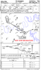
We flew this approach in the sim today... does anyone else have a problem with the CDFA that is published? The math doesn't add up...

For easy reference, a 3.12 degree glidepath is approximately 331 ft/nm. Our conclusion was that it is supposed to read 5.5 NM from the VOR, not MA13. Or put another way, 4.6 NM from MA13.

attachment.php
 

Attachments

  • IMG_0172.PNG
    IMG_0172.PNG
    130.6 KB · Views: 109
Last edited:
On VOR and NDB approaches (with or without GPS overlay) where the MAP is the navaid on the airport, the runway end of the final approach segment (i.e., the missed approach point) in the GPS database is placed at the approach end of the runway, not the navaid. You'd have to ask Wally Roberts why they do it this way, but they do. My guess is that makes the LNAV+V vertical guidance work properly, but that's just a guess.

Thus, what you see on the chart you posted is correct. You'll also see this on the VOR 5 at KSBY (no overlay) and the NDB or GPS 34 at KCGE.
 
331 * 5.5 + 567 ~= 2400. You want to be Continuously Descending on Final Approach to the start of the runway, not to the VOR.
 
On VOR and NDB approaches (with or without GPS overlay) where the MAP is the navaid on the airport, the runway end of the final approach segment (i.e., the missed approach point) in the GPS database is placed at the approach end of the runway, not the navaid. You'd have to ask Wally Roberts why they do it this way, but they do. My guess is that makes the LNAV+V vertical guidance work properly, but that's just a guess.

Thus, what you see on the chart you posted is correct. You'll also see this on the VOR 5 at KSBY (no overlay) and the NDB or GPS 34 at KCGE.

Distance from FAF to MAP is 5.1 NM.

5.5 NM to MAP (charted CDFA) is prior to the FAF (not as depicted after FAF) and results in a red over red indication on the VASI. Something doesn't seem right about that.
 
Last edited:
From Jeppesen:

Excellent eyes. I ran a new VNAV calculator for this approach, and the actual distance VNAV TOD-MAP (MA13) should be 5.0 NM. The charting department did not subtract the 0.5 NM distance MAP-DT.
The level segment FAF-TOD is only 0.1 NM.

I have an urgent request in to have this corrected.
 
On VOR and NDB approaches (with or without GPS overlay) where the MAP is the navaid on the airport, the runway end of the final approach segment (i.e., the missed approach point) in the GPS database is placed at the approach end of the runway, not the navaid. You'd have to ask Wally Roberts why they do it this way, but they do. My guess is that makes the LNAV+V vertical guidance work properly, but that's just a guess.

Thus, what you see on the chart you posted is correct. You'll also see this on the VOR 5 at KSBY (no overlay) and the NDB or GPS 34 at KCGE.

Those two IAPs are quite different than the BNA VOR/DME 13. The BNA VOR/DME has a FAF and a MAP 0.5 miles prior to the runway. The two IAPs you cite are On-Airport, No-FAF IAPs, which must use the facility as the MAP.
 
Using that math it would appear that one should start descending 5.5NM from the threshold which is 5.0NM from MA13.

This is the FAA chart, which shows 3.03 degrees. That angle is required to clear the 1,500' 3.2 DME step-down fix.

The Jepp chart is wrong.

Two requirements for VNAV overlay: the path must not violate and step-down fix in the final segment and must meet the TCH at the approach end of the runway.

This is not an overlay IAP so the vertical path becomes problematic for most avionics.
 

Attachments

  • FAA BNA VORDME 13.pdf
    259.3 KB · Views: 3
The Jep chart is a year old and out-of-date (not valid). I imagine the current Jep chart is correct.

I see he is using it on a sim so that is fine, just no point in comparing it to current charts.

Checking the math, the numbers work out if you correct "5.5 nm to MA13" to "5.0 nm to MA13" as the JepRep indicated. Did he not catch that this is an old chart, do they consider it "urgent" to correct an outdated chart, or did the error carry over to a current chart?
 
Last edited:
This is the FAA chart, which shows 3.03 degrees. That angle is required to clear the 1,500' 3.2 DME step-down fix.

The Jepp chart is wrong.

If you follow a 3.03 degree glidepath, that will put you at 31 feet above TDZ at the threshold, not the published TCH of 45 feet. Here's the math I used:

322 * 2.8 = 901.6
1500 - 901.6 = 598.4
598.4 - 567 = 31.4
 
Last edited:
The Jep chart is a year old and out-of-date (not valid). I imagine the current Jep chart is correct.

Actually it is a current (valid) chart as of cycle 05-2012. The date at the top is only when the chart was published. It is valid until deleted or replaced.
 
The difference in VDA's is rather negligible but when I calculated the VDA from the stepdown fix at 1500 feet to the threshold, I came up with 338 ft/nm or 3.18 degrees.

If you follow a 3.03 degree glidepath, that will put you at 31 feet above TDZ at the threshold, not the published TCH of 45 feet. Here's the math I used:

At the risk of being an uppidity new guy :wink2:, it does work out to 45' exactly.

2.8 * 6000 * sin 3.03 = 888' (we will use sin instead of tan for precision as DME is slant range)
1500 - 888 = 612 - 567 = 45'
 
Actually it is a current (valid) chart as of cycle 05-2012. The date at the top is only when the chart was published. It is valid until deleted or replaced.

Thanks, I am not familiar with Jep procedures and assumed it was similar to FAA (NACO) charts cycle.
 
At the risk of being an uppidity new guy :wink2:, it does work out to 45' exactly.

2.8 * 6000 * sin 3.03 = 888' (we will use sin instead of tan for precision as DME is slant range)
1500 - 888 = 612 - 567 = 45'

I am using 6076' = 1 nm and tan instead of sin since the gradient is feet per nautical mile (opposite over adjacent).
 
I am using 6076' = 1 nm and tan instead of sin since the gradient is feet per nautical mile (opposite over adjacent).

My bad on the nautical mile, too used to doing it my head that way :confused:
 
I am using 6076' = 1 nm and tan instead of sin since the gradient is feet per nautical mile (opposite over adjacent).

My error on nm notwithstanding, I guess what it really boils down to is that the 3.03 is on the non-precision approach and you are not following a glideslope down to the runway, you are leveling out 513' above it. As aterpster noted, the 3.03 is to clear a step-down fix, not carry you to the threshold.

As an engineer myself, I am loathe to automatically assume that the designer of this approach or the chartmaker made an error like this. Here is a possiblity. CLAIR is a known point with known coordinates. The threshold has known coordinates. The designer would have had the actual distance in feet between those points. I am sure we can discover the coords also but I am not going to bother trying. Anyway, would the actual distance between those points that would yield 3.03 and TCH 45 be one that would round to the distances shown on the chart? The answer is yes. That exact distance would be 5.567 nm. It would certainly round to 5.6 nm, especially given that it is broken in three parts on the chart.
 
As an engineer myself, I am loathe to automatically assume that the designer of this approach or the chartmaker made an error like this. Here is a possiblity. CLAIR is a known point with known coordinates. The threshold has known coordinates. The designer would have had the actual distance in feet between those points. I am sure we can discover the coords also but I am not going to bother trying. Anyway, would the actual distance between those points that would yield 3.03 and TCH 45 be one that would round to the distances shown on the chart? The answer is yes. That exact distance would be 5.567 nm. It would certainly round to 5.6 nm, especially given that it is broken in three parts on the chart.

OK, I said I wasn't going to but...

http://www.ngs.noaa.gov/AERO/uddf/SOUTHERN/TENNESSEE/BNA__05F.F77

http://maps.google.com/maps?q=36+08...693381&sspn=21.658345,28.125&t=h&safe=on&z=17

http://www.airnav.com/airspace/fix/CLAIR

http://www8.nau.edu/cvm/latlongdist.html

"Distance between 36 11'30"N 86 47'18"W and 36 8'23"N 86 41'36"W is
5.5677 nautical miles"

There is a tiny bit of rounding in how I had to enter the coords in that calculator but my guess is that 3.03 is the exact slope to 45' above TDZE and any error that we perceive is due to rounding the distance shown on the approach chart.
 
Last edited:
My error on nm notwithstanding, I guess what it really boils down to is that the 3.03 is on the non-precision approach and you are not following a glideslope down to the runway, you are leveling out 513' above it. As aterpster noted, the 3.03 is to clear a step-down fix, not carry you to the threshold.

By definition, a CDFA should provide a constant descent from the FAF to 50 feet above the TDZ without any level-offs (see AC 120-108). Even though the MDA is your lowest authorized altitude on the final segment until you acquire the runway environment, the thought is that if you have the runway environment in sight at or before the point where the MDA intersects the CDFA/VNAV path, then you will be stabilized and can continue the approach and landing safely. The advisory circular introduces the concept of a "DDA" or "Derived Decision Altitude" which is that point where the MDA intersects the CDFA/VNAV path.

AC 120-108 said:
Definition of CDFA. CDFA is a technique for flying the final approach segment of an NPA as a continuous descent. The technique is consistent with stabilized approach procedures and has no level-off. A CDFA starts from an altitude/height at or above the FAF and proceeds to an altitude/height approximately 50 feet (15 meters) above the landing runway threshold or to a point where the flare maneuver should begin for the type of aircraft being flown.
(My emphasis in bold)
The designer would have had the actual distance in feet between those points. I am sure we can discover the coords also but I am not going to bother trying. Anyway, would the actual distance between those points that would yield 3.03 and TCH 45 be one that would round to the distances shown on the chart? The answer is yes. That exact distance would be 5.567 nm. It would certainly round to 5.6 nm, especially given that it is broken in three parts on the chart.

Good point, rounding would certainly change things slightly.
 
I think the calculation goes from the other direction. The anchor point is at the threshold at the TCH and the angle of the glidepath is adjusted to clear the step down point. A Baro VNAV path is a curved line in space where the glideslope angle with respect to a tangent to a radial to the center of the earth is a constant, so the calculation is more complex than using simple trigonometry.
 
OK, I said I wasn't going to but...

http://www.ngs.noaa.gov/AERO/uddf/SOUTHERN/TENNESSEE/BNA__05F.F77

http://maps.google.com/maps?q=36+08...693381&sspn=21.658345,28.125&t=h&safe=on&z=17

http://www.airnav.com/airspace/fix/CLAIR

http://www8.nau.edu/cvm/latlongdist.html

"Distance between 36 11'30"N 86 47'18"W and 36 8'23"N 86 41'36"W is
5.5677 nautical miles"

There is a tiny bit of rounding in how I had to enter the coords in that calculator but my guess is that 3.03 is the exact slope to 45' above TDZE and any error that we perceive is due to rounding the distance shown on the approach chart.

The equation the TERPS would use to determine the altitude of the Baro-VNAV altitude at a fix or distance from the threshold is given by: e^((DZ*tan(angle*PI/180))/r)*(r+LTPelev+TCH)-r

Where:

DZ is the distance in feet from the threshold to the fix
Angle is the glidepath angle in degrees (3.03 degrees)
r is the distance to the center of the earth in feet (20,890,537)
LTPelev is Landing Threshold Elevation (approximately 567 feet) in ft MSL
TCH is the Threshold Crossing Height in feet (45 feet)

Using your distance of 5.5677 NM and converting it to feet by multiplying it by 6076.11 ft/NM yields 33,830 feet for DZ.

The calculated altitude of the glidepath at that distance is 2403 feet, rounded to the nearest foot. If you change the glidepath angle to 3.02 degrees, the altitude is 2397 feet MSL, so 3.03 is the correct angle to the nearest hundredth of a degree.
 
I think the calculation goes from the other direction. The anchor point is at the threshold at the TCH and the angle of the glidepath is adjusted to clear the step down point. A Baro VNAV path is a curved line in space where the glideslope angle with respect to a tangent to a radial to the center of the earth is a constant, so the calculation is more complex than using simple trigonometry.

Wow, much more complex than I thought! I never considered they would consider the (idealized) curvature of the Earth over such a relatively short distance. Good job working it out in your following post. Thanks!
 
Back
Top