kenjr
Line Up and Wait
...quick question for a flight tomorrow...
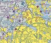
First time through the DFW Bravo and I'll be landing at 52F which is under the 1200' shelf. There's a class D airport very close by (KAFW).
Something that's got me confused (first time I've seen this). When you are zoomed out on the VFR sectional the shelf shows 110/30. But in ForeFlight when I zoom in I get the DFW Fly (high detail) and it shows 1200' over the top of 52F? What's the deal here?
What's the usual protocol departing in this situation? 52F has it's own CTAF of course so I'd have to use that to get out of there but field elevation is 600' so I'd have pretty much no time once I get off the ground to call and ensure I had clearance into the Bravo.
I'm guessing call DFW departure or approach and get a clearance/TXPR code prior to departing, use 52F CTAF to get out of there, immediately switch to DFW approach during the climb and follow whatever directions they give with the clearance?
Also curious - when arriving with the airport that close under the shelf, how do they normally handle the handoff to the CTAF? Pattern Altitude is 1600' which is in the Class B so not sure how that would go?
Anyway, maybe this is all a moot point because the actual shelf is 2999' and as long I'm under that I'll have time to contact DFW on my way out of 52F?
Thanks in advance!
Attachments
Last edited:
") But back in the pre-satellite days, I tended to check with Flight Service/Watch for more extensive coverage than just checking the individual automated systems I passed along the way.
But back in the pre-satellite days, I tended to check with Flight Service/Watch for more extensive coverage than just checking the individual automated systems I passed along the way.