BP is not the only one with a blowout

Clark1961

Touchdown! Greaser!
Joined
Jun 7, 2008
Messages
17,737
Display Name

Display name:
Display name:
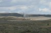
The first shot is of another operator's "minor" problem somewhere in southern Wyoming. It's a coalbed methane field so the water (which is blowing everywhere) is fairly fresh.

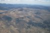
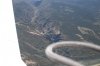
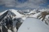
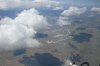
The other shots are of my flight today. Wanna play "name the locations"?
 

Attachments

  • SDC10481.JPG
    SDC10481.JPG
    3.2 MB · Views: 85
  • SDC10487.JPG
    SDC10487.JPG
    3.1 MB · Views: 33
  • SDC10491.JPG
    SDC10491.JPG
    3.3 MB · Views: 33
  • SDC10501.JPG
    SDC10501.JPG
    3.3 MB · Views: 20
  • SDC10512.JPG
    SDC10512.JPG
    3.1 MB · Views: 28
The airport is Colorado Springs....

And the third picture is Royal Gorge....

The mine might be Climax, but not sure about that....

So then using my power of deduction, is the pass Monarch Pass?
 
Last edited:
The airport is Colorado Springs....

Correct. What was the altitude?

And the third picture is Royal Gorge....

Correct.

The mine might be Climax, but not sure about that....

Not so correct. A bit south and east of the moly pit. Another guess might be a gamble but then again it might be legal to gamble...:smilewinkgrin:

So then using my power of deduction, is the pass Monarch Pass?

The pass is un-named on the chart. The pass followed a t-n-g at Silver West. I flew a bit south and then turned west - entered the San Louis valley directly over the dunes.
 
Correct. What was the altitude?
Hmmm... I can't see your altimeter in the picture.

Not so correct. A bit south and east of the moly pit. Another guess might be a gamble but then again it might be legal to gamble...:smilewinkgrin:
OK, next guess is the Victor area. I would say that's more than a "bit" southeast but that's a pretty big mine and I can't think of many others.
 
Hmmm... I can't see your altimeter in the picture.

And here I thought you jet drivers could estimate altitudes by squinting over your thumb. Another illusion shattered. I had the Dakota cranked up about as high as I could legally go without being on a clearance. It was nice to see 146 TAS even if I was burning 12 gph to do it.

OK, next guess is the Victor area. I would say that's more than a "bit" southeast but that's a pretty big mine and I can't think of many others.

Well, it's more than a "bit" southeast in the t-Dak but I'm sure it's only a bit in the twin Cessna...anyway you are correct, it's the Cripple Creek/Victor mine.
 
And here I thought you jet drivers could estimate altitudes by squinting over your thumb. Another illusion shattered. I had the Dakota cranked up about as high as I could legally go without being on a clearance. It was nice to see 146 TAS even if I was burning 12 gph to do it.
Well, I was thinking it looked like a pretty normal altitude for us... as we are descending into KAPA. :)
 
Depending on what time you took the pic of Royal Gorge, I might be in the pic. I was over the Gorge today around 11:00am in a 172. I have a similar picture, but it is much taken much closer to the ground :smile:
 
Back
Top