Let'sgoflying!
Touchdown! Greaser!
Ignore if discussed (I haven't been following all threads).
Or if you think such thoughts silly.
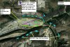
See attached aerial photo with attached scratch marks.
Taking off, its the kind of place I like to consider the W.C.S.(cenarios).....
There is a good area (I presume GoogleEarths satphotos are pretty current) just off the end, and north. Circled yellow.
I can't recall the distances or how high we normally can get at each location, but I might deadstick straight ahead......til there is no good place ahead - at which point I should have enough altitude (maybe even 500'?) for a turn to the circled field. The dashed green is a proposed climb out to make the turn more successful.
Anyone think the river would be survivable?
Or if you think such thoughts silly.
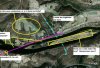
See attached aerial photo with attached scratch marks.
Taking off, its the kind of place I like to consider the W.C.S.(cenarios).....
There is a good area (I presume GoogleEarths satphotos are pretty current) just off the end, and north. Circled yellow.
I can't recall the distances or how high we normally can get at each location, but I might deadstick straight ahead......til there is no good place ahead - at which point I should have enough altitude (maybe even 500'?) for a turn to the circled field. The dashed green is a proposed climb out to make the turn more successful.
Anyone think the river would be survivable?
")
