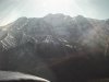
I've made the trip from Mpls to SLC several dozen times with a few in every season, and frankly I haven't seen much correlation between the time of year and the winds/clouds save for mid to late winter when the clouds are more prevalent. If you follow I-80 most of the way (SNY/MBW->V6) the terrain is the most "unmountainlike" mountainous area across the Great Divide. From the eastern foothills to just east of Ogden the elevations are in the 6000-8000 MSL range with mostly wide open mesas. And the lack of terrain generally means there won't be big changes in the weather every 20-50 nm like you can get in the rougher places. IOW, as long as your schedule is flexible I think you could make this trip VFR in a light plane almost any time of the year.
That said, late fall / early winter as well as late spring can mean high winds which will both slow you down considerably and bounce you around quite a bit so if you went then, you'd want to pick a time when the wind forecast was fairly benign.
One final tip, if it is windy you want to stay on the downwind side of any valley or canyon for two reasons. One is that you will likely encounter rising air there which makes you go faster (your plane is essentially flying downhill). The other is that if you do need to turn around you will make your turn into the wind which shortens the radius considerably (if a famous baseball player knew this, he'd still be alive).
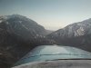
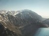
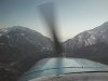
BTW I-80 swings well to the south just before you get to the one and only rather tall ridgeline on the east side of the valley which contains SLC and OGD. You could go that way and stay pretty low, but you shouldn't have any trouble following V6 most of the way and sneaking through the canyon that runs east from a few miles south of the Ogden airport. Or you could follow I80 to where I84 splits off and follow that into Ogden. Keep in mind that when following canyons and freeways you will occasionally turn a corner and find your way blocked by low clouds even when you were in CAVU just before the turn. Also you will find that the way looks like a dead end when the road you are following snakes through a pass because you can't "see around the corner".
 There's about a two month window from the 1st week of September till about the middle of November. Just about the most benign weather across the Rocky Mountains. Also, the daytime temps are down and DA becomes less of an issue, but the OAT is still warm enough to be comfortable.