Blueangel
Line Up and Wait
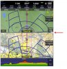
I tried all the EFB and my buddy turned me onto Avare even though it only runs on android based tablets. Still Avare is FREE so buying an Android tablet is cheaper in the long run to have free EFB for instrument plates and flying. Check it out:
http://apps4av.com
Buying a $100-200 android tablet is cheaper in the long run than spending $150+ each year for a subscription fee based app!
http://apps4av.com
Buying a $100-200 android tablet is cheaper in the long run than spending $150+ each year for a subscription fee based app!