You are using an out of date browser. It may not display this or other websites correctly.
You should upgrade or use an alternative browser.
You should upgrade or use an alternative browser.
Beached plane
- Thread starter TangoWhiskey
- Start date
wby0nder
Cleared for Takeoff
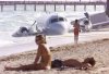
Anybody know the story behind this picture? (I'm referring to what's in the background, guys...)
Scientists still are uncertian... Red Tides caused by algae blooms may cause the beasts to bacome sick. Others think microbial illnesses, parasites, or even pollution lead to this sort of behavior. Whatever the case, it's very rare that once disoriented and "beached" they are ever succesfully returned to their natural habitat.
etsisk
En-Route
looks shopped to me, but what do I know? ")
skyflyer8
Line Up and Wait
- Joined
- Nov 27, 2006
- Messages
- 967
- Display Name
Display name:
skyflyr
Belongs on the Modified Airliner Photos site if it's not there already.
looks shopped to me, but what do I know?
Why do you think that? Looks like a Convair freight hauler that had one feathered and barely made the beach. The Bahamas/Caribbean freight dogs going down isn't exactly a rarity. In the last year there's been a Beech 18 (remember the dude sitting in the cockpit of the disintigrated plane?) and a DC-3 that have gone in around here.
etsisk
En-Route
not saying the plane didn't crash somewhere, just not sure that it crashed there. Line where the plane hits the beach, shadows wrt the shadows on the pier, it just looks funny. Might be real, but it looks funny.
not saying the plane didn't crash somewhere, just not sure that it crashed there. Line where the plane hits the beach, shadows wrt the shadows on the pier, it just looks funny. Might be real, but it looks funny.
Hmmmmmm...., I'm not seeing any incongruities in light.
Dave Krall CFII
Final Approach
- Joined
- Mar 4, 2005
- Messages
- 5,022
- Location
- Seattle WA
- Display Name
Display name:
Dave Krall CFII SEL SES, Cmcl HELI
not saying the plane didn't crash somewhere, just not sure that it crashed there. Line where the plane hits the beach, shadows wrt the shadows on the pier, it just looks funny. Might be real, but it looks funny.
I doubt that was its landing line as it sits, if that's what you mean. The waves would have sloshed it around and probably settled it some fairly quickly unless there's solid like rock underneath the sand.
ScottM
Taxi to Parking
- Joined
- Jul 19, 2005
- Messages
- 42,529
- Location
- Variable, but somewhere on earth
- Display Name
Display name:
iBazinga!
I an find nothing about it in US news. One would think there would be some coverage
Teller1900
En-Route
I an find nothing about it in US news. One would think there would be some coverage
Maybe it's a few years old. Or if everyone lived, they not have said more than a few paragraphs about it.
ScottM
Taxi to Parking
- Joined
- Jul 19, 2005
- Messages
- 42,529
- Location
- Variable, but somewhere on earth
- Display Name
Display name:
iBazinga!
True. The only page I could find was a blog where this exact picture was posted and claimed to be Miami a few days ago. Someone put a link that was broken to a Reuters story about the landing. Searching Reuters showed no story nor did I find one on Google. Given that Henning is in the suburbs of Miami and did not stumble across news on this yet I find the claim in the blog highly suspect. That does not mean I think it is a fake picture, not yet anyways, just that there is still more to be uncovered.Maybe it's a few years old. Or if everyone lived, they not have said more than a few paragraphs about it.
Jeff S KDTW
Pre-takeoff checklist
- Joined
- Apr 28, 2007
- Messages
- 148
- Display Name
Display name:
Jeff S KDTW
Is that a Beechcraft? Get it? (sorry)
(sorry)wby0nder
Cleared for Takeoff

Greg Bockelman
Touchdown! Greaser!
- Joined
- Feb 23, 2005
- Messages
- 11,111
- Location
- Lone Jack, MO
- Display Name
Display name:
Greg Bockelman
The picture is old. It was "debated" in another forum several months (well, a long time) ago. Someone came up with the story on it but I forgot what it was. But it was determined that the picture was legit.
TangoWhiskey
Touchdown! Greaser!
The picture is old. It was "debated" in another forum several months (well, a long time) ago. Someone came up with the story on it but I forgot what it was. But it was determined that the picture was legit.
I have NO context (date, place, or otherwise) for this photo. It was in a collection of photos in an email titled "things you won't see everyday" my sis-in-law sent me.
However, based on the comment above that it might be a Convair, I found this:
http://aviation-safety.net/database/record.php?id=20041204-0
Maybe? Or perhaps:
[EDITED: THIS IS THE RIGHT ONE, SEE ADDITIONAL MESSAGE BELOW WITH ANOTHER PICTURE FROM A DIFFERENT ANGLE]
http://aviation-safety.net/database/record.php?id=20011206-0&lang=en
Or, even this one, which "came to rest on on the beach in the surf line" (however, looking at a Google Maps photo of the departure airport, runway 8, beach, doesn't show a pier anywhere nearby, so that's doubtful to be the correct record):
http://aviation-safety.net/database/record.php?id=19970630-0
Last edited:
TangoWhiskey
Touchdown! Greaser!
OK, guys, got it! It's the middle link in my previous message. The prop bends and everything match up:
http://www.airliners.net/open.file/0205673/L/
http://maps.google.com/maps?f=q&hl=...7&spn=0.037932,0.086002&t=h&z=14&om=1&layer=t
http://www.airliners.net/open.file/0205673/L/
He ALMOST made it back to FLL.... you can see the pier and the airport in this Google Map:December, 2001:
N582HG (cn 46) Looking like a beached whale, the aircraft that ditched in the Atlantic on Dec. 6 after departing FLL.
http://maps.google.com/maps?f=q&hl=...7&spn=0.037932,0.086002&t=h&z=14&om=1&layer=t
Last edited:
ScottM
Taxi to Parking
- Joined
- Jul 19, 2005
- Messages
- 42,529
- Location
- Variable, but somewhere on earth
- Display Name
Display name:
iBazinga!
OK, guys, got it! It's the middle link in my previous message. The prop bends and everything match up:
http://www.airliners.net/open.file/0205673/L/
He ALMOST made it back to FLL.... you can see the pier and the airport in this Google Map:
http://maps.google.com/maps?f=q&hl=...7&spn=0.037932,0.086002&t=h&z=14&om=1&layer=t
In the year 2001 hence why it was not showing up in news searches.
Teller1900
En-Route
OK, guys, got it! It's the middle link in my previous message. The prop bends and everything match up:
http://www.airliners.net/open.file/0205673/L/
He ALMOST made it back to FLL.... you can see the pier and the airport in this Google Map:
http://maps.google.com/maps?f=q&hl=...7&spn=0.037932,0.086002&t=h&z=14&om=1&layer=t
Impressive research. I think you did more searching for that than I did for most papers in college!
skyflyer8
Line Up and Wait
- Joined
- Nov 27, 2006
- Messages
- 967
- Display Name
Display name:
skyflyr
Okay, I'm convinced it was a real crash and I'll switch over to that camp. That is an interesting story.
I did find another similar picture on this web site (scroll way down). It shows the same orange shorts-wearing person. The web site claims that the photo is from the AP but who knows.
There are also a bunch of photos on airliners.net.
I still find it odd that people would be (or would be allowed to be) sunbathing next to an airplane wreck, so either the people in the foreground are Photoshopped in, or they're really die-hard sun worshippers.
TangoWhiskey
Touchdown! Greaser!
I still find it odd that people would be (or would be allowed to be) sunbathing next to an airplane wreck, so either the people in the foreground are Photoshopped in, or they're really die-hard sun worshippers.
Especially in December!! Of course, it was south Florida, so it was probably mid to upper 80's!
I have NO context (date, place, or otherwise) for this photo. It was in a collection of photos in an email titled "things you won't see everyday" my sis-in-law sent me.
However, based on the comment above that it might be a Convair, I found this:
http://aviation-safety.net/database/record.php?id=20041204-0
Maybe? Or perhaps:
[EDITED: THIS IS THE RIGHT ONE, SEE ADDITIONAL MESSAGE BELOW WITH ANOTHER PICTURE FROM A DIFFERENT ANGLE]
http://aviation-safety.net/database/record.php?id=20011206-0&lang=en
Or, even this one, which "came to rest on on the beach in the surf line" (however, looking at a Google Maps photo of the departure airport, runway 8, beach, doesn't show a pier anywhere nearby, so that's doubtful to be the correct record):
http://aviation-safety.net/database/record.php?id=19970630-0
Not the first one as it still had its 2800 radials according to the report, the photo aircraft had turbines.
Not the second one as it ditched southbound, and if the plane was on Sunny Isles beach, the one in the photo was facing North. As well, if the plane in the pic with the report was the one they were identifying, it had polished rather than painted nacelles.
The third one, again, had R-2800s
OK, guys, got it! It's the middle link in my previous message. The prop bends and everything match up:
http://www.airliners.net/open.file/0205673/L/
He ALMOST made it back to FLL.... you can see the pier and the airport in this Google Map:
http://maps.google.com/maps?f=q&hl=...7&spn=0.037932,0.086002&t=h&z=14&om=1&layer=t
You're right, looks like it, they must have spun around in the landing.
TangoWhiskey
Touchdown! Greaser!
You're right, looks like it, they must have spun around in the landing.
Or the accident report was wrong... but I suspect you're right, it could explain the tail being broke off like that.
I still find it odd that people would be (or would be allowed to be) sunbathing next to an airplane wreck, so either the people in the foreground are Photoshopped in, or they're really die-hard sun worshippers.
This is So FL we're talking about, all sorts of stuff washes up on our beaches, we don't care, we share our beaches, not like them snobs up north with their "Private Beaches".
jwriteclub
Line Up and Wait
The planes not going anywhere, why not enjoy the beach?
~ Christopher
~ Christopher