Argh! Chicago Approach ruins lakeshore route

flyingcheesehead

Touchdown! Greaser!
Joined
Feb 23, 2005
Messages
24,258
Location
UQACY, WI
Display Name

Display name:
iMooniac
FAA letter sent today... New arrival and approach procedures mean that flights into MDW will be crossing the lakeshore below the Bravo, between 2400 and 3000 MSL when MDW is landing 22L. RIGHT in the middle of the only good way to get past Chicago, the lakeshore route! Grrrrrrr!!!!!

https://www.faasafety.gov/files/gsl...014/Feb/85550/140130 C90 LTA Distribution.pdf

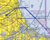
They say anywhere between Navy Pier and KGYY, between 2400 and 3000 MSL. Looking at the procedures, though, I've come up with the following illustration. Anywhere in the box here is fair game, so I'd expect heavy traffic anywhere from Soldier Field down to the plants.

attachment.php


How long 'til the Bravo is expanded again to encompass these arrivals and we lose the lakeshore entirely? Sigh... Where are you, AOPA?
 

Attachments

  • C90Lakeshore.jpg
    C90Lakeshore.jpg
    254.7 KB · Views: 457
The new RNAV 22L arrival to MDW starts 6 February. Anyone flying after that on the lakeshore should listen to MDW's ATIS. If they are landing 22L with the approach, I strongly suggest you stay AOB 2000 on the lake shore between downtown Chicago and the "hotels" location on the TAC.

I haven't heard anything about an airspace expansion, yet. I would guess the C gets extended to incorporate the arrival.
 
I don't see the issue. You can easily go below the traffic.
 
I thought there was a FAR that required them to keep traffic within the Bravo...
 
I don't understand the problem. I'm on a presumably VFR flight, I am squawking 1200, I am outside the B ring, I fly my plane from surface to 3599', I stay 1000' from any person or structure. What am I doing wrong?
 
If you think this is a big problem, you should try flying in LA. We have lots of Class B floors that go down low, and we fly below them, just watching for wake turbulence.
 
I thought there was a FAR that required them to keep traffic within the Bravo...

Only for the primary Class B airport, which is ORD.
Midway is in a Satillite Class C airport under the Class B.

And it would not be an FAR, it would be under an "Order".
 

Attachments

  • 140130 C90 LTA Distribution.pdf
    1.7 MB · Views: 19
Notice to Chicago TRACON. Starting since - oh, maybe 1920, VFR aircraft will be operating along the lakeshore transition route east of Midway airport. TRACON operations staff are strongly advised to route Midway traffic so as not to cause a safety hazard to VFR flights between surface and 3599' around the 15NM ring of the O'hare class B. Also includes airspace from surface to 2999' from Soldier field in the south, up to Lake Forest.
 
Glad I'm working on my IR. The lakeshore route was great and I got into flying again partially to travel on business to GYY.
 
Glad I'm working on my IR. The lakeshore route was great and I got into flying again partially to travel on business to GYY.

Why? They will still route you to KELSI.
 
MDW has been looking for a safe way to drive arrivals to 22L in IFR weather for years. This new arrival provides separation between arrivals and downtown Chicago. Unfortunately, it also creates a conflict with the lakeshore corridor. Arrivals to 22L on the RNAV arrival cross 3 NM east of SAILS at 3,000, and cross KEEEL at 2,400. From KEEEL arrivals will descend to the RNAV MDA.

The rest of the arrival doesn't seem to conflict with the VFR corridor. There is a transition over MIING (~3 south of MDW) eastbound with a 220ish degree left turn to final. That transition isn't allowed to descend below 4,000 until over the lake.

If you fly the lakeshore VFR route, listen to the MDW ATIS to find out if MDW is advertising RNAV 22L.
 
Why? They will still route you to KELSI.

KELSI is an IFR routing to circumnavigate approach airspace. Internal C90 arrivals and departures will get vectors to the airport and stay in-house.
 
Last edited:
MDW has been looking for a safe way to drive arrivals to 22L in IFR weather for years. This new arrival provides separation between arrivals and downtown Chicago. Unfortunately, it also creates a conflict with the lakeshore corridor. Arrivals to 22L on the RNAV arrival cross 3 NM east of SAILS at 3,000, and cross KEEEL at 2,400. From KEEEL arrivals will descend to the RNAV MDA.

The rest of the arrival doesn't seem to conflict with the VFR corridor. There is a transition over MIING (~3 south of MDW) eastbound with a 220ish degree left turn to final. That transition isn't allowed to descend below 4,000 until over the lake.

If you fly the lakeshore VFR route, listen to the MDW ATIS to find out if MDW is advertising RNAV 22L.

Good info to know. So - let's take it further. I'm in my spamcan, tootling along in VMC going up the lakeshore at a safe gliding altitude of 3000', which is right in the way of the 22L RNAV appr from MANLI to BAWJU. I'm listening to the ATIS and MDW is using the 22L RNAV, so there may be a conflict.

I'm VFR, squawking but not talking, and TRACON/APPR/Tower is talking to the arrival. My take on it is that this is back to 'see and avoid' for both parties. Since I'm not under positive control, what's going to happen to the RNAV 22L guy? Traffic advisory? Turn? Descend? Cancel IFR and proceed visual?(my vote, BTW)
 
Why? They will still route you to KELSI.

They even tried to send me to KELSI when I was coming in from the Southeast. (That was a mistake however, they had me confused with someone going to DPA or something).
 
Allow me point out the obvious.

If they have IFR arrivals to 22L at MDW in IMC, there won't be any VFR traffic in the lakeshore route.
 
Allow me point out the obvious.

If they have IFR arrivals to 22L at MDW in IMC, there won't be any VFR traffic in the lakeshore route.

Of course, just because there is no IMC in the lakeshore route doesn't mean that there won't be IFR traffic on approach for 22L.
 
Last edited:
If they are landing 22L with the approach, I strongly suggest you stay AOB 2000 on the lake shore between downtown Chicago and the "hotels" location on the TAC.

The biggest problem with this is wake turbulence. If you *cross* the vortex cores, you're going to get a violent pitch-down and go plop in the lake. That's likely what happened to the Cherokee that went down in the lake near MKE on the way to Oshkosh last summer. If you're at 1500-2000 feet and you go behind one of the MDW arrivals at 2400, you might have a very bad day.

I think my new technique might be to stay at 2500 down the lakeshore until just after Navy Pier, and climb to 3000 or more.

I haven't heard anything about an airspace expansion, yet. I would guess the C gets extended to incorporate the arrival.

At which point the lakeshore route really will be ruined... All they have to do is not answer you (an all-too-frequent occurrence with Chicago Approach) and you've gotta go feet wet.

Sadly, this is likely bound to happen anyway once Obama leaves office, if he chooses to move back to Chicago. If they center a small P-area or TFR on his house like they have with other ex-presidents, it'll extend out into the lake a few miles.
 
I don't see the issue. You can easily go below the traffic.

See my note above about wake turbulence. I hadn't ever really thought about it in terms of crossing because that really isn't in any of the FAA's documentation on the subject. They focus mostly on following a larger aircraft on or off a runway.

Then, that Cherokee went into the lake rather suddenly and mysteriously. Turns out he WAS talking to Milwaukee Approach, and they advised him of traffic inbound to 25L. When he had it in sight, he cut behind it and upon crossing its path suddenly went straight down. :eek:
 
I don't understand the problem. I'm on a presumably VFR flight, I am squawking 1200, I am outside the B ring, I fly my plane from surface to 3599', I stay 1000' from any person or structure. What am I doing wrong?

Nothing. And you can continue doing nothing wrong as the bigger plane's wake drops you into the lake.

I'd bet there will be numerous TCAS RA's that cause "deals" in ATC and there'll be another airspace grab before long. :frown2:
 
Glad I'm working on my IR. The lakeshore route was great and I got into flying again partially to travel on business to GYY.

The IR won't help you much... You'll get vectored all over creation. It's WAY easier to get past Chicago VFR on the lakeshore. At least, it was.
 
Arrivals to 22L on the RNAV arrival cross 3 NM east of SAILS at 3,000, and cross KEEEL at 2,400. From KEEEL arrivals will descend to the RNAV MDA.

The rest of the arrival doesn't seem to conflict with the VFR corridor. There is a transition over MIING (~3 south of MDW) eastbound with a 220ish degree left turn to final. That transition isn't allowed to descend below 4,000 until over the lake.

Do you work at C90? Do you think the graphic I provided in the OP is reasonably accurate?
 
Good info to know. So - let's take it further. I'm in my spamcan, tootling along in VMC going up the lakeshore at a safe gliding altitude of 3000', which is right in the way of the 22L RNAV appr from MANLI to BAWJU. I'm listening to the ATIS and MDW is using the 22L RNAV, so there may be a conflict.

The RNAV arrival you are referencing is obsolete. The new RNAV arrival's final approach course extends eastward from KEEEL, and southwest from KEEEL towards 22L. Its publish date is 6 February.


I'm VFR, squawking but not talking, and TRACON/APPR/Tower is talking to the arrival. My take on it is that this is back to 'see and avoid' for both parties. Since I'm not under positive control, what's going to happen to the RNAV 22L guy? Traffic advisory? Turn? Descend? Cancel IFR and proceed visual?(my vote, BTW)

A good question. I wish I had a good answer. A concern was raised here, which is why I imagine the letter went out. Air carriers will not cancel IFR, that is not an option. So while, technically, you could fly the corridor at originally published altitudes when this approach is in use, it's not a good idea.

Allow me point out the obvious.

If they have IFR arrivals to 22L at MDW in IMC, there won't be any VFR traffic in the lakeshore route.

I made the mistake of saying in IFR weather. There has been a push to move away from using ILS 31C circle 22L as a primary arrival procedure, especially when MDW is IFR.

Of course, just because there is no IMC in the lakeshore route doesn't mean that there won't be IFR traffic on approach for 22L.

Correct.

They even tried to send me to KELSI when I was coming in from the Southeast. (That was a mistake however, they had me confused with someone going to DPA or something).

Who is "they"? Approach? Center? If you are going to DPA, ARR, LOT, etc. the preferred route is EON JOT. Aircraft landing airports north of ORD that file "NO OVER WATER" in the remarks generally get the same routing.
 
Good info to know. So - let's take it further. I'm in my spamcan, tootling along in VMC going up the lakeshore at a safe gliding altitude of 3000', which is right in the way of the 22L RNAV appr from MANLI to BAWJU. I'm listening to the ATIS and MDW is using the 22L RNAV, so there may be a conflict.

I'm VFR, squawking but not talking, and TRACON/APPR/Tower is talking to the arrival. My take on it is that this is back to 'see and avoid' for both parties. Since I'm not under positive control, what's going to happen to the RNAV 22L guy? Traffic advisory? Turn? Descend? Cancel IFR and proceed visual?(my vote, BTW)

Well, since airliners can't cancel IFR in the air, they'll have to do something with 'em. However, I see this causing a lot of problems for ATC, and I'd expect an airspace grab soon.

I think that within 3 years, between this and Obama leaving office, the lakeshore will be impassable.
 
If anything, this notice would make me fly higher, not lower. I'd stay at or above 3400 until near the navy pier, when I'd drop down to 2900. Altitude = options.
 
Allow me point out the obvious.

If they have IFR arrivals to 22L at MDW in IMC, there won't be any VFR traffic in the lakeshore route.

Not so. Say the ceiling is between 3000-5000 MSL - They're still going to be using the arrival, and probably the approach, and you're perfectly legal VFR underneath.
 
Do you work at C90? Do you think the graphic I provided in the OP is reasonably accurate?

I'm in training at C90, I did 11 years at ZAU (FWA, GSH, OKK area) beforehand.

For the purposes of VFR flight, your graphic (and the one presented by my facility) is fine.
 
If anything, this notice would make me fly higher, not lower. I'd stay at or above 3400 until near the navy pier, when I'd drop down to 2900. Altitude = options.

Yup. And I don't think the 737's are gonna notice my wake. :rofl:
 
Well, since airliners can't cancel IFR in the air, they'll have to do something with 'em.


I think that within 3 years, between this and Obama leaving office, the lakeshore will be impassable.

Well, technically I think they could but they don't or won't for this situation of entering the C space. It would be up to the carriers ops manual, no? Surely airliners cancel IFR on the appr and proceed visual in some cases(Branson), but I do get your point.

Agreed that soon enough there will be little or no GA space around the east side of ORD. I will predict that in 10 years, there will be little or no GA space within 30NM of any metro hub.
 
Sadly, this is likely bound to happen anyway once Obama leaves office, if he chooses to move back to Chicago. If they center a small P-area or TFR on his house like they have with other ex-presidents, it'll extend out into the lake a few miles.
The one in Dallas only goes up to 1,500 AGL.
 
The one in Dallas only goes up to 1,500 AGL.

It used to be 3 miles and 3000 but Bush had it changed to what it is now. Also, it's completely enclosed in the class B.
 
I'm in training at C90, I did 11 years at ZAU (FWA, GSH, OKK area) beforehand.

Ah, cool! I've probably talked to you at some point then. :)

For the purposes of VFR flight, your graphic (and the one presented by my facility) is fine.

I didn't particularly like its grainy black-and-white nature - Looks like it was printed and scanned back in or something. No red lines on the one I linked to despite being referenced in the text. I also wanted to see where the arrivals really were. Navy Pier to Gary is a pretty wide swath.

Thanks!
 
Hey. Ya know what wouldda helped C90 here a whole lot?

If only there was an active Class D with tower there someplace on the lakefront, that could tell transitioning aircraft to get low when needed and watch for specific traffic and wake turbulence.

But Duh Mare made Chicago safer now.
 
Well, technically I think they could but they don't or won't for this situation of entering the C space.

Airliners cannot cancel IFR airborne.

It would be up to the carriers ops manual, no? Surely airliners cancel IFR on the appr and proceed visual in some cases(Branson), but I do get your point.

Nope - Southwest was cleared for a visual approach. A visual approach is an IFR operation.
 
Airliners cannot cancel IFR airborne.

Nope - Southwest was cleared for a visual approach. A visual approach is an IFR operation.

OK, works for me. I still don't know what they are going to do with the traffic if there is a TCAS warning or conflicting traffic with a VMC spamcan doing the coast route? Other than the 'cancel IFR' part, I still think the airliner will ask for a visual, and maintain their own separation with the aid of TRACON. They really don't like to go around unless it's absolutely needed.
 
I still don't know what they are going to do with the traffic if there is a TCAS warning or conflicting traffic with a VMC spamcan doing the coast route?

Well, if it's a TCAS warning, they're gonna do whatever the TCAS tells them to. Hopefully ATC will be more on top of it than that. Many of the arrivals will be vectored, but it's certainly going to be a challenge to ATC because they can't delay the turn onto the approach without putting the plane too close to downtown and ORD arrivals. They'll have to try to predict the situation far enough out that they can keep the MDW arrivals out over the lake if necessary.
 
Hey. Ya know what wouldda helped C90 here a whole lot?

If only there was an active Class D with tower there someplace on the lakefront, that could tell transitioning aircraft to get low when needed and watch for specific traffic and wake turbulence.

But Duh Mare made Chicago safer now.

And I predict that it'll be even "safer" as the airspace gets redesigned & the FLIBs get pushed further off-shore. If a FLIB goes down it's the pilot's problem. If there's a midair with a FLIB and an airliner, then it's a political problem.
 
It used to be 3 miles and 3000
I don't think that is true. I don't know how to look up the history of TFRs but here is a post from another forum in 2009 which states the top is 1,500 AGL.

9/2934 (#11): Tx.. Flight restriction. Dallas, texas. Pursuant to 49 usc 40103(b), the federal aviation administration (faa) classifies the airspace defined in this notam as 'national defense airspace'. Any person who knowingly or willfully violates the rules concerning operations in this airspace may be subject to certain criminal penalties under 49 usc 46307. Pilots who do not adhere to the following procedures may be intercepted, detained and interviewed by law enforcement/security personnel. Pursuant to title 14, section 91.141 of the code of federal regulations, aircraft flight operations are prohibited within the following area(s) unless otherwise authorized by atc within a 1 nmr of 325321n/0964835w or the cve085004.8 up to and including 1500 ft agl effective immediately until further notice. Wie until ufn.

http://forums.jetcareers.com/threads/fyi-ws-new-tfr-in-the-heart-of-dallas.82892/
 
Back
Top