Area of high pressure and FZ at the surface

Richard

Final Approach
Joined
Feb 27, 2005
Messages
9,076
Location
West Coast Resistance
Display Name

Display name:
Ack...city life
RE: two right panels of the attached chart

It appears the dominating area of high pressure centered over WY/CO and the freezing level at the surface are co-located. Why?
 

Attachments

  • ll_12_4_cl_new.gif
    ll_12_4_cl_new.gif
    63.7 KB · Views: 23
RE: two right panels of the attached chart

It appears the dominating area of high pressure centered over WY/CO and the freezing level at the surface are co-located. Why?
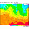
That's 6am out here and it's supposed to be clear tonight. I'm not at all surprised that the freezing level will be at the surface, in fact it's supposedly 36F here right now.
 
I figured a Coloradian would chime in. Thanks for the local wx. But I thought it curious that the blue squiggly line is closed...it resembles the isobars around the high.
 
I figured a Coloradian would chime in. Thanks for the local wx. But I thought it curious that the blue squiggly line is closed...it resembles the isobars around the high.

It also happens to be an area where the terrain is a higher altitude, and thus also colder.

It's chilly out here, too. Reports around 38-44ish. Was going to ride the motorcycle in, but 50 is about my limit for work pants. Any lower and I have to put on something warmer to cover my legs, and that gets annoying for the ~16 mile commute.
 
because the high is dumping high altitude, cold air, on the ground?
 
because the high is dumping high altitude, cold air, on the ground?

That would be my answer, and I'd also add that the High is pushing a stationary front out, which has another High in front of it of similar strength...traffic jam?:)
 
Coincidentally that's also more or less the area of highest ground elevations too.
 
Of the possible explanations so far I am gonna go with the meteorological traffic jam. The primary reason for that is I have not before seen this "closed blue squiggley line". If the explanation was indeed associated with the terrain I would expect to see this occurence more frequently. The terrain is permanent, the ocean of air moves about.
 
I have seen the closed blue squiggly a lot.
 
The high is still here.

attachment.php


But the cold temperatures are not centered on it any more because now it is the middle of the day.

attachment.php


I'm not saying the high had nothing to do with it but it also had to do with the fact that you were looking at the pre-dawn hours on a clear, calm night at higher elevation with dry air.
 

Attachments

  • hpc_sfc_analysis.gif
    hpc_sfc_analysis.gif
    27.4 KB · Views: 42
  • ruc00hr_lvl_frzg.gif
    ruc00hr_lvl_frzg.gif
    25.2 KB · Views: 42
Exposure on clear, cold, high-altitude night, even in the dead of summer, has killed many a shorts and t-shirt hiker in the Rockies... sometimes in the right conditions, an overcast or even (miserable) precipitation means warmer temps than a completely clear night up there.

"Good" weather sometimes isn't up there in the rocks, depending on what you're wearing and how much you keep moving.
 
p.s. The freezing level was at the surface, but I haven't seen anything that showed the temp/dewpoint spread (or relative humidity... same thing). I bet it was dry, dry, dry up there being that cold. Not much to freeze.
 
Back
Top