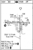
Question 1.) Why on the ILS 17RWY PNC is the NDB/LOM "PONCA" grayed out? My guess it is not used for the approach but I can not find a reference anywhere.
rhttp://204.108.4.16/d-tpp/1111/00603ILD17.PDF
Question 2.) What does the "HS1 or HS2" with a circle around intersection on airport diagrams mean in approach plates? e.g. MHK airport diagram
http://204.108.4.16/d-tpp/1111/05241AD.PDF
I guess my main question for both is where can I find reference stating these answers?
Thanks
Christopher