TMetzinger
Final Approach
Crossposted from the DC Pilots mailing list:
Good day, everyone:
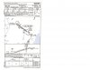
Now, I think the gray arrow is to identify COLBE, but don't know why the holding pattern is identified on the profile view.
Good day, everyone:
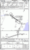
I was just studying the ILS 32 approach plate for Salisbury, which I have flown many times.
http://download.aopa.org/ustprocs/20090115/NE-3/sby_ils_or_loc_rwy_32.pdf
I can only find one IAF on the plate - the Snow Hill VOR. However, there is a "holding pattern" at COLBE depicted on the elevation diagram and a grey arrow from the SBY VOR (2000 to COLBE 140 degrees) which looks like a feeder to COLBE. (The missed is a hold at COLBE).
The transition from Snow Hill is labelled "NO PT". Should COLBE be an IAF?
If not, what is the purpose of the grey arrow pointing to COLBE from SBY and the holding pattern on the elevation view ?
Mark
Now, I think the gray arrow is to identify COLBE, but don't know why the holding pattern is identified on the profile view.
Last edited: