You are using an out of date browser. It may not display this or other websites correctly.
You should upgrade or use an alternative browser.
You should upgrade or use an alternative browser.
Anywhere map makes it to IPAD
- Thread starter sdflyer
- Start date
CT4ME
Cleared for Takeoff
and not to forget... ANDROID TABLETS!
Tim
Tim
EppyGA
Touchdown! Greaser!
No free trial period that I could see.
Meanee
Line Up and Wait
Awesome! Good to see more Android aviation apps! Maybe soon I can get rid of my iPad, all I use it for is ForeFlight and CouldAhoy
poadeleted21
Touchdown! Greaser!
- Joined
- Aug 18, 2011
- Messages
- 12,332
per the very few reviews so far, it looks like true to CV form they are going to let the first few years worth of paying customers frustrate themselves through the bugs. Then, they'll add tons of bloat without solidifying their base software.
kyleb
Final Approach
- Joined
- Jun 13, 2008
- Messages
- 7,554
- Location
- Marietta, GA
- Display Name
Display name:
Drake the Outlaw
per the very few reviews so far, it looks like true to CV form they are going to let the first few years worth of paying customers frustrate themselves through the bugs. Then, they'll add tons of bloat without solidifying their base software.
So, here's the question: With several iPad aviation app's already in the market, what does AWM bring to the party that is better than what's already out there?
poadeleted21
Touchdown! Greaser!
- Joined
- Aug 18, 2011
- Messages
- 12,332
So, here's the question: With several iPad aviation app's already in the market, what does AWM bring to the party that is better than what's already out there?
Only things I can think of is track up, their TAWAS or whatever they call it terrain shading is nice (when it works) and they do have "their map" that I find superior to sectionals. IMHO the sectional form factor does not translate well to handheld devices, it works better on an iPad size, but it's tits on a bull on iPhone sized devices.
I think one, maybe 2 others have track up. Anywhere map would be FINE software if it weren't so buggy and they could do a better job of hiding all the bloat that 99.99% of people will never even bother to tinker with.
Last edited:
iflyforfun
Pre-takeoff checklist
Only things I can think of is track up, their TAWAS or whatever they call it terrain shading is nice (when it works) and they do have "their map" that I find superior to sectionals. IMHO the sectional form factor does not translate well to handheld devices, it works better on an iPad size, but it's tits on a bull on iPhone sized devices.
I think one, maybe 2 others have track up. Anywhere map would be FINE software if it weren't so buggy and they could do a better job of hiding all the bloat that 99.99% of people will never even bother to tinker with.
Funny to read this ... nothing has changed since 2004 or so when I had AWM on an iPaq. Loved it when it worked. Spent more time trying to get it to work than I did flying with it. Learned to NEVER trust it since it would go tango uniform regularly and randomly. What, 8 years ago and it's the same thing ... always new features but never fixing the bugs.
AWM is like building a kitplane ... you doing it for the love of working on it, not because you actually want to fly with it. Use that approach and you love it and never be bored :wink2:
CT4ME
Cleared for Takeoff
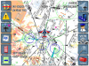
'always loved AWM's "cones of safety", or whatever they called them... a circle showing your glide range.
kimberlyanne546
Final Approach
'always loved AWM's "cones of safety", or whatever they called them... a circle showing your glide range.
That sounds awesome. I wonder if foreflight could add that. Was it different for each type of plane?
poadeleted21
Touchdown! Greaser!
- Joined
- Aug 18, 2011
- Messages
- 12,332
That sounds awesome. I wonder if foreflight could add that. Was it different for each type of plane?
You put in your numbers and it draws bigger circles as you gain altitude. They also have a virtual ILS which I thought would come in handy at my PAPI/VASIless airport, I never looked at it. I suppose it would come in handy if you were on the gauges and your ILS crapped out or something.
sdflyer
Pre-takeoff checklist
I suppose it would come in handy if you were on the gauges and your ILS crapped out or something.
I wouldn't rely on it that match
TangoWhiskey
Touchdown! Greaser!
Only things I can think of is track up, their TAWAS or whatever they call it terrain shading is nice (when it works) and they do have "their map" that I find superior to sectionals. IMHO the sectional form factor does not translate well to handheld devices, it works better on an iPad size, but it's tits on a bull on iPhone sized devices.
I think one, maybe 2 others have track up. Anywhere map would be FINE software if it weren't so buggy and they could do a better job of hiding all the bloat that 99.99% of people will never even bother to tinker with.
Track up is something AwM does, but... view their screenshots on the Apps download page. They literally rotate the rasterized images. I think it would be hard to read some frequencies or data when they are upside down or slanted like that. (And I'm a "track up" guy, so I like things depicted that way). Vector-drawn graphics / maps don't have that limitation.
Attachments
Challenged
Pattern Altitude
I enjoy trying out the various aviation-related applications for my Transformer, Android tablet, so I went ahead and purchased this. I didn't have any experience with the Anywhere Map products previously, but I'm enjoying the interface and the presentation of the information so far.
The "Cones of Safety" and simulated IFR approach system are both novel, but actually presented in such a way that they can be used as a quick cross-reference, so I think they're useful in that sense. I flew for 0.8 yesterday in order to mess around with the application a bit while in flight and I enjoyed it. The terrain warning system and obstacle avoidance are both handy. Sometimes I don't always immediately update my Garmin with the latest databases, since it's sort of a pain to unhook things and take it home, so having this as an always-updated backup works well for my own piece of mind.
Really, the main reason I bought the app is that they have said that it will support both XM and ADS-B by the time AirVenture opens in July, so I'm excited about that, and consequently the price of the app itself will then increase. The XM options are already included inside of the application settings, but they don't do anything just yet. I do already have XM weather on my 496, which works well, but I'm very interested in ADS-B options, with the hope that I can get both weather and reliable traffic information at some point down the road.
There are actually a good number of options that, while shown, aren't yet enabled (from the Anywhere Map site): "Features yet to be added include the full HSI, some reminders, regional database downloads. Fully integrated Approach plates, victor airways routing wizard and the flight calculator."
Last edited:
JGoodish
Cleared for Takeoff
- Joined
- Jun 10, 2006
- Messages
- 1,419
- Display Name
Display name:
JGoodish
Really, the main reason I bought the app is that they have said that it will support both XM and ADS-B by the time AirVenture opens in July, so I'm excited about that, and consequently the price of the app itself will then increase. The XM options are already included inside of the application settings, but they don't do anything just yet.
There are actually a good number of options that, while shown, aren't yet enabled (from the Anywhere Map site): "Features yet to be added include the full HSI, some reminders, regional database downloads. Fully integrated Approach plates, victor airways routing wizard and the flight calculator."
AnywhereMap sells the "sizzle" perhaps better than anyone else in the aviation hand held market. The problem is, the steak that they deliver to you is full of disease. When you complain, they'll come back to your table and cut out some of the bad meat, and then eventually they'll just bring you an even bigger diseased steak on a nicer plate with better garnish (and maybe a glass of champagne!) But they never get the quality of the steak to match the promise of the sizzle.
When I bought an iPaq-based AWM system (with XM WX) a few years ago, Control Vision was sweet as pie during their 30 day return period. They worked with me to address the bugs and basically bent over backwards to make sure that I was happy. I used the system as supplemental navigation/weather on a trip from PA to CO and back, and it was definitely helpful, even though the iPaq crapped out a few times (due to heat), and their software crashed a couple of times. But for the most part, it was workable.
Then, I began to discover that their navigation and airport data was full of errors--incorrect runways, frequencies, etc. Obstacles that were on top of hills didn't alarm due to the midwest plains-based thresholds that they had set in the software. Although not necessarily Control Vision's fault, the XM WX antenna was incredibly sensitive to placement, and would often lose signal. I didn't realize how lacking the product was until Garmin launched the 396 and I bought one. On the Garmin, everything just worked, and continues to work to this day without a hiccup.
When I approached Control Vision with issues after the 30 day return period, they were NOTICEABLY less interested in my satisfaction. I eventually wrote an e-mail to the company's president, Jay, expressing my disappointment, and his response was basically that I'm stuck with the product and I'm going to have to wait until IF and when they decide to address any of the outstanding issues. At that time at least, CV used new features to drive sales, and wasn't as focused on fixing prior problems and producing a high-quality, stable application.
Historically, it is my perception that Control Vision has been hostile to development on Apple's platform, probably because they can't source the hardware cheaply and bundle it into a high-margin solution. I'm not sure what development tool they're using for the multi-platform support, but I am skeptical that the program will be as nicely done as ForeFlight, for example, and to a certain extent Control Vision will be at the mercy of the development tools for feature support and stability on specific platforms. I haven't heard whether the program takes advantage of the new high resolution display on the iPad 3, but I'm not holding my breath.
With all of that said, AWM is likely better than ForeFlight as a hand held GPS replacement. I would probably be more likely to take AWM over WingX, based on my observations during the trial period with WingX. However, since I have a Garmin in the plane, I am more interested in plate, chart, and airport data than in navigation, and in those areas, ForeFlight excels over the others that I've used.
JKG