Anybody know of a good online aviation radius map?

Aha, I had to put *.* in the Explorer filename field to make it show TIFFs. Thanks!

Thanks for the contributions to the thread, everyone!
 
Google Earth.
Ugh. Nerd sniped :( I just spent way too much time getting sectionals into earth.google.com.

I went to

https://tiles.arcgis.com/tiles/ssFJjBXIUyZDrSYZ/arcgis/rest/services/VFR_Sectional/MapServer [1]

, lifted out one of the tile URLs, and turned it into the kind of template it was looking for:


overlayurl.png

I was also able to pull some metadata out of this xml:


in order to set the bounding box:

boundingbox.png
It worked!
googleearth.png
Center your home airport. Click on the Ruler. Click on Circle. Click on your home airport and drag out to the radius you want. In the search box, enter "Airports".

Unfortunately, the web version does not seem to support the Circle tool, but I bet you could follow the above process to load the charts into the native version of Google Earth.

[1] https://www.pilotsofamerica.com/com...-happened-to-chartbundle.145754/#post-3487938
 
If considering older option (mentioned in 2017, post #2), Avnwx.com illustration:
- not on sectional; tap on airport to display identifier
- circle increments: 10,25,50,100,150,250,500
 

Attachments

  • AF869F3F-3F1E-4894-8366-AF9F78F2DC5C.jpeg
    AF869F3F-3F1E-4894-8366-AF9F78F2DC5C.jpeg
    1.5 MB · Views: 6
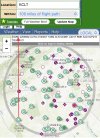
Here's a screen shot of 2 concentric circles at 50NM and 100NM around KPHL using skyvector.

View attachment 74228


I'll even be nice and provide the waypoints used for the first circle:
KPHL360050
KPHL010050
KPHL020050
KPHL030050
KPHL040050
KPHL050050
KPHL060050
KPHL070050
KPHL080050
KPHL090050
KPHL100050
KPHL110050
KPHL120050
KPHL130050
KPHL140050
KPHL150050
KPHL160050
KPHL170050
KPHL180050
KPHL190050
KPHL200050
KPHL210050
KPHL220050
KPHL230050
KPHL240050
KPHL250050
KPHL260050
KPHL270050
KPHL280050
KPHL290050
KPHL300050
KPHL310050
KPHL320050
KPHL330050
KPHL340050
KPHL350050
KPHL360050


Modify your way point and distance to your hearts content.
This method worked perfectly in ForeFlight on the web. Copy and paste the above way points into MS Word, then Find/Replace (Ctrl+F) "PHL" with identifier of starting point, select replace all, then copy and paste into ForeFlight FPL route, and load the Sectional view. Took me all of about 45 seconds to do that, and most of that was waiting for Word to load. Easy to do the same for distance, just Find/Replace "050" with distance desired.

Thanks apr911 for doing the hard work for that, very helpful. Finally have a way to do this simply. Now I just hope others that were/are looking for this same thing are able to find it easily enough.

As a side note, the AOPA flight planner did not like this format. Unknown on other applications as I do not have any.
 
NACO used to produce a two panel VFR/IFR wall planning chart. I had it hanging in my office for a while. I had a string that hand marks on it every 100 miles dangling from a thumbtack. It's too bad they stopped making that particular one. Later when I got a different office and had more wall space, I replaced it with three panels of the DMA JNC charts instead.

One airport I stopped at had a cute thing. THey had mosaicked a bunch of sectionals together on the wall and then ran a string through an eyelet where the airport was and that ran over to a pulley and a weight. As you pulled the end of the string out from the airport, the weight ascended a printed scale on the wall that told you how far you had gone.
 
Back
Top