

TangoWhiskey
Touchdown! Greaser!
- Joined
- Feb 23, 2005
- Messages
- 14,210
- Location
- Midlothian, TX
- Display Name
- 3Green
- Home Airfield
- KJWY - Mid-Way Regional
Take this plate for the SEAVU TWO arrival into KLAX:
http://204.108.4.16/d-tpp/0910/00237SEAVU.PDF
Altitudes, distances and direction are noted between fixes like they are on feeder routes to an IAF. But are the altitudes noted in this manner on a STAR altitudes "to be flown", or MEAs like on an enroute chart?
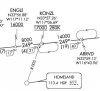
Between KONZL and ENGLI, the plate notes 8000' for 4nm on a heading of 249. But the callout for KONZL has notations specifying EXACTLY 17000' and 280 knots, and the ENGLI callout is for above 16000'.


 And IIRC you're expected to be doing that regardless of whether they give you a "descend via" clearance or not!


