robertb
Pre-Flight
Hello all,
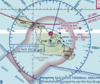
I recently flew into Catalina Island's airport and ended up with an airspace question. I "think" the class E airspace over most of the island begins at 700' agl. As the terrain/ocean surface varies significantly within the magenta shape, is there a consistent floor to the class E throughout the airspace (700' above highest terrain?) or does it change as you are flying over various parts of the island and ocean (2,237'msl over the SXC VOR, 2,302' msl over the aiport, and 700' msl over the nearby ocean, ect)?
This question stems from a situation where "1 mile and clear of clouds" is all it takes to get to the runway. I understand the Class G airspace exists under the Class E shape. But, if you are on a one mile final to runway 22 (over the ocean at that point) at 1,700' msl and the ceiling is 1,800' msl, are you legal to be flying VFR? Are you in Class E or G at that point?
The reason I ask is because I was IFR to the island recently and was on a visual approach to runway 4. I took a visual because I would not have been able to get into the airport on either of the IAPs due to the unique cloud situation. Someone else called in on a 4 mile final to runway 22 at 1,000'. There was a layer to the east of airport with bases reported at 1,200' msl and tops at 1,900' msl. It was a helicopter but I have seen fixed wing planes magically pop up over cliff just before the threshold out from under a cloud layer.