Please decipher for me then -
I'm still a student pilot - still learning why it seems better to speak in unclear language in a field that needs razor sharp precision -
So let's take it part by part
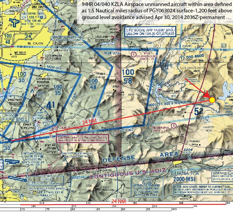
"!HHR 04/040" - What does this mean?
"KZLA Airspace unmanned aircraft" - How about this? Are they defining a new airspace? What is KZLA? Obviously there is an unmanned aircraft, but are they saying it is in a specific airspace? What airspace? Who is manning the unmanned aircraft?
I guess the rest is trying to say where it is. That I understand.
"!HHR 04/040" - What does this mean? -- To be honest, I don't know. I would guess that HHR airport is either who generated the NOTAM or who is seen as being affected by the NOTAM.
KZLA Airspace unmanned aircraft" -- Los Angeles Airspace, meaning users in and around LA airspace need to be aware.
I guess the rest is trying to say where it is. That I understand. -- That is that part that matters. Plot it, and avoid it. If you can't avoid it for some strange reason, start making some phone calls and asking questions. I would start with HHR airport, see what they know, then call LA ARTCC.
There are things in NOTAMs that don't make sense to me sometimes, but I don't worry about it unless it will impact my flight in some way. The ones that are pertinent that I don't understand, I start searching and asking questions until I get a good answer. If you find an answer to the !, I'd be curious to know. I haven't seen that.
BTW, I downloaded FAA Contractions, and FAA Pilot/Controller Glossary into my ForeFlight Documents. It has come in handy a few times.