Airspace charting question

Joshuajayg

Line Up and Wait
Joined
Sep 1, 2015
Messages
907
Location
'Merica
Display Name

Display name:
Joshua
So, here's a little piece airspace that doesn't make sense to me.


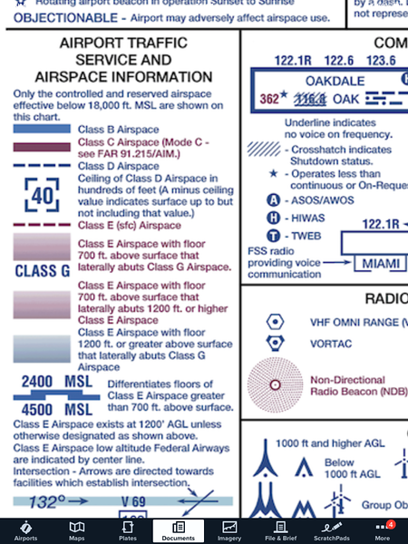
Inside the blue shaded lines should be Class E from 1200' feet that laterally abuts Class G. So that means Class G up to... 14,500. Yet the magenta shaded lines near it don't say "Class G" on the outside. So, did the chart makers put the blue shaded line inside out? Should the hard edge be on the inside of the triangle? The IFR low chart shows that triangle as G up to 14,500.

Joshua
 
It's correct. That small area represents airspace up to 14,500. Functionally you can ignore it. I'm not sure why we haven't found a way to systematically do away with the small slivers of class G up to 14.5 yet that still litter the charts, and has no real use (unless perhaps you're a skydiving operator).
 
It's correct. That small area represents airspace up to 14,500. Functionally you can ignore it. I'm not sure why we haven't found a way to systematically do away with the small slivers of class G up to 14.5 yet that still litter the charts, and has no real use (unless perhaps you're a skydiving operator).

Indeed, it is correct. You have me wondering though, what advantage would the class G airspace be to skydive operators? I haven't read the regs on that in a while but it doesn't seem like there would be a whole lot of advantage to them?
 
Indeed, it is correct. You have me wondering though, what advantage would the class G airspace be to skydive operators? I haven't read the regs on that in a while but it doesn't seem like there would be a whole lot of advantage to them?

lower visibility requirements (1sm vs 3 )under 10k MSL...and the fact that they essentially operate vertically, so they might actually be able to use that small carve-out of class G airspace. Otherwise, not much.
 
lower visibility requirements (1sm vs 3 )under 10k MSL...and the fact that they essentially operate vertically, so they might actually be able to use that small carve-out of class G airspace. Otherwise, not much.

Looking in part 105, it appears that there is no discrimination between airspaces and visibility requirements. Obviously the jump planes could operate with lower visibility though.
 
Looking in part 105, it appears that there is no discrimination between airspaces and visibility requirements. Obviously the jump planes could operate with lower visibility though.

We're talking about the plane, not the jumpers. The planes circle up to altitude, and corkscrew back down for the next load. Not quite as vertical as the jumpers, but close!
 
We're talking about the plane, not the jumpers. The planes circle up to altitude, and corkscrew back down for the next load. Not quite as vertical as the jumpers, but close!

I know, I've flown them. My point is, the weather minimums and restrictions are higher for the jumpers than they are for a plane in class G, so you wouldn't likely be taking them up in those conditions anyway. :)

EDIT - That's not to say it wouldn't be legal to make the flight, you just couldn't legally let the jumpers get out unless the weather was better wherever they're getting out.
 
The shading is backwards. The hardline should be to the inside.

Yep, looking at it again I concur. Can I change my original answer?

To verify, look at the shaded areas around ABR on http://vfrmap.com/ for comparison. I still don't know why we bother to chart those small chunks.
 
Parachute operations cloud clearances are basically Class E minimums. I guess the only difference in dropping people within that triangle would be that you don't have to talk to any controlling agency. But that isn't really a good idea either.
 
I wonder if it is one of the leftover Class Gs after surrounding area gets lowered to Class E.
I have seen a few weirdly-shaped Gs like this one in the past, just to find out that they are formed by carving E-corridors through originally G airspace.
A historical progression of revisions of this charted area would tell us more.

That is most likely the case because you can see it borders a Victor Airway on the southeast and as more approaches got added to the local airports, the 1200' Class E got expanded to suite those airports. There is another sliver north of that position that isn't depicted on a VFR sectional but IS depicted on the IFR low chart.
 
I wonder if it is one of the leftover Class Gs after surrounding area gets lowered to Class E.
I have seen a few weirdly-shaped Gs like this one in the past, just to find out that they are formed by carving E-corridors through originally G airspace.
A historical progression of revisions of this charted area would tell us more.

It is. It just doesn't make sense to bother charting it, really.
 
Is it covered by ATC radar? The slivers of G here in North Dakota have nice curved edges that you can follow to the focal point, generally a city where you'd expect to see ATC radar. Probably the airways were flight tested for radar coverage but any off-airway areas weren't tested and thus class E got limited to some distance from the nearest radar with the rest left as class G. I doubt that any of these slivers were created for a purpose rather than as a consequence of some system limitation.

And yes, that one near AJZ does look to be inside-out.
 
On another charting note, I was checking out Garmin Pilot's vector based maps since Foreflight wants an extra $50 for theirs when it comes out in a week or so. None of these slivers are shown on Garmin's map. And neither are wilderness areas where you should be 2000 feet agl. I wonder if Foreflight's vector maps will show these things.
 
Yep, looking at it again I concur. Can I change my original answer?

To verify, look at the shaded areas around ABR on http://vfrmap.com/ for comparison. I still don't know why we bother to chart those small chunks.

Some of them are so small it really doesnt make much sense. There obviously isn't some "rule" that says if a piece of G is "this small, don't bother charting it. If you look at it not from a "charting G" standpoint, but instead as what's left over after "charting A, B, C, D and E" it makes some sense, kinda. A, B, C, D are very specific, the lines are right there in blue and magenta, some solid, some dashed. E is a little more vague. The blue 1200 agl stuff is for the most part associated with airways and is basically 4 miles either side of the airway center line. The 700 agl stuff is basically associated with airports and protecting IFR aircraft flying into and out of them. G is just what's left over.
 
Yep, looking at it again I concur. Can I change my original answer?

To verify, look at the shaded areas around ABR on http://vfrmap.com/ for comparison. I still don't know why we bother to chart those small chunks.
The charting folks follow the legal description of airspace.
 
Is it covered by ATC radar? The slivers of G here in North Dakota have nice curved edges that you can follow to the focal point, generally a city where you'd expect to see ATC radar. Probably the airways were flight tested for radar coverage but any off-airway areas weren't tested and thus class E got limited to some distance from the nearest radar with the rest left as class G. I doubt that any of these slivers were created for a purpose rather than as a consequence of some system limitation.

And yes, that one near AJZ does look to be inside-out.

Hmm. Yeah. At first it looks like there are "arcs" of 1200 foot blue stuff centering on Bismarck, but then there are some other "arcs" that seem centered on somewhere close to Bismarck but farther away. The one that stands out is that piece of G about 20 miles northeast of DPR. It doesn't follow the same "focal point" as the other "arcs" around that area. It's got me scratchin my head.
 
I wonder if it is one of the leftover Class Gs after surrounding area gets lowered to Class E.
I have seen a few weirdly-shaped Gs like this one in the past, just to find out that they are formed by carving E-corridors through originally G airspace.
A historical progression of revisions of this charted area would tell us more.

Yeah. Knowing the "history" can explain many things that don't seem to make sense. And there are a lot of them. The continuing saga of DP's, alphabet soup airspace, Approach charts and STARS in the GPS era and why so many of them are "different" and the answer is that some of them off the beaten path haven't been updated to the latest plan concocted by the "committees" that drive the system.
 
Some of them are so small it really doesnt make much sense. There obviously isn't some "rule" that says if a piece of G is "this small, don't bother charting it. If you look at it not from a "charting G" standpoint, but instead as what's left over after "charting A, B, C, D and E" it makes some sense, kinda. A, B, C, D are very specific, the lines are right there in blue and magenta, some solid, some dashed. E is a little more vague. The blue 1200 agl stuff is for the most part associated with airways and is basically 4 miles either side of the airway center line. The 700 agl stuff is basically associated with airports and protecting IFR aircraft flying into and out of them. G is just what's left over.
The charting folks follow the legal description of airspace.

Yup. And I suggest that while the airspace would still exist, the FAA charting folks would just need to enact an internal policy to omit depicting the small chunks for convenience and readability sake.
 
Yup. And I suggest that while the airspace would still exist, the FAA charting folks would just need to enact an internal policy to omit depicting the small chunks for convenience and readability sake.

I second the motion. The policy should probably come from a little higher than the "charting folks" though
 
Last edited:
I'd rather see the airspace eliminated and the charts complete and accurate. Airspace is regulatory and any requirement that we look outside of the charts to know where it is would be a bad thing. These pockets of G are small and unlikely to see anyone taking advantage of the lower minimums than exist in the surrounding E airspace, but if they exist they should be on the chart. And they should be charted right-side-out. :)
 
These little slivers of Class G prove to be often just oversight and "not-my-job" mentality by the governing agencies/committees.
They use them new-age digital computers to expand Class E somewhere along Victor airways which leaves just a tiny piece of Class G but then they don't know how to tell the computer to include also the silly leftover blue piece. And with that, their job is done. They don't bother with the rest.

Or did I get the governing agency's internal workings wrong? :D
 
If they turned those slivers of Class G into Class E there would be someone out there complaining of an airspace grab.
 
These little slivers of Class G prove to be often just oversight and "not-my-job" mentality by the governing agencies/committees.
They use them new-age digital computers to expand Class E somewhere along Victor airways which leaves just a tiny piece of Class G but then they don't know how to tell the computer to include also the silly leftover blue piece. And with that, their job is done. They don't bother with the rest.

Or did I get the governing agency's internal workings wrong? :D
If they turned those slivers of Class G into Class E there would be someone out there complaining of an airspace grab.
In a class I took, an airspace guy explained that the airspace belongs to the people unless there is good reason to place restrictions on it, such as A, B, C, D, E airspace; restricted areas; etc. If it doesn't meet the standard for Class E, then you can't just make it so.
 
Those old large G airspaces up to 14.5k were there because there wasn't radar coverage. They have better radar and more of it now, so they have mostly gone away.
 
If they turned those slivers of Class G into Class E there would be someone out there complaining of an airspace grab.

As I proposed, they would not change the designation of the airspace; they would just not depict the small slivers of airspace that have no practical purpose.
 
As I proposed, they would not change the designation of the airspace; they would just not depict the small slivers of airspace that have no practical purpose.
If they were not depicted there would probably be even more complaints when someone figured it out.
 
What would they complain about?
Inaccurate charting.

I'm not saying that I like seeing those slivers or airspace or that they have any practical use, but airspace and charting adhere to certain standards, and there will be people complaining of an airspace grab or saying that the charts are not accurate.
 
Inaccurate charting.

I'm not saying that I like seeing those slivers or airspace or that they have any practical use, but airspace and charting adhere to certain standards, and there will be people complaining of an airspace grab or saying that the charts are not accurate.

People will complain about anything. But what would their legitimate complaint be? 1) its not a airspace grab because it's not a change in airspace 2) There is no harm to NAS users by omitting those small parcels.

What is the principal reason the blue shaded airspace is charted? To show airspace users where they cannot get air traffic control services. These areas are so small there is no significant value to knowing about them.

And by the way, converting airspace from G to E, while it requires rule making like any other airspace re-designation, is generally not considered an "airspace grab" because there is no operational loss of use compared to class G airspace. In the contrary, there is benefit by having the ability to utilize ATC services.

As far as inaccuracies, all maps have inaccuracies to some extent, due to the nature of map making. Cartographers often make decisions on how to depict certain things, omit certain things, etc. to enhance readability. I think this would be one of them.
 
As far as inaccuracies, all maps have inaccuracies to some extent, due to the nature of map making. Cartographers often make decisions on how to depict certain things, omit certain things, etc. to enhance readability. I think this would be one of them.
I don't think that sliver shown above makes the chart any less readable. It's supposed to be accurate, not a work of art.
 
Those old large G airspaces up to 14.5k were there because there wasn't radar coverage. They have better radar and more of it now, so they have mostly gone away.

I don't think Radar is so much the factor as RNAV is. There are many places where Air Traffic Control is excercised, and therefore "controlled airspace" that are not in Radar coverage. There is still at least one "Non Radar Approach Control" in the US. The ability to communicate is a primary requirement for airspace to be "controlled," and the ability to navigate. GPS really changed the equation. Pilots could now navigate just about anywhere. Many started flying IFR through "uncontrolled airspace. ATC couldn't deny it. It caused confusions and problems. What I have heard, and it sure passes the logic check, that GPS was the main force behind the G airspace "grabs." I'm pretty sure that preparing for ADSB is fueling it also.
 
I second the motion. The policy should probably come from a little higher than the "charting folks" though
.. And hence, the reason it does not get changed. The people who know of the problem don't have the power to make the change, and the people with the power can't be bothered. And it's not important enough for the lower level people to start the fight required to get the change made.
 
Those old large G airspaces up to 14.5k were there because there wasn't radar coverage. They have better radar and more of it now, so they have mostly gone away.

Controlled airspace does not require radar and radar alone does not enable the provision of ATC services.

IMNSHO, remaining areas of Class G airspace where real-time surveillance and direct pilot-controller communications exist should be made Class E.
 
As I proposed, they would not change the designation of the airspace; they would just not depict the small slivers of airspace that have no practical purpose.

Class E airspace exists at 1200' AGL unless otherwise designated. You propose removing that which indicates the otherwise designation, which effectively changes the designation.

For VFR operations in these areas the only difference is the daytime visibility minimum below 10,000 MSL; one mile in Class G airspace vs. three miles in Class E. I think removing the chart clutter has more benefit than retaining these small areas as Class G.
 
So it's not radar coverage per se. It is also ability to have radio comms. Any other parameters? The space must be able to be included in ATC ifr control.

The two areas I knew of were in northern Arizona and the Michigan pennisula and they are Class E now. I suppose there are some in Alaska still. I flew them both, but not in the clouds... Nice to have semi wilderness areas like that....
 
So it's not radar coverage per se. It is also ability to have radio comms. Any other parameters? The space must be able to be included in ATC ifr control.

Communications, NAVAIDs, and a means of surveillance are the tools required to provide ATC services. Before radar, surveillance was provided by combined use of NAVAIDs and radio communications through position reports, and the radio communications did not have to be direct pilot/controller. Today, services can be provided without use of traditional NAVAIDs but real-time surveillance requires direct communications.
 
Back
Top