DCat22
Filing Flight Plan
Got my first aerial geohash last night! (Well, almost...)
Now, those that read XKCD are probably laughing at me...for everyone else, a brief explanation is in order: Imagine, a $100 hamburger trip, except to a specific set of lat/long coordinates. And that those coordinates are based on an algorithm that uses the previous close of the Dow as its source for a random seed.
Still with me?
The points repeat, as the output of the algorithm is just the minutes and seconds -- so there is a repeating point in every 1x1 degree lat/long grid (called a graticule).
Here is the source of all this: http://xkcd.com/426/
(XKCD the source of people playing chess on rollercoasters, the bottom of pools...and guitar in the shower...and one of my favorite webcomics.)
The basic premise is go to that point. ...and the "official" time where you may run into other geohashers is 4PM on Saturdays. (You just need a picture of you and your GPS. Not many people active around Houston though...)
The site which has all the detail, trip reports, etc, is here: http://wiki.xkcd.com/geohashing
And the mapping utility (click in the map to show the point for each graticule): http://irc.peeron.com/xkcd/map/
The first Air Geohash: http://wiki.xkcd.com/geohashing/2008-06-11_31_-84
And my post: http://wiki.xkcd.com/geohashing/2009-06-27_30_-95
(So far, seems there are only 2 other pilots that have gotten hashes. And not many of these "awards" have been claimed: http://wiki.xkcd.com/geohashing/Air_Geohash )
Laughing at me yet, now? Hey, there are worse reasons to spend money...")
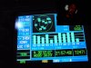
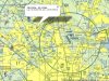
As for my actual trip, which was my second flight with a passenger (also a geek)...the hash point was in the southeast corner of the DWH delta, and pretty close to the Bravo. I was taking him on a quick "downtown" trip, so on the way back, got through the Bravo on FF...so the point was lined up with a downwind entry to Hooks. Difficulty with that is that both numbers were moving at the same time...ideally I would get one direction right, and fly a straight line until the other matched...as you can see, I didn't nail it exactly...and unfortunately the picture wasn't taken when I was within 10 seconds of the location, so it technically doesn't count...N30°01'09.33", W95°30'49.17" vs my N30°01'07", W95°30'23". (And, then got a fun scare with some deer crossing the runway, but that is another story.)
So...thoughts? (/hides under rock/)
[xposting to the red/purple/green...its a worthy cause!]
Now, those that read XKCD are probably laughing at me...for everyone else, a brief explanation is in order: Imagine, a $100 hamburger trip, except to a specific set of lat/long coordinates. And that those coordinates are based on an algorithm that uses the previous close of the Dow as its source for a random seed.
Still with me?
The points repeat, as the output of the algorithm is just the minutes and seconds -- so there is a repeating point in every 1x1 degree lat/long grid (called a graticule).
Here is the source of all this: http://xkcd.com/426/
(XKCD the source of people playing chess on rollercoasters, the bottom of pools...and guitar in the shower...and one of my favorite webcomics.)
The basic premise is go to that point. ...and the "official" time where you may run into other geohashers is 4PM on Saturdays. (You just need a picture of you and your GPS. Not many people active around Houston though...)
The site which has all the detail, trip reports, etc, is here: http://wiki.xkcd.com/geohashing
And the mapping utility (click in the map to show the point for each graticule): http://irc.peeron.com/xkcd/map/
The first Air Geohash: http://wiki.xkcd.com/geohashing/2008-06-11_31_-84
And my post: http://wiki.xkcd.com/geohashing/2009-06-27_30_-95
(So far, seems there are only 2 other pilots that have gotten hashes. And not many of these "awards" have been claimed: http://wiki.xkcd.com/geohashing/Air_Geohash )
Laughing at me yet, now? Hey, there are worse reasons to spend money...
As for my actual trip, which was my second flight with a passenger (also a geek)...the hash point was in the southeast corner of the DWH delta, and pretty close to the Bravo. I was taking him on a quick "downtown" trip, so on the way back, got through the Bravo on FF...so the point was lined up with a downwind entry to Hooks. Difficulty with that is that both numbers were moving at the same time...ideally I would get one direction right, and fly a straight line until the other matched...as you can see, I didn't nail it exactly...and unfortunately the picture wasn't taken when I was within 10 seconds of the location, so it technically doesn't count...N30°01'09.33", W95°30'49.17" vs my N30°01'07", W95°30'23". (And, then got a fun scare with some deer crossing the runway, but that is another story.)
So...thoughts? (/hides under rock/)
[xposting to the red/purple/green...its a worthy cause!
]Attachments
Last edited:


