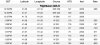
Equipping with ADS-B out will provide a similar benefit. That's because of privately owned networks of ground-based receivers. FlightAware now has almost complete coverage of 48 states. Typing in the tail number of my out-equipped plane, FlightAware shows records of my gps positions, at intervals of a minute or two.
The biggest downside of using that for search and rescue might be altitude -- the FlightAware receivers don't record me below about 1000' agl. But otherwise it generates a real time archived record of gps positions, similar to what you might have in mind.
Here are a few minutes toward the end of my last flight, stopping at about 1600 msl as I descended to an airport at 600'. Plotting those records anyone could see that I was descending from the FAF of an approach to RWY 25 at KIOW. If I crashed, it wouldn't tell you where I came to a stop, but it would give a pretty good hint.
View attachment 41234