Lawreston
En-Route
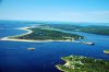
In August of 2009 I took Photo 1 which is below. June 28, 2014, heading back to KIWI after an extensive aerial photo shoot, I had just a few shots left on my Flash Card and took the 2nd shot shown here. Only after I had downloaded the new shoot did it occur to me that part of the new image is very similar to the old shot. Bay Point, Georgetown, is several miles below my house. The 2nd shot points at historic Popham Colony, Popham Beach, Popham State Park(beyond the Beach) and further south. At the Fort is where the Kennebec River flows into the ocean, and where the new Navy ships from Bath Iron Works first meet the deep water.
HR
HR