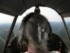
Photos from the 2010 grass strip tour

Diana

Final Approach
Joined
Feb 21, 2005
Messages
6,163
Location
Southwest MO
Display Name

Display name:
Diana
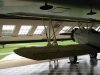
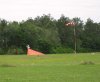
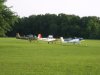
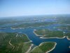
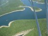
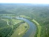
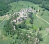
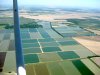
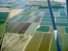
Gosh, there is sooooooo much to say about this trip. :yes: But, until I gather my thoughts, here are some assorted photos. I'm going to put a bunch more on my Facebook page later.

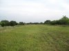
There were several more interesting grass strips that I was hoping to fly to, but the weather was looking iffy for flying home. Good thing I left Texas when I did. I wouldn't have been able to fly home even now.

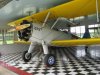
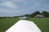
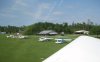
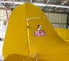
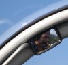
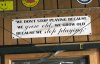
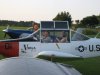
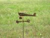
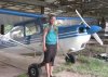
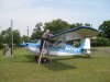
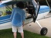
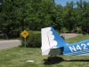
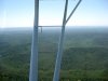
The first photo is from my first stop at Gaston's. The "SLOW bird XING" sign seemed so appropriate, as I had a ground speed of only 65 KTS in my slow bird, flying down to Gaston's.

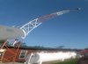
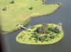
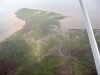
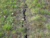
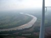
The last photo was taken somewhere between Gaston's and Helena, AR. I just happened to look down and see those interesting rocks. Anyone know anything about them?

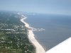
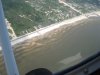
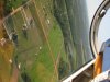
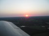
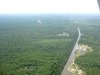
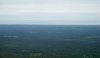
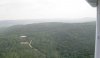
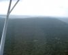
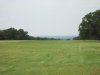
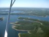
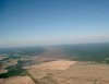
It sure is fun to see our beautiful country low and slow. :yes:
 

Attachments

  • Bull Shoals Lake 2 e (1077 x 808).jpg
    Bull Shoals Lake 2 e (1077 x 808).jpg
    147.4 KB · Views: 47
  • Slow bird crossing e (673 x 515).jpg
    Slow bird crossing e (673 x 515).jpg
    141 KB · Views: 54
  • Bull Shoals Lake 4 e (1077 x 808).jpg
    Bull Shoals Lake 4 e (1077 x 808).jpg
    175.2 KB · Views: 41
  • Bull Shoals Lake 3 e (816 x 612).jpg
    Bull Shoals Lake 3 e (816 x 612).jpg
    137.9 KB · Views: 44
  • Winding White River e (1077 x 808).jpg
    Winding White River e (1077 x 808).jpg
    228.5 KB · Views: 45
  • Rock formations e (1350 x 1220).jpg
    Rock formations e (1350 x 1220).jpg
    521.9 KB · Views: 58
  • Arkansas mountains e (1632 x 1224).jpg
    Arkansas mountains e (1632 x 1224).jpg
    345.4 KB · Views: 38
These different colored rectangles were interesting. Didn't know what they were until Steve told me.

The third photo was taken as I flew along on the way to Steve's. It was just outside of Yazoo City. You can see the wide brown swath that the tornado made as it went through town.

I already posted photos of Steve in the other thread. They are all flattering. ;) :D
 

Attachments

  • Catfish farms 2 e (1632 x 1224).jpg
    Catfish farms 2 e (1632 x 1224).jpg
    401.6 KB · Views: 46
  • Catfish farms  1 e (1632 x 1224).jpg
    Catfish farms 1 e (1632 x 1224).jpg
    451.4 KB · Views: 42
  • Tornado path at Yazoo City e (2151 x 1664).jpg
    Tornado path at Yazoo City e (2151 x 1664).jpg
    523.1 KB · Views: 53
Cool, Diana!
Thanks for sharing your trip with us!
Do you have a route map?
 
There are lots of photos of Shade Tree Airfield to post. Here are some of my favorites. I got a ride in the Stearman as soon as I landed. :goofy: 
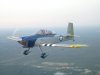
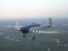
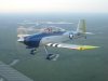
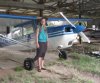
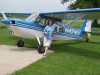
Danny flies it well. Janet's airplane is fun, too. :yes: I'd never seen a Varga Kachina before.
 

Attachments

  • Stearman e (1077 x 808).jpg
    Stearman e (1077 x 808).jpg
    203.6 KB · Views: 37
  • Stearman 2 e (1632 x 1224).jpg
    Stearman 2 e (1632 x 1224).jpg
    354.9 KB · Views: 36
  • Bent beacon tower e (2224 x 1640).jpg
    Bent beacon tower e (2224 x 1640).jpg
    430.3 KB · Views: 41
  • Kenny Mac and snake 2 e (549 x 808).jpg
    Kenny Mac and snake 2 e (549 x 808).jpg
    136.9 KB · Views: 40
  • Dan's Starduster e (1077 x 808).jpg
    Dan's Starduster e (1077 x 808).jpg
    169.9 KB · Views: 35
  • Danny fueling the Citabria e (816 x 612).jpg
    Danny fueling the Citabria e (816 x 612).jpg
    88.6 KB · Views: 39
  • Varga Girl e (1632 x 1224).jpg
    Varga Girl e (1632 x 1224).jpg
    392.4 KB · Views: 36
  • Janet and her Varga e (1632 x 1224).jpg
    Janet and her Varga e (1632 x 1224).jpg
    462.1 KB · Views: 42
Cool, Diana!
Thanks for sharing your trip with us!
Do you have a route map?

Thanks, Mari and Dave. :)

Good idea about the map, Dave. As soon as I post all the rest of the photos, I'll make one on my Flitesoft program and post it. :)
 
Janet flew with me in the Citabria and then I flew with her in her Varga. She's really a very neat lady...I loved spending time with her. Well, I loved spending time with EVERYONE there. :yes: What a wonderful little airport!
 

Attachments

  • Island with a bridge e (1368 x 1008).jpg
    Island with a bridge e (1368 x 1008).jpg
    320.2 KB · Views: 31
  • Gulfport e (1077 x 808).jpg
    Gulfport e (1077 x 808).jpg
    142.5 KB · Views: 27
  • Flying with Janet e (816 x 612).jpg
    Flying with Janet e (816 x 612).jpg
    110.7 KB · Views: 45
  • Janet flying the Varga e (1632 x 1224).jpg
    Janet flying the Varga e (1632 x 1224).jpg
    355.8 KB · Views: 40
  • Taxiing out in the Varga e (1632 x 1070).jpg
    Taxiing out in the Varga e (1632 x 1070).jpg
    287.7 KB · Views: 24
  • Varga lifting off with Citabria e (1632 x 1012).jpg
    Varga lifting off with Citabria e (1632 x 1012).jpg
    263.7 KB · Views: 21
  • Over the Gulf e (1632 x 1224).jpg
    Over the Gulf e (1632 x 1224).jpg
    352.9 KB · Views: 25
  • Don't land there e (1077 x 808).jpg
    Don't land there e (1077 x 808).jpg
    152.4 KB · Views: 21
  • Front porch e (1077 x 808).jpg
    Front porch e (1077 x 808).jpg
    201.9 KB · Views: 30
Snoopy was at Shade Tree. :D
 

Attachments

  • Shade Tree Cub e (1280 x 1136).jpg
    Shade Tree Cub e (1280 x 1136).jpg
    262 KB · Views: 22
  • Snoopy on the tetra e (1302 x 1078).jpg
    Snoopy on the tetra e (1302 x 1078).jpg
    324 KB · Views: 19
  • Snoopy on the doghouse e (1632 x 1224).jpg
    Snoopy on the doghouse e (1632 x 1224).jpg
    808.2 KB · Views: 17
Well, that must have not been any fun at all...:wink2:
Very nice photo set!
 
A group of us flew to the grass strip, Roy E. Ray at Bayou La Batre. It was late in the day, so I wasn't comfortable flying the Citabria back in the dark over the swamps and landing at the grass strip at night, so I rode along. Got a fun flight in an RV-8 on the way over and in a Navion on the way back. It was so much fun I could hardly stand it!!! :yes: :goofy::goofy:

Here are shots of the flights going and coming.
 

Attachments

  • Navion in formation e (1632 x 1224).jpg
    Navion in formation e (1632 x 1224).jpg
    273.6 KB · Views: 20
  • Navion belly e (816 x 612).jpg
    Navion belly e (816 x 612).jpg
    43.9 KB · Views: 10
  • John in the mirror sm e (1247 x 1191).jpg
    John in the mirror sm e (1247 x 1191).jpg
    203.5 KB · Views: 14
  • View from the RV e (1077 x 808).jpg
    View from the RV e (1077 x 808).jpg
    192.6 KB · Views: 16
  • RV formation 4 e (1077 x 808).jpg
    RV formation 4 e (1077 x 808).jpg
    141.7 KB · Views: 12
  • RV formation 2 e (1632 x 1224).jpg
    RV formation 2 e (1632 x 1224).jpg
    248 KB · Views: 8
  • RV formation 1 e (1077 x 808).jpg
    RV formation 1 e (1077 x 808).jpg
    115.8 KB · Views: 12
  • RV formation 3 e (1632 x 1224).jpg
    RV formation 3 e (1632 x 1224).jpg
    332.1 KB · Views: 8
  • RV formation 5 e (1077 x 808).jpg
    RV formation 5 e (1077 x 808).jpg
    134.3 KB · Views: 12
  • Sunset from the Navion e (1077 x 808).jpg
    Sunset from the Navion e (1077 x 808).jpg
    105.3 KB · Views: 11
Roy E. Ray was a beautiful and friendly airstrip. :yes: There are some really, really, REALLY nice homes along the grass runway! Everyone drives golf carts. Come to think of it, everyone drove golf carts at ALL the little grass strips I stopped at! We're going to have to get us a golf cart!
 

Attachments

  • Grass runway at Roy E (1077 x 808).jpg
    Grass runway at Roy E (1077 x 808).jpg
    202.2 KB · Views: 12
  • Hangar saying e (1025 x 666).jpg
    Hangar saying e (1025 x 666).jpg
    187.2 KB · Views: 18
  • Hangar signs at Roy E Ray e (915 x 788).jpg
    Hangar signs at Roy E Ray e (915 x 788).jpg
    194.1 KB · Views: 16
  • Stearman hangar at Roy E (1447 x 1114).jpg
    Stearman hangar at Roy E (1447 x 1114).jpg
    482 KB · Views: 14
  • Owner and sons at Roy E Ray e (1077 x 808).jpg
    Owner and sons at Roy E Ray e (1077 x 808).jpg
    301.2 KB · Views: 11
  • Departing Roy E Ray with D and J e (1077 x 808).jpg
    Departing Roy E Ray with D and J e (1077 x 808).jpg
    148.8 KB · Views: 8
Danny helped me find a way to fly to Jennings without going over much swamp. So, I used False River as a waypoint. I stopped in at a grass strip on the way to Jennings, but they no longer sold fuel or gave flight instruction. I should have taken a photo of the owner...he was riding around in a golf cart too!

I posted a photo of Jennings in another thread.

Here are a few photos of that leg. In the second photo, if you look really, really hard, you can see the skyline of New Orleans. :D
 

Attachments

  • Swamps to the south e (1632 x 1224).jpg
    Swamps to the south e (1632 x 1224).jpg
    551.7 KB · Views: 16
  • New Orleans skyline e (2448 x 1420).jpg
    New Orleans skyline e (2448 x 1420).jpg
    525.4 KB · Views: 22
There wasn't much to see at Beaumont, TX. The grass runway was okay and the wind was blowing 25 KTS right down the grass runway. I had to park at the tie downs to get fuel and the wind was gusting pretty strong right off the side. When I went to untie the ropes to leave, the tail wouldn't hold still and kept wanting to blow around into the Skylane next to me and nobody was around. Finally, I dropped the tail down into the little tiedown hole and ran and jumped in to hold the brakes. The winds were stronger where I was going, but there were three runways.

It was very windy the rest of the trip. :yes:

When I arrived at Kittie Hill, I had an audience. :eek: The winds were swirling around the hills and blowing pretty strong. I only bounced once. :D And, of course they all saw it. :D

Here are some photos of Kittie Hill. It was the most rustic of all the grass strips I've been too. The people were very friendly, though and one guy gave me a beer as soon as I landed. He saw the landing and figured I needed one. :D

John is building a Radial Rocket in his hangar. Here is a photo of it, plus several more of Kittie Hill Airport. There is a paint shop there, as well as a full time A&P. The owner let me put the Citabria in an open hangar and he gave me a key to the fuel pump. John fueled it for me the next day before I left. He was a very friendly and helpful guy.

The third photo is a picture of their roller with a pink flamingo welded on to it. You don't see that every day. :D

All three grass runways are covered with little pink flowers...some kind of primrose, I think. They are also covered with rocks...some loose and some in the ground. The ground has big cracks in it.

Oh, and they ride around in golf carts at this grass airport, too. :D
 

Attachments

  • Radial Rocket at Kittie Hill e (1077 x 808).jpg
    Radial Rocket at Kittie Hill e (1077 x 808).jpg
    152.7 KB · Views: 26
  • The good mowing tractor at Kittie Hill e (1250 x 1224).jpg
    The good mowing tractor at Kittie Hill e (1250 x 1224).jpg
    642 KB · Views: 15
  • Pink flamingo on the roller e (1632 x 1224).jpg
    Pink flamingo on the roller e (1632 x 1224).jpg
    521.3 KB · Views: 22
  • Road grader needs a little work e (1077 x 808).jpg
    Road grader needs a little work e (1077 x 808).jpg
    232.9 KB · Views: 19
  • In the hangar at Kittie Hill e (1077 x 808).jpg
    In the hangar at Kittie Hill e (1077 x 808).jpg
    241 KB · Views: 24
  • Big John at Kittie Hill e (816 x 612).jpg
    Big John at Kittie Hill e (816 x 612).jpg
    169.2 KB · Views: 21
  • Cracks in the runways e (1077 x 808).jpg
    Cracks in the runways e (1077 x 808).jpg
    482.3 KB · Views: 21
  • Runways covered with pink flowers e (1632 x 1224).jpg
    Runways covered with pink flowers e (1632 x 1224).jpg
    512.7 KB · Views: 19
  • Wind indicator at Kittie Hill e (1077 x 808).jpg
    Wind indicator at Kittie Hill e (1077 x 808).jpg
    348.2 KB · Views: 17
Jason (JasonT from the red board) and Morgan offered to let me stay with them, so he came to get me at the airport. Jason had never been there, and he found out some interesting stuff when he was visiting with the guys while I wandered around taking photos.

He and Morgan took me to a really neat place in Austin for dinner. It's called the Oasis. Here are some photos of that. I tried to get the setting sun between them, but it didn't turn out the way I hoped. They looked good, though. :yes:

Morgan took me to the airport the next morning on her way to work. They are a lovely couple...VERY nice people. :)

They were planning on flying to Mexico today in his Cherokee Six for a fishing vacation. I hope they were able to make it.
 

Attachments

  • Jason and Morgan 1 e (816 x 612).jpg
    Jason and Morgan 1 e (816 x 612).jpg
    95.3 KB · Views: 32
  • Jason and Morgan 2 e (816 x 612).jpg
    Jason and Morgan 2 e (816 x 612).jpg
    83.7 KB · Views: 15
  • Morgan with the Citabria 1 e (877 x 735).jpg
    Morgan with the Citabria 1 e (877 x 735).jpg
    191.1 KB · Views: 34
  • Morgan with the Citabria 2 e (1360 x 973).jpg
    Morgan with the Citabria 2 e (1360 x 973).jpg
    373.5 KB · Views: 33
So, after studying the weather, I realized that if I didn't head home that day that I would not be able to make it home for several days and the weather in Texas where I wanted to go wasn't going to be very good, so I decided to do the smart thing and headed for home.

Sulphur Springs has a grass strip that the Legend Cub Factory folks use, so that's the one I landed on. I walked over to the Red Barn Cafe across the street from the airport for some good ol' down-home food. :)

The haze was getting worse and conditions were even more marginal, so I decided to spend the night and finish the trip in the morning. The FBO at Sulphur Springs is very nice and the people there are quite accommodating. They let me put the Citabria in an open hangar (no fee) and gave me a courtesy car to use overnight. :)
 

Attachments

  • Red Barn Cafe e (1135 x 898).jpg
    Red Barn Cafe e (1135 x 898).jpg
    235.9 KB · Views: 22
The leg the next morning was like déjà vu, all over again! :D

As I flew north, the names of the towns and airports started sounding familiar and the scenery started looking familiar, too. Then I realized I was following the same route that I had to take when I fought my way home from the last grass strip tour. The clouds started acting just like they did that last time too. They seemed to get lower over the Ouachita Mountains and it was hazier than being reported all around them! I didn't want to get above the clouds since I didn't want to get stuck above them (storms were forecast to move in later), so I followed a highway (legal, of course).

When I saw the Jesus sign, I realized that I WAS following the exact same highway as before. I have a picture of it from my last trip. It's the first photo here.

When I took off from Sulphur Springs, I had a 35 KT tailwind. That was nice. :yes: But, it was VERY turbulent the rest of the trip home...some of the worst I've been in.
 

Attachments

  • Jesus sign in the Ouachitas e (2085 x 1228).jpg
    Jesus sign in the Ouachitas e (2085 x 1228).jpg
    385.7 KB · Views: 21
  • Red River on a hazy day e (1632 x 1224).jpg
    Red River on a hazy day e (1632 x 1224).jpg
    243.6 KB · Views: 18
  • Ouachitas e (1522 x 1224).jpg
    Ouachitas e (1522 x 1224).jpg
    247 KB · Views: 12
Tenkiller Airpark is a grass airfield on the top of a hill just off a lake in Oklahoma. We've been there for fly-ins before. They sell fuel and I probably didn't need any, but then, I have learned from my past mistakes, so I landed there to get more fuel. The grass runway was at a 90 degree angle from the wind, but it was kinda in the trees part way down the runway. Winds were 25 KTS and gusting and shifting. It was interesting. There was an audience. It was the worst landing (s) I've made in a long time and it was a lot of work.

When Merrill came over to the airplane to greet me, I opened the door and said "I think I have to change my pants!!!" He smiled....he knew. :D Several pilots were working on their EAA Chapter building, repairing termite damage and they watched it too.

We all visited a while and then I got ready to head out for the last leg. One guy came up to me and said "It's nice to see someone actually out flying on a day like today, especially in a taildragger." It was one of those days that I wish I wasn't out flying, but storms were coming later in the day and weather was forecast to be bad for several days. And it has been, too.
 

Attachments

  • Merrill fueling my plane at Tenkiller e (1632 x 1224).jpg
    Merrill fueling my plane at Tenkiller e (1632 x 1224).jpg
    552.1 KB · Views: 17
  • Tenkiller Airpark e (1632 x 1224).jpg
    Tenkiller Airpark e (1632 x 1224).jpg
    427.3 KB · Views: 20
  • Tenkiller grass runway e (1632 x 1224).jpg
    Tenkiller grass runway e (1632 x 1224).jpg
    417.5 KB · Views: 13
Dave, here is a shot of the actual route. Well, it doesn't show all the zigzagging I did. :D

The last leg home was rough and I had a shifting, gusting wind when I landed. I was feeling beat up and was thinking at the time that I don't need to fly anywhere for a while. :no:

Tom took this photo of me after I landed and he handed me a Moosehead.
 

Attachments

  • Actual route tour 2010 (977 x 539).jpg
    Actual route tour 2010 (977 x 539).jpg
    99.4 KB · Views: 42
  • Home sweet home e (816 x 612).jpg
    Home sweet home e (816 x 612).jpg
    144.7 KB · Views: 39
It was a wonderful trip and I met some fantastic people and made some new friends. There is a sense of freedom in taking a trip like this. The places I found are not obvious unless you go looking for them. They are like hidden gems...like a step back in time when flying was more simple and the characters quite unique. It feels so good to be with pilots who hang out together a lot, and go playing in the sky together because it's fun and feels so right.

The End. :D
 

Attachments

  • The End  (816 x 612).jpg
    The End (816 x 612).jpg
    125.7 KB · Views: 26
These different colored rectangles were interesting. Didn't know what they were until Steve told me.

Did he explain circles, triangles and octagons too?

I already posted photos of Steve in the other thread. They are all flattering. ;) :D

That's too bad.
 
Diana:

It is nice to hear from someone who truly enjoys flying "just for the fun of it." What a nice pictoral story of your trip. I feel like I have been there, except for the part that I know that you got beat up pretty good in the winds. The windsock at Tenkiller (by the way, what's the story behind that name?) was standing straight out. I am so glad you are home safe!

Stacey
 
Like everything else in Oklahoma, it's a traditional Indian name. Why do you ask, Two Dogs?

Diana:

<snip>The windsock at Tenkiller (by the way, what's the story behind that name?) was standing straight out.
Stacey
 
Two Dogs figured it might have hidden meaning that Wise One could explain to a novice.
 
Well, when your father came out of the maternity teepee after your brother was born, the first thing he saw was a running deer, so . . .
Two Dogs figured it might have hidden meaning that Wise One could explain to a novice.
 
What a great story. Thanks for posting it.
What a nice thing to say Paul, thank you. :)
Diana:

It is nice to hear from someone who truly enjoys flying "just for the fun of it." What a nice pictoral story of your trip. I feel like I have been there, except for the part that I know that you got beat up pretty good in the winds. The windsock at Tenkiller (by the way, what's the story behind that name?) was standing straight out. I am so glad you are home safe!

Stacey

Here you go Stacey:

"A popular question asked by tourists is how Tenkiller Lake came by its unique name. In 1947, construction was begun on the Tenkiller Ferry Dam across the Illinois River. The lake was named after the Tenkillers, a prominent Cherokee family who owned land and operated a ferry service near the site where the dam now stands. Legend has it that during the "Trail of Tears" era, the Cherokee warrior was given his name by the soldiers and pioneers at Fort Gibson because of the ten notches in his bow."

And yep, that wind sock says it all. :D I probably wouldn't go flying for fun on a day like that. At least if you blow off the end of the runway the trees will stop you before you end up in the lake. :eek:

Two Dogs figured it might have hidden meaning that Wise One could explain to a novice.
Well, we can't expect too much of Wayne. :D
 
"A popular question asked by tourists is how Tenkiller Lake came by its unique name. In 1947, construction was begun on the Tenkiller Ferry Dam across the Illinois River.
The lake was named after the Tenkillers, a prominent Cherokee family who owned land and operated a ferry service near the site where the dam now stands. Legend has it that during the "Trail of Tears" era, the Cherokee warrior was given his name by the soldiers and pioneers at Fort Gibson because of the ten notches in his bow."
Thanks Diana. Relax now and enjoy another Moosehead!
 
Absolutely wonderful pictures/write up, glad it went well for you!
Thanks! By the way, I've had the pleasure of flying around your beautiful state and you all have some wonderful grass strips. :yes:

Same damn answer I gave you, just with more details. Sheesh.

Stacey, I'd ask what my Indian name would be, but I'm afraid of the answer...it might not be flattering. :eek: ;)
 
Diana you should call it the 2010 Grass and SWAMP strip tour. Looks like a great trip. That shade tree field calls to me. I am envious of your ride in the Navion. I've been trying to snag a ride in one of those for a while. I bet it was great ride!


Diana,

I just love the get out and fly attitude....always enjoy reading about your travels, they do inspire one to just pick a direction and explore. Love that last picture, here's to many more exciting adventures and time with friends!


Diana,

I just love the get out and fly attitude....always enjoy reading about your travels, they do inspire one to just pick a direction and explore. Love that last picture, here's to many more exciting adventures and time with friends!

I just noticed the color-coordinated outfit and airplane. Seems like she could find some beer bottle (or can) in matching motif. Bud light, maybe?
 
Stacey, I'd ask what my Indian name would be, but I'm afraid of the answer...it might not be flattering. :eek: ;)

Sometimes it is better not to know! Maybe you answered your own question, "She Whose Name Shall Not Be Mentioned."
 
Could be. You just know it's got to have "squaw" in it somewhere, so there's probably not much upside in knowing the rest.

Sometimes it is better not to know! Maybe you answered your own question, "She Whose Name Shall Not Be Mentioned."
 
Stacey, I'd ask what my Indian name would be, but I'm afraid of the answer...it might not be flattering. :eek: ;)

Depending on which version of Diana:
Woman that hunts
Woman of moon
Woman that never knew a man

I'm sure the various Native American languages would have a variety of puns and multiple entedres to translate these into...so I understand your concern for the answer.
 
Back
Top