Pilot tips? Checking wind direction?

LongRoadBob

Cleared for Takeoff
Joined
Feb 26, 2016
Messages
1,393
Location
Oslo, Norway
Display Name

Display name:
Jacker
would really like to hear from experienced pilots as to how you check wind direction.
In the absence of actual wind direction (and strength) items like wind socks, etc.

Say you experience engine out while flying. You have gone through the checklist, tried to restart, no go. In our emergency checklist, next up (establish best glide is first item on the checklist) is "find suitable field" then "check wind direction"

I know of smokestacks being pretty good, have read of other possible such as dust blowing, trees, wheat fields blowing in the wind, etc.

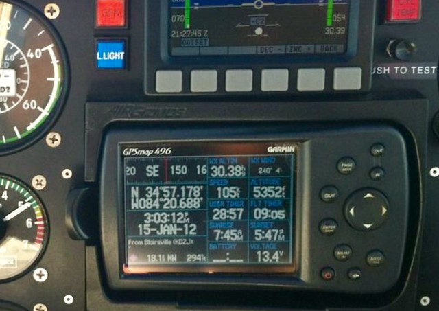
What I have no idea of is 1) other than smokestacks, what are usually the easiest to read, when wind is ten knots or so? And 2) I'm guessing altitude has a lot to do with it. But you'd want to know ASAP too, so indicators at lower AGL would be a little late to adjust planning I guess. Which indicators can be seen at say 1000 or 2000 feet?

Also, in non emergency, say a small airfield, power is ok, but no wind sock, etc.
Here you would have the luxury of being able to wait to judge wind. Do you guys ever box the compass (I think it is called) flying arch main direction to see how or if you drift to judge wind direction and strength?

Also are there any things that can mislead? I was thinking trees, sometimes sway in the wind but maybe spring also back the opposite direction when if the wind is volatile?
 
Smokestacks, ripples on a lake, large flagpoles, amber waves of grain, trees for sustained winds are traditional. I suspect most, in the case of trees, can differentiate the movement produced by sustained wind direction from "bounce back." Let's add to the mix a GPS or DME readout of your groundspeed compared to your airspeed to get at least a small clue.

But, while it makes for a nice quiz, I have a basic issue with your question from a practical standpoint. Your question assumes you were transported from your bed, asleep, and awakened just in time for your engine to fail. IOW, it posits a complete lack of situational awareness. That you either have not been flying or at least not been paying any attention to your groundspeed, crab angle compared to ground track, have not periodically tuned in a nearby AWOS, and noticing the wind indications you have been passing along the way, although none may currently be in view.
 
I agree with midlifeflyer - one should have some general idea of the surface winds as one flies along.

In my case, I just try to remember the general direction, like "generally from the west". Even with a relatively light 10kt surface wind, there would be a 20kt difference in groundspeed between landing into and with the wind. Which makes for a huge difference in energy to be dissipated.

I have my Garmin getting weather, so I use it to update both surface winds and altimeter settings. I have one secondary screen set up to show those in the top two fields for the nearest reporting airport:

33635280262_7bbf1f2fbc_z.jpg
 
One day I did this to practice something like this in case I had no clue as to the wind direction or speed. I used my GPS. I watched Ground speed. I flew north, then south, then east and west. I watched not only ground speed but took my feet off the pedals. I let the airplane feel the wind. I found I had a sw wind of about 10 mph and set up to land to the west. I wanted to check and see if I was right and over flew the runway looking at the wind shock. I saw indeed I had a sw wind. Not sure if anyone else did this or used the GPS ground speed for this but it worked for me.

Tony
 
Great point, G1000 has a wind reading and I have wondered what will happen when that thing goes blank or I don't have one in a plane. I have been taught to judge it from how the plane is flying in reference to a straight object on the ground, road etc. Trees and corn fields are fine, but 6 months here... there ain't any leaves, dust, water, grass...anything other than snow. Though u can see the snow drifting on the road , kinda hard to judge from 4-5k though

Sent from my SM-G935V using Tapatalk
 
When you gain experience, you'll be able to SEE the crab angle if it's more than a degree or two.
 
Great point, G1000 has a wind reading and I have wondered what will happen when that thing goes blank or I don't have one in a plane. I have been taught to judge it from how the plane is flying in reference to a straight object on the ground, road etc. Trees and corn fields are fine, but 6 months here... there ain't any leaves, dust, water, grass...anything other than snow. Though u can see the snow drifting on the road , kinda hard to judge from 4-5k though

Sent from my SM-G935V using Tapatalk
Ah, the discovery of one of the reasons for ground reference maneuvers! :cheerswine:
 
Lakes have wind shadows in the lee of anything that sticks up. Like you said, smoke or dust. The previous airport wind direction. Listen to the ASOS from the closest airport but not conclusisve. On final, its possible to compare your TAS to your GPS (groundspeed). The difference is headwind/tailwind component.
 
The wind direction on the surface usually diverges from that at altitude, at least when above 2K AGL or so; It seems to me to be about 30 degrees, most of the time. I think I remember reading the reason once, but it's slipped my mind. Only remember the effect because found it to be true, usually. I tend to note the winds aloft on the brief, and use that as a rough guide. Close enough in a 172, and if the field is short, you might just do a low approach, see the crab, look at the GS (GPS or eyeball) vs airspeed, if there aren't any other definitive visual clues. . .
 
If you see leaves, the bottom of the leaves are lighter color, and will show up more from the upwind side than the downwind side.
 
When you gain experience, you'll be able to SEE the crab angle if it's more than a degree or two.
This. And if it's only a degree or two, wind is not an issue. This, combined with enough situational awareness to have a general idea of the wind direction, should be all you need.
 
This. And if it's only a degree or two, wind is not an issue. This, combined with enough situational awareness to have a general idea of the wind direction, should be all you need.
There is the tailwind thing. When landing/crashing off airport, sometimes the best thing to go for is to just be as slow as you can when impacting
 
There is the tailwind thing. ...
Yup. That is the "situational awareness" part. If the situation today is that the wind is generally from the north, then don't line up on a field that is south of your location. Line up on one that is to the north.
 
Cows will usually stand with their hindquarters facing the wind. If about half the cows are standing facing one direction, the wind is about 15 knots. If all the cows are facing one direction the wind is 30 or more knots.
 
Cows will usually stand with their hindquarters facing the wind. If about half the cows are standing facing one direction, the wind is about 15 knots. If all the cows are facing one direction the wind is 30 or more knots.
A few here would probably call BS on that, but having grown up on a cattle ranch and many hours flying over the plains of CO, I can attest to that fact. ;)
 
If you slowly turn the airplane at a steady airspeed and note your GPS speed, the slowest GPS speed will put you in the direction of directly into the wind.
 
Lakes have wind shadows in the lee of anything that sticks up. Like you said, smoke or dust....
Fly on floats for a while and you become very proficient at reading lakes. The calm/flat spot on the shoreline is pointing in the direction of the surface wind. Usually, the smaller the calm spot the higher the wind. Above 10-15 kts and you have streaks on the water parallel to the wind.
 
Yes, most lakes have a dirt or rock bank and sometimes trees on the shore, with water with no or fewer ripples next to them indicating the leeward of the wind. When the bank is big, the lee is big. When the bank is small, the lee is small.

lee, leeward
The sheltered side; the side away from the wind.
 
Last edited:
What if those lakes are frozen over and there are no leaves on the trees? ;)

That means its winter.

Go back to the base and put on your skiis. Then come back and look for snowdrifts. They tell you which way the wind is blowing, sometimes... :)
 
I fly mostly long XC. Comm 1 is on ATC FF and Comm2 121.5 the majority of the time. On a 4 hour flight it gets boring, so tuning in AWOS frequencies about 2x per hour also helps break the monotony ... only other "monotony break" is fuel tank changes. In far west Texas even ATC gets quiet, so occasionally will even fire up the ADF and tune in an AM channel softly in the background.
 
Last edited:
I fly mostly long XC. Comm 1 is on ATC FF and Comm2 121.5 the majority of the time. On a 4 hour flight it gets boring, so tuning in AWOS frequencies about 2x per hour also helps break the monotony ... only other "monotony break" is fuel tank changes. In far west Texas even ATC gets quite, so occasionally will even fire up the ADF and tune in an AM channel softly in the background.

My first instructor had good advice: "If you don't have anything to do, find something to do"

This is a great example of that.
 
I fly mostly long XC. Comm 1 is on ATC FF and Comm2 121.5 the majority of the time. On a 4 hour flight it gets boring, so tuning in AWOS frequencies about 2x per hour also helps break the monotony ... only other "monotony break" is fuel tank changes. In far west Texas even ATC gets quite, so occasionally will even fire up the ADF and tune in an AM channel softly in the background.
Oh my god! Don't you know that XC flying (according to the "Peanut Gallery" here) is very dangerous and requires you to always be watching your instruments, monitoring your weather, checking your waypoints/landmarks, avoiding traffic, etc. etc. You're never ever supposed to be bored, as you should always be busy managing your cockpit, you know turning dials, pushing buttons, talking to ATC every minute.

Just kidding with you... flown across the Texas prairie many times. I know exactly what you mean. ;)
 
With a good preflight briefing with metar data, it would be easier to ballpark the surface winds. If you have a good EFB, the meta data would be available. In the absence of obvious signs, such as smokestacks, etc. but this won't be something you'll be thinking about. When the engine, quits its Airspeed, Best Field, Mags-Master-Mixture rich-Fuel fullest-Fual pump on (if equipped). Other signs such as tree signs and ripples are going to be pretty hard to see until you are VERY close to the ground.
 
Other signs such as tree signs and ripples are going to be pretty hard to see until you are VERY close to the ground.
I disagree. I can see swells on the ocean from thousands of feet up, and from on-shore. And whitecaps if it's really windy.

When I cross the Bay at 2000, I can see ripples if it's windy.
 
Smokestacks, ripples on a lake, large flagpoles, amber waves of grain, trees for sustained winds are traditional. I suspect most, in the case of trees, can differentiate the movement produced by sustained wind direction from "bounce back." Let's add to the mix a GPS or DME readout of your groundspeed compared to your airspeed to get at least a small clue.

But, while it makes for a nice quiz, I have a basic issue with your question from a practical standpoint. Your question assumes you were transported from your bed, asleep, and awakened just in time for your engine to fail. IOW, it posits a complete lack of situational awareness. That you either have not been flying or at least not been paying any attention to your groundspeed, crab angle compared to ground track, have not periodically tuned in a nearby AWOS, and noticing the wind indications you have been passing along the way, although none may currently be in view.

Ok, I agree. And hopefully by the time I get to my first solo xc I will be a lot less hurried, and what seems today to be more than enough to keep "track of" will not be so much by them, I'm just not the yet.

Also working on ground school Nav. Guessing that if there is a crosswind component sure..I'd be keeping track of that even just naturally, but the head/tail wind unless I'm wrong here would only be discovered by my GS calculations matching or not? Also at higher altitudes the ground wind can be in a diffent direction, right?

I'm thinking that experienced pilots like yourself may even take in a lot more information just without having to rally think about it?

My first instructor had good advice: "If you don't have anything to do, find something to do"

This is a great example of that.

That is a good one to remember. For us low time students I think we never feel we have nothing to do. We keep feeling like we have to concentrate to keep the plane flying :) even though our CFI's keep showing us it is much less than we think and the trimmed plane is flying on its own with no real help from our input.
 
Ok, I agree. And hopefully by the time I get to my first solo xc I will be a lot less hurried, and what seems today to be more than enough to keep "track of" will not be so much by them, I'm just not the yet.

Also working on ground school Nav. Guessing that if there is a crosswind component sure..I'd be keeping track of that even just naturally, but the head/tail wind unless I'm wrong here would only be discovered by my GS calculations matching or not? Also at higher altitudes the ground wind can be in a diffent direction, right?

I'm thinking that experienced pilots like yourself may even take in a lot more information just without having to rally think about it?


That is a good one to remember. For us low time students I think we never feel we have nothing to do. We keep feeling like we have to concentrate to keep the plane flying :) even though our CFI's keep showing us it is much less than we think and the trimmed plane is flying on its own with no real help from our input.

Yeah, you do pick up a lot of wind information unconsciously after a while.

For instance, flying over mountains, I can feel when the wind is giving me lift, and that tells me roughly which way it's blowing. It's a bit disorienting when it blows the "wrong" way, which happened this last Sunday. "Why the hell am I getting lift on the east side of Sunol Pass?" Strong (north)easterly wind. Normal is westerly. I fought a damn 25 knot headwind all the way to Sacramento and was 15 minutes late for my meeting because of it. Yes, the wind direction was different (and not as strong) on the ground. Landed on 30 at SAC, with the wind almost straight down it.

You also naturally align the nose along the runway with the rudder, upon landing, without much if any thinking about it. Even if the wind is all over the place.
 
Oh my god! Don't you know that XC flying (according to the "Peanut Gallery" here) is very dangerous and requires you to always be watching your instruments, monitoring your weather, checking your waypoints/landmarks, avoiding traffic, etc. etc. You're never ever supposed to be bored, as you should always be busy managing your cockpit, you know turning dials, pushing buttons, talking to ATC every minute.

Just kidding with you... flown across the Texas prairie many times. I know exactly what you mean. ;)

My G-530 has a "nag" alert for OPs check from the previous owner. I don't need it as I'm constantly scanning for traffic than instruments, but as you get in the middle of El Paso and Austin, there isn't any traffic except in the flight levels. Flight service appreciates PIREPS, but I was asked by flight service to keep them 100 miles apart on one trip. So now I keep it down to two usually in the middle or if there's something unusual.

If flying somewhere new, I already have all the frequencies jotted down on the kneeboard as well as TPA, etc. All Notams along planned route are in a PDF that I look at if things get real boring. After you fly more than 500 hours, your efficiency is very good and I can't remember the last time I was task saturated.
 
The easiest one to see is smoke. If I did not have a good visual cue after a few seconds scanning around, It might take me 10 seconds to bring up surface wind on my foreflight map with ads-b
 
Ok, I agree. And hopefully by the time I get to my first solo xc I will be a lot less hurried, and what seems today to be more than enough to keep "track of" will not be so much by them, I'm just not the yet.

Also working on ground school Nav. Guessing that if there is a crosswind component sure..I'd be keeping track of that even just naturally, but the head/tail wind unless I'm wrong here would only be discovered by my GS calculations matching or not? Also at higher altitudes the ground wind can be in a diffent direction, right?
Exactly. One of things you learn in cross country planning is choosing checkpoints along the way. The exercise is to compare the groundspeed calculated in advance based on the wind forecast with reality. That has a number of purposes, the primary one being, "do I have enough fuel" but that groundspeed check has some other purposes as well. And whatever you are using - Manual E6B, calculator, app - to predict your required heading and groundspeed can be run backwards to give you the actual winds. And even a estimate gets you in the ballpark for emergency landings.
 
Performance on the "downwind"
Trees
Smoke
Water
Prevailing trends
 
Aside from low level aircraft performance and feel...

30js7b6.png
 
If flying somewhere new, I already have all the frequencies jotted down on the kneeboard as well as TPA, etc. All Notams along planned route are in a PDF that I look at if things get real boring. After you fly more than 500 hours, your efficiency is very good and I can't remember the last time I was task saturated.
Yea... but, but, but... according to some here, you're always supposed to be super busy watching your instruments or the magenta line, or keeping your plane level, and all that good stuff. All kidding aside, I'd usually make a mind game out of always scanning for places I could put down if VFR, or would pull the charts if in IMC conditions and run the calculations (pre GPS days) of where our position (or future position) would be along the route, and look for places that I deemed would be landable or survivable. To me, that was half the fun of flying.
 
Back
Top