labbadabba
Pattern Altitude
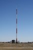
What do the towers look like? Just normal radio towers?
What do the towers look like? Just normal radio towers?
Pardon me while I have a tantrum:
So the government could not AFFORD to keep a dozen Loran towers running, but we can afford 450+ and growing towers for this. (primal scream)
John, just wondering, if the lat/long was in the wrong format in a user's screenshot, why not just do the conversion?
Sent from my iPad using Tapatalk
This is the tower at Glasgow, Montana.What do the towers look like? Just normal radio towers?
You can download the file of ground station locations that I have compiled to ForeFlight. So far, I have collected 510 locations and they can be downloaded from:
https://dl.dropboxusercontent.com/u/58910037/user_waypoints.kml
When I saw the .kml suffix i thought, o poop, i can't use that file. but downloaded it anyway. WOW it opens with Google Earth no problem, exactly what I've been looking for! Thank you SO very much, Mr Collins!
You are welcome, if you have ForeFlight, you can also download the .kml file as a set of user waypoints. Up to 536 so far. still looking for more.
ForeFlight will plot the locations of user waypoints by turning on the user waypoint layer. I use the technique you describe to locate towers that are not in the database. I am up to 557 out of 634 the FAA claims. Thru a FOIA case, I expect to get all of the locations this year. FOIA has already ordered it, waiting on final adjudication.
")
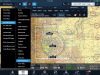
There are four tiers of tower types. High, Medium, Low, and Surface. The High and Medium provide the CONUS NEXRAD product. On ForeFlight, you can display the towers if you have a compatible ADS-B In receiver. They are labeled High, Med, or Low. See the screenshot.John, is there any way to determine which of the towers transmit CONUS radar?
.png")
Enhanced loran is coming back....other nations are already using it and our government can't ignore the GPS backup consideration much longer.
John,
Thanks for all you've done on this subject.
As to a backup for ADS-B, as I understand it, the FAA's existing radar system is supposed to be the backup today, and probably for a long time. Originally, radar was supposed to go away, in order for the FAA to save money, but it can't since TCAS systems use it... which is also why we can't get rid of our Mode C transponders.
So where did Foreflight get the data if not the govt?
Sent from my iPhone using Tapatalk
No I mean Foreflight already displays ADSB tower locations, if you can't get the info from the government how did they? (Evidently)
The skydiving jump plane we saw on the ground while we were airborne doesn't have ADS-B out, in, or otherwise.
Hi, John this is a neat work you did there. I gone through your complete posting and lot of useful information, Thanks for sharing this. I basically develop things as part of the ADS-B receivers and display. Wondering if there is a way to determine the Tier Category (High, Med, Low or Surface) of the tower which I am receiving. I do not see this information encoded directly in to the messages. I read the information from industry standards, couldn't understand it clearly though. Do you know anything about that? Also, the look-ahead ranges are nothing but coverage for the weather product? Appreciate your response.