Navigating cluster thunderstorms -- Go IFR or VFR?

I'd also do this trip with your equipment. I'd definitely file IFR with the intention to remain VMC. Also, keep looking ahead at your ADS-B weather image and suggest route changes to the controller that will keep you clear of the weather. As others have said the controllers will be telling you of weather up ahead and will even suggest vectors if you ask them. The good news about your altitude high teens is that it is not very busy so you can ask for left and right deviations and stay VMC without worrying about maintaining VFR cloud separation. And then of course always have an out so that if the weather starts look too exciting up ahead, you can land somewhere and reevaluate
 
I'd also do this trip with your equipment. I'd definitely file IFR with the intention to remain VMC. Also, keep looking ahead at your ADS-B weather image and suggest route changes to the controller that will keep you clear of the weather. As others have said the controllers will be telling you of weather up ahead and will even suggest vectors if you ask them. The good news about your altitude high teens is that it is not very busy so you can ask for left and right deviations and stay VMC without worrying about maintaining VFR cloud separation. And then of course always have an out so that if the weather starts look too exciting up ahead, you can land somewhere and reevaluate

This is something I would not do. I have not found ground based radar distribution to be timely enough for tactical navigation through storm fronts. Flying back to Atlanta from OSH with my buddy in his Travelair we had a similar but larger front to deal with, I had left seat he had right. I am steering around the dark masses and staying under the lighter and things were looking good ahead. ATC calls me tells me they are seeing a heavy cell in front of me that I'm not seeing out the window and suggests a 60° turn to the right, my buddy who has been head down in the 496 looking at the weather says "Yep, you better turn right, we've got a big cell in front of us. I told him to look out his side window. The cell had already moved and that 60° turn would have put us straight into the nastiest bad assed black cloud of the trip that I was skirting. I called back ATC, "60° to the right will put me smack into a black cell, I am currently in the clear under light grey skies and I can see the sunshining ahead in about 30 miles." He immediately calls back a Mooney he had vectored that way and told him I was ahead and in the clear and gave him new vectors to get behind me.

Ground based weather radar is for strategic planning only, when I'm still 100 or more miles out, so I can see how everything is trending and where my best odds of getting through will be. Once I'm there, that stuff is only secondary information.

Serious convective weather requires either onboard transmitting radar equipment, or eye balls, to penetrate safely IMO.
 
Last edited:
I'd also take a look at the satellite imagery which Foreflight does really nicely. If it's widely covered in the orange and higher you have less of a chance of staying VMC. if it's mostly gray with some blue and orange around the storm activity, you'll be easily able to get above the low level scattered cumulus and keep an eye out for the storms and large cumulus build ups.


Great tip on the satellite color coding for top temps!

Here's this morning's picture from the time we'd be arriving tomorrow. This would be a no-go for me. So much for "going early beats the storms"!

d0c4c05830970c356da2d87fb1f33149.jpg


555861eccd52ab1a14f3143a31f2a830.jpg
 
PA46 with radar?

My understanding is both ATC and ADSB/XM use a similar product for radar, and IMO the lag time is a big problem when it comes to close range navigation near imbedded stuff, and convective activity in general where 5 minutes can be a lifetime.


We have NEXRAD onboard as well, it's great for keeping a eye on the big picture, however going IMC without real radar in those conditions :hairraise:


YMMV
 
This was a valuable thread, and I hope the conversation continues. I'd welcome the opportunity to do some weather flying with somebody more experienced, like Jesse...

We decided to drive, not fly... Too much thunderstorm activity down there today and forecasted to continue through tomorrow. We don't have enough flexibility in our planned events to make that work, so pulling he plan B card: ROAD TRIP!

Staying tonight in Vicksburg, MS (hah, déjà vu, flew there this past Sunday for an Angel Flight mission!) and then continuing to Panama City Beach tomorrow. Will book commercial airfare for the Bahamas leg.
 
Last edited:
This is something I would not do.

...

Ground based weather radar is for strategic planning only, when I'm still 100 or more miles out, so I can see how everything is trending and where my best odds of getting through will be. Once I'm there, that stuff is only secondary information.

Serious convective weather requires either onboard transmitting radar equipment, or eye balls, to penetrate safely IMO.

:dunno: Did I say anything about penetrating a line of storms? The stuff in bold is exactly what I'm talking about. You can look 200 miles ahead and see a cluster of storms and choose a route that will take you well clear of it many times. I do this all the time and I have onboard radar. I still use the XM weather to decide far in advance how to steer clear. Of course you don't use the nexrad data for penetrating storms.
 
PA46 with radar?

My understanding is both ATC and ADSB/XM use a similar product for radar, and IMO the lag time is a big problem when it comes to close range navigation near imbedded stuff, and convective activity in general where 5 minutes can be a lifetime.


We have NEXRAD onboard as well, it's great for keeping a eye on the big picture, however going IMC without real radar in those conditions :hairraise:


YMMV
Strike finder, nexrad, and mark 1 eyeballs. Just because you spend a lot of time in IMC around some of these systems does not mean you're doing so near the convection that could ruin your day.

In this case it was a fairly large (hundreds of miles) mess of precipitation that was stalled out not moving and not changing in intensity over the course of many hours. There were nasty parts but they were not developing, were not moving, visual of them was established over 100 miles out before entering IMC and the strike finder painted the same picture that both nexrad and our eyes painted. Deviate as needed to keep a wide gap from that stuff, but in this case that didn't mean deviate so much you don't enter IMC.

Every situation is different and typically speaking those that I hear say operating under IFR brings no advantage near thunderstorms typically either don't have an instrument rating or are not proficient under IFR.

Operating under IFR brings nothing but benefits when dealing with weather and most certainly does not mean atc will or can make you enter IMC near convection if you don't want to do so.

IFR != IMC and that seems to be a connection some people struggle with :)
 
Operating under IFR brings nothing but benefits when dealing with weather and most certainly does not mean atc will or can make you enter IMC near convection if you don't want to do so.

IFR != IMC and that seems to be a connection some people struggle with :)

Just a comment, I've asked ATC for and received help with weather with just flight following. Of course with flight following they can drop you at any time...
 
Even if I file IFR, I want to stay VMC on this trip.

Filing will let you pick it up in route when you want to start through clouds instead of trying to drop below or fly above them.
 
I'd rather be IFR all day long. The question is what your method of storm detection is. Even if you say "visual underneath looking for rain shafts" I'd still stay IFR. Just being IFR doesn't mean one must fly the vector given by ATC and it doesn't mean one must fly in a dead straight line. But it does give one the option to enter clouds as needed. ATC knows when there

My preference would be to remain as high as possible and stay out of the clouds and monitor storms via ADS-B. Because nearly every cloud is at least building, if not towering, cumulus, I don't want to be in clouds for the most part. But being IFR I do have the option if there are benign clouds I need to pass through on descent.

Given that the OP has a TR182, he has bookoo options with respect to altitude. The higher you go, the more direct you can go and remain clear of clouds too.
 
Last edited:
Flying underneath often doesn't work IFR due to altitude excursions and getting lost off the radar. FF works just as well.
 
PA46 with radar?

My understanding is both ATC and ADSB/XM use a similar product for radar, and IMO the lag time is a big problem when it comes to close range navigation near imbedded stuff, and convective activity in general where 5 minutes can be a lifetime.

We have NEXRAD onboard as well, it's great for keeping a eye on the big picture, however going IMC without real radar in those conditions :hairraise:

YMMV
Well, my mileage definitely varies. I've never flown with radar but have had Nexrad data since before the beginning, i.e. on Cheap Bastard running on an RF Palm device. Cockpit Nexrad is a game changer for everyone, particularly those without access to onboard radar.

First, I don't really know how ATC and ADSB/XM products are similar but it is pretty clear to me that ATC has no time delay. Agreed?

ADSB certainly does have a time delay. It's not a big deal as long as it's accounted for.

Jesse did a good job of describing how Nexrad imagery can be used in thunderstorm studded skies. Here's my take.

I decided some years ago while flying IFR in IMC conditions that penetrating clouds that contain convective storms is not something I will be doing any longer. I've flown into IMC with embedded storms and scared the crap out of myself. I've battled a few (very few) convective storms without AP or any information other than that provided by ATC. I don't do that any longer.

What I will do is fly cross country on stormy afternoons with an AP, Nexrad and as much ATC help as I can get. I stay visual 90%+ of the time. Let me say that again, I stay in visual contact with enough of the external environment to hand fly the airplane 90%+ of the time. I only penetrate clouds where and when I know where I will exit same cloud - and mainly do it for expediency because it's on my course. Otherwise I stay out of solid IMC conditions. I stay out of convective storms. I may get wet, I met get tossed a bit but I stay visual.

Obviously I fly on an IFR plan and clearance. That makes the cloud penetration legal. More important it keeps the lack of VFR cloud clearances legal. Much of my flying is right up against clouds... sometimes storm clouds. Flying on an IFR clearance is the best way to do this kind of flying with few exceptions. Whether VFR and IFR, ATC's help is always sought and welcome. They have good information and even better experience. Stupid to do otherwise.

I rarely make loggable IFR approaches in these conditions. Most approaches are visual because the conditions are visual. IFR approaches are for low ceilings and generally stable conditions.

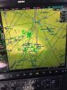
This is a flight I made today:
http://flightaware.com/live/flight/N215TG/history/20150806/1900Z/KSSI/8NC8

I was pretty confident it could be completed as planned but my passenger and I were more than well prepared to land somewhere else and wait things out. We didn't have to. It was a fun and interesting flight.

Twice during this flight I saw the effect of Nexrad delays. In one case I saw a strong, fresh buildup with rain about 3 minutes before there was any indication on my ADSB Nexrad display. But I was visual at 9,000' so this counts as 'calibration of Nexrad with my mark 20 eyeballs'. That is, no problem.

In the other case I asked for a right turn to direct final destination when about 30 miles out and 5,000'. I was skimming just below cloud base. RDU approach was very busy at that point and responded with, "turn left 20 degrees for weather" (!!) While I could see along my final course with just a bit of haze, I couldn't see the sudden buildup forming overhead, above cloud base, between me and my final destination. Within a minute or two, the Nexrad imagery filled in as the first strokes of lightening marked by previously requested course. These storms were forming quickly and the Nexrad update time was a real factor but manageable because I was visual and getting help from ATC. When I cleared the line of clouds overhead I requested direct, got it, then canceled IFR for the final 15 miles or so.

Few people talk about what Nexrad does better than anything else and that's seeing around corners. Like Superman! No attenuation, no elevation or azimuth adjustment, just a complete, slightly aged picture. When Nexrad was still new in the cockpit it was fun being able to complete flights when the radar equipped jets were stuck. It wasn't long before G396s seemed to be in everyone's cockpit but for a few months, maybe a year, it was very 'interesting' out there buzzing around with the G396. And Cheap Bastard was just plain 'magic' when it was the only game in town.

My experience is primarily in the SE US. I've flown conditions across the country and know things are different....I don't necessarily know exactly what's different but things are different. Nevada cloudbases at 18,000 feet or above are completely different. Texas storms along the 'dew line' or whatever are different. Giant midwest hail spewing green monsters are different. But Nexrad makes a lot of things possible and safe for light planes that simply weren't in the past.

Debate is fine with old school naysayers but if I'm flying a light plane cross country with Nexrad as my primary storm avoidance tool, I'd say get some experience with it, learn to use it and find out just how effective it can be in getting you where you want to be safely.
 
Well, my mileage definitely varies. I've never flown with radar but have had Nexrad data since before the beginning, i.e. on Cheap Bastard running on an RF Palm device. Cockpit Nexrad is a game changer for everyone, particularly those without access to onboard radar.

First, I don't really know how ATC and ADSB/XM products are similar but it is pretty clear to me that ATC has no time delay. Agreed?

I think that may be variable, because as I indicated in the post above, what the controller was telling me jived exactly with what was displayed on the 496, neither of which was concurrent with reality out the window. In this part of the world it's rare to have 'safe' clouds, if I don't have real time radar in the plane, I'm staying eyes on.
 
PA46 with radar?

My understanding is both ATC and ADSB/XM use a similar product for radar, and IMO the lag time is a big problem when it comes to close range navigation near imbedded stuff, and convective activity in general where 5 minutes can be a lifetime.


We have NEXRAD onboard as well, it's great for keeping a eye on the big picture, however going IMC without real radar in those conditions :hairraise:


YMMV

The majority of approach facilities are using ASR-11 these days. That's a 30 sec update on weather. Even the old analog radar (ASR-8) that I used updated weather every sweep. I'll take that any day over XM WX updates.
 
VFR with two sources of nexrad.

I run a 696 hard wired to a GDL-39 and Garmin pilot BT'd to it.

The 430W drives the A/P.
 
If anyone really thinks you can pick your way through convection with just XM or ADS-B, check out the images below. They were all taken a few seconds apart. The first is a pic of my MFD showing me flying right through a cell, the second is the view out of the windscreen at the time and the third is the view off my left wing. Had I been relying on Nexrad and deviated left, I would have flown right into that cell, which was not sparking at the time so a stormscope would not have helped.

It's true I was 100% visual, but that's not always the case.
 

Attachments

  • IMG_1587.jpg
    IMG_1587.jpg
    16.1 KB · Views: 35
  • IMG_1588.jpg
    IMG_1588.jpg
    11.1 KB · Views: 31
  • IMG_1589.jpg
    IMG_1589.jpg
    11.2 KB · Views: 32
I hate to just "me too" this thread, but my son and I just completed a great flight IFR through early building CBs, and I have to agree that ATC granted every diversion I requested, and granted everyone else on the freq as well. I evenenetrated a few small buildups on purpose to let my son know what they were like. IFR really gave me all of the control in terms of my heading through the system, and the fact that I could pick my way around the towers was really key. I suspect that if a particular deviation did not work for ATC, we could absolutely have negotiated a better option.

I understand the flexibility of going VFR through crowded controlled airspace, but for cross countries over a lot of open space, IFR surprisingly offers MORE options.
 
...


Few people talk about what Nexrad does better than anything else and that's seeing around corners. Like Superman! No attenuation, no elevation or azimuth adjustment, just a complete, slightly aged picture. When Nexrad was still new in the cockpit it was fun being able to complete flights when the radar equipped jets were stuck. It wasn't long before G396s seemed to be in everyone's cockpit but for a few months, maybe a year, it was very 'interesting' out there buzzing around with the G396. And Cheap Bastard was just plain 'magic' when it was the only game in town.

...

Debate is fine with old school naysayers but if I'm flying a light plane cross country with Nexrad as my primary storm avoidance tool, I'd say get some experience with it, learn to use it and find out just how effective it can be in getting you where you want to be safely.

If anyone really thinks you can pick your way through convection with just XM or ADS-B, check out the images below. They were all taken a few seconds apart. The first is a pic of my MFD showing me flying right through a cell, the second is the view out of the windscreen at the time and the third is the view off my left wing. Had I been relying on Nexrad and deviated left, I would have flown right into that cell, which was not sparking at the time so a stormscope would not have helped.

It's true I was 100% visual, but that's not always the case.

I posted these the above to posts together ( I've selected certain portions of Bill's to include) because I think they describe well what I see as the conflict with use of Nexrad.

I agree with Bill that Nexrad is a fantastic tool in the cockpit . I would use it as a strategic tool but not a tactical tool. My experience and understanding however aligns more with the post from Wingsofglass. My understanding is that Nexrad is not a good tool for looking around corners or more accurately behind systems.

Two things stand out in my mind regarding Nexrad one of which is similar to the post by WoG. 1) Several Junes ago while flying to Gastons from Southeastern PA. Just east of Elizabethtown KY our 396 showed two large cells in front of us moving IIRC from North to South. They were close together and according to Nexrad blocking our intended flight path ( we were VFR). The visual however did not mesh with the Nexrad data. The cells had moved off to the South and the other were actually a decent distance to the south of us leaving our path clear to Elizabethtown ( fuel stop)

The second is a post I think on POA a few years back by Scott dennstaedt, who showed some screen shots of a nexrad display that was something like 15 minutes old, I can't recall the exact details but it was pretty scary. From what I recall the screen shots were from somewhere in the Southeast U.S. The images showed a pretty clear area and then he posted so screen shots of the actual and the Wx depicted was pretty severe. If I recall correctly and I admit I am going on some foggy memory he also posted some images of cells hidden behind other less benign Wx. I also seem to recall a post where Nexrad images were clear but Nexrad was down for some reason and the Wx was very bad and it gave a false impression that it was ok. I'll see I can search for his posts to see if my memory is accurate.
 
The majority of approach facilities are using ASR-11 these days. That's a 30 sec update on weather. Even the old analog radar (ASR-8) that I used updated weather every sweep. I'll take that any day over XM WX updates.


Thanks for the clarification about ATC radar. As I mentioned before, whatever they are using now seems more accurate than what they had in the past. It sometimes overstates the precipitation intensity but that's better than the opposite.
 
It's today right? Right now?
What's his N-number, we could flightaware him.
The radar looks pretty good right now.
 
I posted these the above to posts together ( I've selected certain portions of Bill's to include) because I think they describe well what I see as the conflict with use of Nexrad.

I agree with Bill that Nexrad is a fantastic tool in the cockpit . I would use it as a strategic tool but not a tactical tool. My experience and understanding however aligns more with the post from Wingsofglass. My understanding is that Nexrad is not a good tool for looking around corners or more accurately behind systems.

Two things stand out in my mind regarding Nexrad one of which is similar to the post by WoG. 1) Several Junes ago while flying to Gastons from Southeastern PA. Just east of Elizabethtown KY our 396 showed two large cells in front of us moving IIRC from North to South. They were close together and according to Nexrad blocking our intended flight path ( we were VFR). The visual however did not mesh with the Nexrad data. The cells had moved off to the South and the other were actually a decent distance to the south of us leaving our path clear to Elizabethtown ( fuel stop)

The second is a post I think on POA a few years back by Scott dennstaedt, who showed some screen shots of a nexrad display that was something like 15 minutes old, I can't recall the exact details but it was pretty scary. From what I recall the screen shots were from somewhere in the Southeast U.S. The images showed a pretty clear area and then he posted so screen shots of the actual and the Wx depicted was pretty severe. If I recall correctly and I admit I am going on some foggy memory he also posted some images of cells hidden behind other less benign Wx. I also seem to recall a post where Nexrad images were clear but Nexrad was down for some reason and the Wx was very bad and it gave a false impression that it was ok. I'll see I can search for his posts to see if my memory is accurate.
I think this discussion keeps dancing around a major point of agreement;
  • the key to using Nexrad imagery for moving around convective activity is to stay visual.
  • Or to state it in a more critical way; you can't depend on Nexrad imagery to be entirely accurate or timely, therefore you shouldn't go plunging into convective systems unless you stay out of the clouds.
If you find yourself agreeing with either of those statements I think we are on the same page.

Leaving aside the 'tactical' and 'strategic' terminology because I think they mean different things to different people, Nexrad is the clearly the best tool for looking at current conditions when sitting on the ground planning a flight. It is the only tool except perhaps for pilot reports and there's never enough of them to be very useful except relative to icing.

Pilots have always been trying to penetrate storms to maximize the utility of flight 'forever'. Before Nexrad there was on board radar (and Stormscopes). With the need to get from here to there ever in mind, pilots used these tools to pick their way through weak spots in frontal systems and storm clusters.

We've finally come to accept that no suite of equipment guarantees successful passage no matter how heavy the equipment or powerful the radar. Maybe some airline people can pipe in here but my sense is that everyone backed off from some operations considered okay in the 60s and 70s, that are now considered no-go situations. We found out about downbursts and measured the intensity of the most powerful storms. And now it seems even with some newer ground based aids and even better airborne equipment we just say 'no' to weather we used to try and penetrate or land in... no?

Yes or no, today's light plane pilot has a tool that allows safe and comfortable flight in conditions that were previously a lot more difficult and challenging to fly in. It has limitations like all this stuff but within certain limitations and with skills developed through experience, it greatly increases the utility of light planes in the stormy weather we typically have here in the SE US.

I've had exactly the same experience that WingsofGlass described. I expect them to occur. But I can still negotiate my way through systems like this Aug 6th flight KSSI to 8NC8 safely and with confidence using Nexrad. ('safely and confidently' presumes an alternate may be required, BAU).

In this example from yesterday I spent less than 20 seconds in cloud and it was entirely by choice. And that's the key, I stayed visual and stayed clear of anything I thought could hurt me (or disturb my very entertained pilot passenger). I experienced 2 Nexrad display surprises on this final leg of the flight but neither was a problem. At the same time I wouldn't have even attempted the final let if I hadn't been able to both see around corners and predict future storm movement so that I had some sense of whether to deviate left or right, now or later.

I guess I would say there is a set of skills that one can develop with Nexrad that allows a lot of SE US 'storm penetration'. Perhaps it might better be called 'storm avoidance and circumvention'. Whatever it is, if you are IFR capable, have Nexrad and get some experience with this kind of weather, there is no reason to call a situation like yesterday's a 'no-go' weather system. If you are lucky with the timing you might get in with minimal deviation. If unlucky you might have to land somewhere else and wait it out some. Lately I've been lucky but I expect that to run out sooner than later but that's no problem.
 
Last edited:
STORMSCOPES
Stormscopes detect more than just what we would call true "lightning" - they often detect smaller static discharges within clouds that wouldn't amount to lightning by ground-based detectors and thus not show up on ADS-B. When approaching a cloud, the storm scope often tells whether that cloud is building rapidly (violence inside) or if it's rather benign.

Even having a stormscope and Nexrad, I like to stay visual most of the time. I'll bust through a building cumulus if it isn't very wide and if I'm near the top of it and if the overall cloud cover at my altitude is what I would consider few to scattered. If they are much taller than I am, I just go around them or climb until all the puffies are below me. That is a nice option to have that comes with the turbo. Since my ceiling is 20k feet, I'm not able to climb over anything serious.

If you're paying attention, it isn't hard to figure out what is generally going on. For example, in convective areas like Texas I watch the cumulus forming below me and I start looking for clouds that are popping the top. And I look for buildups in general. I don't want to be up there and have the whole sky build up into me. You can tell by the forecast and just by watching what is happening - and I take off with a backup plan in mind.

NEXRAD
I've actually had pretty good luck over the past year with NEXRAD lining up pretty well with my eyeballs. But the caveat is that I don't push into stuff that's building rapidly such that I'd be using Nexrad as a tactical tool. I fly in the morning as close to exclusively as possible in the summer. My rule is that I will fly through patches of green if there is nothing but light and dark green and the worst are widely scattered patches of yellow but when nothing is building, and preferably dissipating. In that situation, the clouds are relatively stable and the rain is patchy and widespread. This is not really convective stuff. Think Texas in early spring or Colorado in late spring before the gnarlies begin. I will fly through morning rainfall that may be patchy leftovers of garden-variety cells from the night before. Not talking about dying cells that can contain microbursts - not even virga. Trends are critical when evaluating NEXRAD.

FALSE PRECIP ON ADS-B NEXRAD
I have seen one instance where my ADS-B NEXRAD indicated FALSE precipitation. It happened near Limon, Colorado probably about a year to 1.5 years ago. It showed an area of strong precip (I think the maximum was one or two blocks of pink along with red, yellow and green) right in my flight path that simply was not there. I checked the update time for the Stratus 2 and it was recent and persisted for many updates. I asked ATC if they showed any precip and they said no. I told them that my ADS-B was showing strong precip that simply was not there. Nothing they can do about it but it was just weird and I still don't know what caused ADS-B to show precip where there was nothing but clear air from surface to space.
 
Last edited:
Stormscopes detect more than just what we would call true "lightning" - they often detect smaller static discharges within clouds that wouldn't amount to lightning by ground-based detectors and thus not show up on ADS-B. When approaching a cloud, the storm scope often tells whether that cloud is building rapidly (violence inside) or if it's rather benign.

lightning isn't an ADS-B product
 
lightning isn't an ADS-B product

Yeah true, but my point is that the stuff a stormscope detects would sometimes not be considered lightning strikes by ground detectors. It can detect more subtle discharges at close range. I still wouldn't rely on it to pick my way through embedded cells in IMC.
 
Hi Dave! Yes, Friday morning is the plan. I'm just watching weather today and tomorrow and doing the "If it was today, what would I do?" chair flying / ADM.

Our goal is to depart just before sunrise Friday morning (about 6:30am). It's 4-4.5 hours enroute in Birdie (direct vs. typical airway routing), and we can go non-stop.

Well, I am glad to see I am not the only one who does the "what if"game. I just came back from Hilton Head last weekend, and ended up leaving one day earlier than planned due to a cold front that stalled and went stationary. Everything pointed to Friday being a better day. Well, as luck would have it, we were delayed 2 hrs Friday morning due to TS. Once airborne, and 20 miles to the west, pretty clear sailing. Did have to fly over a broken layer coming north toward Knoxville. Went up to 8500 VFR, and around a couple of clouds poking upward. Once past the mountains there, CAVU all the way to Ohio. This was my first long XC with the wife in over 15 years. Went pretty well. Still have to learn not to be overly anxious about the weather, 3 days out. I guess that comes with doing it more. I am IFR rated, but not current. Over 1000 hrs, with 350 hrs XC, but still seem to over analyze the weather leading into a flight. :dunno:
 
Well, I am glad to see I am not the only one who does the "what if"game. I just came back from Hilton Head last weekend, and ended up leaving one day earlier than planned due to a cold front that stalled and went stationary. Everything pointed to Friday being a better day. Well, as luck would have it, we were delayed 2 hrs Friday morning due to TS. Once airborne, and 20 miles to the west, pretty clear sailing. Did have to fly over a broken layer coming north toward Knoxville. Went up to 8500 VFR, and around a couple of clouds poking upward. Once past the mountains there, CAVU all the way to Ohio. This was my first long XC with the wife in over 15 years. Went pretty well. Still have to learn not to be overly anxious about the weather, 3 days out. I guess that comes with doing it more. I am IFR rated, but not current. Over 1000 hrs, with 350 hrs XC, but still seem to over analyze the weather leading into a flight. :dunno:

I suspect that many of us, myself included, who are not regular Wx flyers will perpetually "over analyze" which probably is not a bad thing.
 
Thing I learned about weather is it never is as forecast more than 36hrs out, and is about 50/50 at 18 hrs out, so I never really concern myself with it until then.
 
I never look at the weather until about a half hour before the flight. Looking earlier isn't going to change what the result is going to be and it won't take me more than a few minutes to decide if I should attempt the flight and what my strategy will be.
 
I know it's a moot point now for the OP, but regarding VFR versus IFR when there's anticipated convective activity, for every build-up you see on nexrad, there's plenty more that hasn't built up to the point of dropping precitation. By flying IFR, you can get deviations as necessary but you won't have to worry about cloud clearance requirements. It's real easy to bust VFR minimums climbing through a scattered layer to get up to a point were you can see the nasty stuff.

...and I agree with the recommendation not to worry about the weather until you have to. Unless taking off early is an option, I don't worry too much about weather until the morning of. Otherwise you're wasting your time and stressing yourself out.
 
I think some people, like Troy in this case, need to make the decision ahead of time because their alternate mode of transportation is slower. But it's also true that the weather is rarely exactly as forecast.
 
I think some people, like Troy in this case, need to make the decision ahead of time because their alternate mode of transportation is slower. But it's also true that the weather is rarely exactly as forecast.

It is never 'exactly as forecast', but there is a world of difference between crossing a dry and stable air-mass, a humid and unstable one and following a frontal passage. Forecasts suck at telling you where exactly you are going to encounter the storms, they are pretty good at forecasting whether it will be a stormy day.
 
This time of year, across the Southeast coast, popup thunderstorms (not squall lines) are the order of the day. There's also a lot of restricted and MOA airspace. Navigating the latter is easier IFR... but on a LONG cross country (4+ hour flight), which would you rather file--IFR or VFR--for flexibility in navigating well clear of thunderstorms enroute? Obviously, I'm not going to fly into a thunderstorm while IFR, regardless of the vector... and I imagine ATC in that region is very good at being "adaptable" to what needs to be flown due to the weather versus what you filed and were cleared for.

Making my first LONG X/C this week, starting Friday, and would like to hear your thoughts and comments on this topic.

Is what you see below, from today (Wednesday 8/5, 2022Z) navigable in your opinion, in a non-RADAR equipped single that has ADS-B weather and a Strikefinder on board?


attachment.php

You can always start out IFR. An advantage to that is you're in the system and aren't going to get terminated so you will have more timely SAR activation should something happen. If ATC is unable to keep you out of clouds that you don't like, going OTP can make it easier for them to approve deviations but they still won't authorize you to fly into a MOA. And of course you can cancel at anytime and go on your merry way VFR, but if you're in a Class B at the time it gets a little more complicated. Nothing to lose starting out IFR. If your concerned about SAR and think you might cancel, file and open a VFR plan before you depart. Don't forget to close it. If you stay IFR and don't cancel, you'll still have to close the VFR flight plan yourself.
 
You can always start out IFR. An advantage to that is you're in the system and aren't going to get terminated so you will have more timely SAR activation should something happen. If ATC is unable to keep you out of clouds that you don't like, going OTP can make it easier for them to approve deviations but they still won't authorize you to fly into a MOA. And of course you can cancel at anytime and go on your merry way VFR, but if you're in a Class B at the time it gets a little more complicated. Nothing to lose starting out IFR. If your concerned about SAR and think you might cancel, file and open a VFR plan before you depart. Don't forget to close it. If you stay IFR and don't cancel, you'll still have to close the VFR flight plan yourself.
Have to admit I'm not thinking of SAR when filing. But I'm generally east of the Mississippi.

I get clearances thru MOAs all the time but not if active I assume.

I can't remember canceling IFR (to loosen the constraints) and not have ATC keep me on FF usually with the same code. Especially with a Class B is involved... we both know what we're doing when we do that. NY ATC does everything but encourage it at times.

But, YMMV
 
It is never 'exactly as forecast', but there is a world of difference between crossing a dry and stable air-mass, a humid and unstable one and following a frontal passage. Forecasts suck at telling you where exactly you are going to encounter the storms, they are pretty good at forecasting whether it will be a stormy day.


But that lack of detail in forecasting can cause it to be hard to make a decision in advance.
 
It is never 'exactly as forecast', but there is a world of difference between crossing a dry and stable air-mass, a humid and unstable one and following a frontal passage. Forecasts suck at telling you where exactly you are going to encounter the storms, they are pretty good at forecasting whether it will be a stormy day.
For the past couple of years I've been quite amazed at the forecasting capabilities behind the TV new's "Future Cast" display (WRAL here in Durham NC). They show how precipitation patterns will develop over the next 24(+?) hours. It looks random but I've found it to be representative of actual storm locations and precip hour by hour across the local area.

Is that kind of thing available on a national basis and I'm missing it?
 
I never look at the weather until about a half hour before the flight. Looking earlier isn't going to change what the result is going to be and it won't take me more than a few minutes to decide if I should attempt the flight and what my strategy will be.

Yes I find the same. If you look too far in advance you don't get a realistic view of what is going to happen. Also, something else I've noticed, is that the weather forecast is usually pessimistic. That does make sense because it is far better to advertise conditions that are worse rather than better because if you are wrong as a forecaster it is better to be wrong in the direction where the weather was better than you forecasted.

I will always make my final decision within an hour of my flight.
 
Is that kind of thing available on a national basis and I'm missing it?
I don't know about national basis, but they did have it in Detroit on WDIV before I moved here. I haven't seen it here, but I don't watch the "local" TV forecast much since it's really for the Burlington area, 50 miles away. TWC has the forecast for the Montpelier area, but not FutureCast.
 
Yes I find the same. If you look too far in advance you don't get a realistic view of what is going to happen. Also, something else I've noticed, is that the weather forecast is usually pessimistic. That does make sense because it is far better to advertise conditions that are worse rather than better because if you are wrong as a forecaster it is better to be wrong in the direction where the weather was better than you forecasted.

I will always make my final decision within an hour of my flight.


I pretty well assume that if it's a flight in the summer I can get there as reliably as the airlines can get there. Yes it's possible some massive line of storms could hold me back but it's rare and airlines have left me stranded for a day in parts of the country by far more times than GA has.

In the winter, if I absolutely have to be there, I just plan on driving or book an airline flight and if the weather does support the limitations of my equipment when it's time to go then I just take GA instead.
 
I know I'm late to this, but I thought my two cents might be useful to a degree.

I attended a safety conference last year in which a WX RADAR expert spoke for 2 hours. Boiling down his input when a little like this. A/C on board WX RADAR has the advantage of more focused power and thus can see more accurately the "backside" of the cell, but cannot give the 360 degree picture. ATC NEXRAD sees the 360 degree picture, but gives up the focused power and is subject to "looks like moderate precip after X miles" when it's really a case of most of the outbound waves returned early on the edge of the front and everything beyond is much worse than depicted. XM or similar WX RADAR is great to have, and similar to ATC NEXRAD, but ham strung with two limitations. 1) It updates every 5 minutes as opposed to ATC WX RADAR at 30 seconds at worst, which may be a factor in fast moving WX situations. 2) What the PIC sees on the display the controller has probably been briefed on, observed, monitored and taken PIREPS on well before the deviation plan has been thought of by the PIC.

If its me and I have the option, I'm going IFR. Have an easy plan B is ATC 101 when bad WX rolls around.
 
Back
Top