Alexb2000
En-Route
I just flew from KNEW (New Orleans Lakefront) to KADS (Dallas Addison) today. I thought it might be interesting to discuss the differences between winter flying and summer flying. I thought today might provide a good example to kick it off.
Often in the summer a system will pick up power over the gulf and head northeast across the Texas Louisiana border. These storms often have a lot of convection and power. Commonly a thin powerful squall line type of storm. Even crossing them in a seemingly benign area can be a wild ride. I approach the summer storms with a great deal of caution.
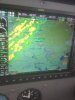
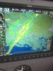
Today, I saw what appears on radar to be a similarly shaped storm. The intensity wasn't as high. It is a little hard to see, but only a few places showed some pink/red extreme precip. Most of it was yellow.
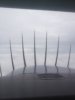
I flew right across the storm system, at places the rain was heavy, the ride was generally pretty good, I was just above freezing so I avoided the ice that was certainly higher, pretty uneventful system crossing.
Number one concern for me was convection (I check even in winter). I had Baton Rouge approach call Polk approach (near Alexandria) and ask about convection (Neg.). I asked about pireps, of course there were none. Airlines coming out of Baton Rouge reported neg. convection. I didn't mess with flight service, because they never seem to know "S" other than the forecast. So on we go.
The winds were ripping 55+ at 8K. This was interesting because I like to match up radar features of a storm with a visual. When I was able to get a visual and match them it was clear the storm was moving quickly. This was a good day to do this because the XM refresh rate vs. the storm progress was disparate.
The other thing I did is get a block altitude BEFORE the worst of it. Why? Because the temp was hovering about 2-3 degrees. I know that inside a storm system the temps can drop instantly, in which case I would have been in ice or possibly freezing rain. I didn't want to have to negotiate with ATC and possibly wait even a minute or two. Since the precip. was so heavy at the first sign of ice my plan was to go down fast. I ended up not needing to, but on occasions where I have had to make a move when minutes count it is nice to not worry about altitude.
Anyway, here are the pics. Approaching the system. Wider view of the system. Approaching the system out the window. Last just before going IMC for 50 miles.
As I said above, this one turned out to be easy, but the process is the same to prepare for the ones that are not. The worst thing about this flight was the 50+ winds right on the nose the entire way, sheesh, some days.
Often in the summer a system will pick up power over the gulf and head northeast across the Texas Louisiana border. These storms often have a lot of convection and power. Commonly a thin powerful squall line type of storm. Even crossing them in a seemingly benign area can be a wild ride. I approach the summer storms with a great deal of caution.
Today, I saw what appears on radar to be a similarly shaped storm. The intensity wasn't as high. It is a little hard to see, but only a few places showed some pink/red extreme precip. Most of it was yellow.
I flew right across the storm system, at places the rain was heavy, the ride was generally pretty good, I was just above freezing so I avoided the ice that was certainly higher, pretty uneventful system crossing.
Number one concern for me was convection (I check even in winter). I had Baton Rouge approach call Polk approach (near Alexandria) and ask about convection (Neg.). I asked about pireps, of course there were none. Airlines coming out of Baton Rouge reported neg. convection. I didn't mess with flight service, because they never seem to know "S" other than the forecast. So on we go.
The winds were ripping 55+ at 8K. This was interesting because I like to match up radar features of a storm with a visual. When I was able to get a visual and match them it was clear the storm was moving quickly. This was a good day to do this because the XM refresh rate vs. the storm progress was disparate.
The other thing I did is get a block altitude BEFORE the worst of it. Why? Because the temp was hovering about 2-3 degrees. I know that inside a storm system the temps can drop instantly, in which case I would have been in ice or possibly freezing rain. I didn't want to have to negotiate with ATC and possibly wait even a minute or two. Since the precip. was so heavy at the first sign of ice my plan was to go down fast. I ended up not needing to, but on occasions where I have had to make a move when minutes count it is nice to not worry about altitude.
Anyway, here are the pics. Approaching the system. Wider view of the system. Approaching the system out the window. Last just before going IMC for 50 miles.
As I said above, this one turned out to be easy, but the process is the same to prepare for the ones that are not. The worst thing about this flight was the 50+ winds right on the nose the entire way, sheesh, some days.

")