jasc15
Pre-takeoff checklist
I haven't seen anything in the A/FD that specifies the range of a VOR, so how can I tell at what distance a reliable signal can be acquired?
I haven't seen anything in the A/FD that specifies the range of a VOR, so how can I tell at what distance a reliable signal can be acquired?
Jim- that calculation is built into the VOR type (high altitude, low attitude, and terminal). Also considered is the proximity of other VORs on the same frequency that may interfere with each other.
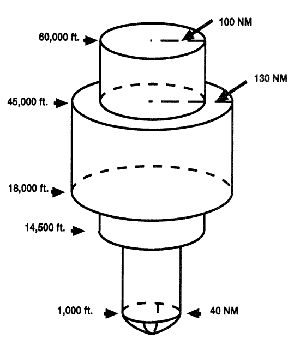
The service radius of HVOR decreases from 130 nautical miles to 100nm above 45,000 feet because of the possibility of picking up multiple VORs. An image depicting this service area for an HVOR is shown below. The various VORs also have differing power that affects the range as well ranging from 50W for a TVOR through 200W for a HVOR.
Fair enough- the people that do go above 14.5 would know this already.I respectfully beg to differ.
First of all, those of us in here rarely fly above 12.5, so the 40 mile ring from 1000 to 14,500 is just not true. Neglect all that stuff above 14.5.
Look at the energy picked up by various radio telescopes. Although very powerful at the source, the distance (hundreds of light years) means not much power is actually detectable here. We understand radio can be picked up over long distances if not attenuated. Picking up something from space isn't the question here.Second of all, the theoretical range of a 1 watt transmitter on one end and a 1 microvolt receiver on the other end is something on the order of 1300 miles. Don't believe it? I've got a confirmation card from the Space Shuttle confirming contact with a 1 watt transmitter on my end and whatever they've got up there as a receiver.
Off airways, I'll just go with the service area the FAA (or whoever defines such things) guarantees- as listed in the AF/D. I'll leave the QSL for when I'm not navigating.Third, that 40 mile cylinder is really a cone that gets much bigger the higher you go. A 100 mile range at 10.5 is what most of us expect out in the west, where VORs are few and far between and interference on the same frequency is a minimum.
Jim
I'm not Roncachamp, so I'll stop here...

OK, all good info even if it was more than i needed. I also tend to go overboard myself with information, so it is all welcome even if only as a curiosity. Now one other question: Are all VORs located on airport grounds classified "terminal", or should I still look these up on a case-by-case basis?
The only thing you can know a priori about whether you can pick up the signal (other than on a published route or intersection, which are all flight-checked OK even if beyond the SSV) is to use the SSV from the AIM less any published additional restrictions in the AIM or NOTAMs. Once in the air, if you get a good ID, good TO/FROM, no red flag, and a stable needle, you are receiving the signal "suitable for navigation," and can use it, but beyond the SSV, that can vary from day to day due to a host of conditions ranging from atmospherics to trucks driving by the VOR station."how can I tell at what distance a reliable signal can be acquired?"
The only thing you can know a priori about whether you can pick up the signal (other than on a published route or intersection, which are all flight-checked OK even if beyond the SSV) is to use the SSV from the AIM less any published additional restrictions in the AIM or NOTAMs. Once in the air, if you get a good ID, good TO/FROM, no red flag, and a stable needle, you are receiving the signal "suitable for navigation," and can use it, but beyond the SSV, that can vary from day to day due to a host of conditions ranging from atmospherics to trucks driving by the VOR station.