scottd
Pre-takeoff checklist
..........
....................
....................
Last edited:
Can you be more specific? Details please.
")
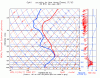
I must have missed that discussion. How is it that you can get freezing rain without the temperatures being above freezing at some point?You've told us before that to get SLD/freezing rain you don't necessarily need to have an inversion that goes above freezing. So in that 700 mbar range down to the surface, I'd expect to see freezing rain/SLD.
I must have missed that discussion. How is it that you can get freezing rain without the temperatures being above freezing at some point?
Interesting. I didn't know that.The key here is that ice nuclei (similar to condensation nuclei) don't become active until the temperature reaches about -12°C. Once the cloud top temperature becomes colder than this, ice crystals begin to form...which usually happens near the top of the cloud. At that point, the cloud begins to quickly build ice crystals at the expense of supercooled liquid water which generally lessens the structural icing threat. When the cloud top temperature is warmer than -12°C, you can be guaranteed that the cloud is dominated by supercooled liquid water.
Now there are variations to this...sometimes higher (colder) clouds can "seed" these lower clouds with ice crystals starting the crystal process in the lower and warmer cloud deck.
We're going to see this process take place here in Charlotte, NC on Monday and Tuesday. It'll start out as snow and then dryer air will move in aloft (mid-layers of the atmosphere) and effectively cut off the supply of ice crystals changing the precip to freezing drizzle.
The sounding I posted is referred to as non-classical SLD and will likely produce freezing drizzle at the surface. I've also discussed some of this in this FREE e-Tip. One you introduce ice crystals into a supercooled environment, you can change the cloud over to a process that builds snow, not drizzle or rain.
I don't understand this part either but I will take for granted that it is true.I'm still not clear on the physics of the formation - phase changes involving solids are well outside of the realm of physics I work in.
What do you mean when you say "become active"?The key here is that ice nuclei (similar to condensation nuclei) don't become active until the temperature reaches about -12°C.
This would be an ideal condition when climbing to avoid icing is the proper response, correct?Once the cloud top temperature becomes colder than this, ice crystals begin to form...which usually happens near the top of the cloud. At that point, the cloud begins to quickly build ice crystals at the expense of supercooled liquid water which generally lessens the structural icing threat. When the cloud top temperature is warmer than -12°C, you can be guaranteed that the cloud is dominated by supercooled liquid water.
Now there are variations to this...sometimes higher (colder) clouds can "seed" these lower clouds with ice crystals starting the crystal process in the lower and warmer cloud deck.
I don't understand this part either but I will take for granted that it is true.
Without writing a book here, two phase transitions can lead to ice crystal formation: the freezing of a liquid drop or the direct deposition (sublimation) of vapor to the solid phase. Both are nucleation processes, and in principle homogeneous and heterogeneous nucleation are possible. ...
.

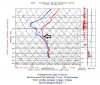
Here is what I came up with for the local area. It's been snowing all day. I guess it's snow and not freezing drizzle because the temps in the clouds are pretty cold, all the way down to -40C.You don't, but there are clues that can tell you about this as well.

But even if the cloud tops were still cold how would the crystals get to the lower, warmer, part of the cloud in order for those droplets to also freeze?No. As the air dries out aloft, it causes the cloud top temperatures to warm...the tops of the clouds become lower. As this happens, the tops go from -25°C (which allows ice crystal production) to -10°C which limits or cuts off the production of ice crystals.
I googled this term but couldn't really come up with anything that looked relevant. Do you mean that the ice crystals at the top of the cloud get heavy enough to fall so that they become nuclei for the droplets in the lower part of the cloud?Turbulent mixing and precipitation scouring are two examples.
As long as one part of a cloud has ice crystals forming it tends to migrate to the other parts even if the cloud is pretty large both vertically and horizontally? I understand about the mixing. In the Denver example the wind isn't particularly strong although there is some windshear at about 12,000' which would put it just about at the ridge level west of here.But once you introduce ice crystals into a cloud, it tends to build more ice crystals at the expense of supercooled liquid water.
Yes, absolutely! I'm still not sure how you determine some of those things from the charts but I'll look at the website.Thanks for the lesson, Scott.
Yes, absolutely! I'm still not sure how you determine some of those things from the charts but I'll look at the website.