Brad W
Pattern Altitude
What is the lag time before they update charts?
I live adjacent to an old WW2 Navy OLF
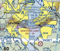
Here it is shown as a closed airfield in this screen capture from skyvector.com

Runways are long gone since well before I moved here about 13 years ago, and for most if that time it has been a thick stand of young pines. You could sort of see where the runways one were from the air and on google maps, with the pines where the runways were younger than the surrounding woods, so useful landmark maybe.
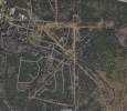
this screen capture from google maps if I had to guess was an image from at least six or seven years ago, maybe a bit more.

It has been a neighborhood, and for about the last 2 years or so it's been gone. At least half or more of it is developed houses, and the other areas are just clear cut and bulldozed dirt pits slowly transforming into neighborhood streets and lots.
I walked back in there to the runway intersection just before they clear cut it a couple years ago, and the pines were large, basically not even close to resembling an airfield....
I was out walking the dog there this morning pondering why it's still on the sectional.
Has it always taken this long to update features such as this?
I live adjacent to an old WW2 Navy OLF
Here it is shown as a closed airfield in this screen capture from skyvector.com

Runways are long gone since well before I moved here about 13 years ago, and for most if that time it has been a thick stand of young pines. You could sort of see where the runways one were from the air and on google maps, with the pines where the runways were younger than the surrounding woods, so useful landmark maybe.
this screen capture from google maps if I had to guess was an image from at least six or seven years ago, maybe a bit more.

It has been a neighborhood, and for about the last 2 years or so it's been gone. At least half or more of it is developed houses, and the other areas are just clear cut and bulldozed dirt pits slowly transforming into neighborhood streets and lots.
I walked back in there to the runway intersection just before they clear cut it a couple years ago, and the pines were large, basically not even close to resembling an airfield....
I was out walking the dog there this morning pondering why it's still on the sectional.
Has it always taken this long to update features such as this?
