Weather Geeks: Surfance Analysis Chart Question

AggieMike88

Touchdown! Greaser!
Joined
Jan 13, 2010
Messages
20,805
Location
Denton, TX
Display Name

Display name:
The original "I don't know it all" of aviation.
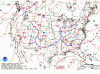
I'm starting to review the weather details for the Gastons trip. And saw something to ask a question about on the Surfance Analysis Chart.

Take a look at western Illinois where the eastern end of the cold front makes a V-shaped pocket with the stationary front.

Am I remembering right that when we see this, that area will be some pretty gnarly weather? Possibly some significant storms?

attachment.php
 

Attachments

  • sfc5.gif
    sfc5.gif
    43.1 KB · Views: 105
Last edited:
That is called an occluded front :

There are two types of occlusion, warm and cold. In a cold occlusion, the air mass overtaking the warm front is cooler than the cool air ahead of the warm front, and plows under both air masses. In a warm occlusion, the air mass overtaking the warm front is not as cool as the cold air ahead of the warm front, and rides over the colder air mass while lifting the warm air.
A wide variety of weather can be found along an occluded front, with thunderstorms possible, but usually their passage is associated with a drying of the air mass. Additionally, cold core funnel clouds are possible if shear is significant along the cold front. Occluded fronts are indicated on a weather map by a purple line with alternating semicircles and triangles pointing in direction of travel. Occluded fronts usually form around mature low pressure areas.
 
OUR REGION WILL BE UNDER THE INFLUENCE OF A NORTHWESTERLY FLOW
REGIME THIS WEEKEND INTO EARLY NEXT WEEK. THIS WILL BRING PERIODIC
CHANCES FOR SHOWERS AND THUNDERSTORMS. A COUPLE OF MINOR DISTURBANCES MAY BRING INTERVALS OF CLOUDS TO
PORTIONS OF THE AREA FRIDAY AND SATURDAY. A FEW LIGHT SHOWERS OR
SPRINKLES CANNOT BE RULED OUT. IT APPEARS MOISTURE AND LIFT WILL
CONFINED TO THE MID LEVELS WHICH WILL LIMIT COVERAGE AND AMOUNTS
OF ANY RAINFALL THAT DEVELOPS.
MEDIUM RANGE MODELS CONTINUE TO SUGGEST THE DEVELOPMENT OF MESO-SCALE CONVECTIVE COMPLEX LATER SATURDAY OR SATURDAY NIGHT ACROSS THE PLAINS THEN TRACK IT TOWARD THE OZARKS. ADDITIONAL CHANCES OF CONVECTION MAY DEVELOP NEXT WEEK AS
DISTURBANCES TRACK AROUND THE PERIPHERY OF THE UPPER RIDGE.
WHILE CHANCES OF RAINFALL EXIST SATURDAY NIGHT INTO NEXT WEEK THE
TIMING AND PLACEMENT OF THIS ACTIVITY REMAINS UNCERTAIN.
 
I am watching (with no small degree of dismay) the weather between my place and Gaston's. Sigh... maybe Saturday will be better. This is why I'm starting IFR study.
 
The area where those two meet and the purple area north of it, avoid flying through that.
 
Thanks Scott...

I was working the roadmap you demonstrated a few weeks ago for the Gaston's trip when I spotted the occluded front.
 
Back
Top